
Tag Archives: dome

Coal Chute Point and The Pit

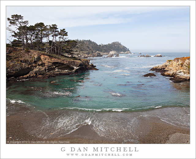
Coal Chute Point and The Pit - Coal Chute Point, the Pit, and the rugged shoreline of Point Lobos State Reserve, California.

Coal Chute Point and The Pit. Point Lobos State Reserve, California. March 29, 2012. © Copyright 2012 G Dan Mitchell – all rights reserved.

Coal Chute Point, the Pit, and the rugged shoreline of Point Lobos State Reserve, California.

(Shortly after posting this, another photographer wrote to suggest that I might consider renaming the image to “Point and Chute.” ;-)

For all the years – decades, actually, and more than a few – that I’ve been visiting Point Lobos, there are still places that I have not gotten around to visiting within the boundaries of the park. Among them are some headlands not far from Whalers Cove that I’ve looked at for a long time… and then always headed off to some other part of the reserve without visiting them. Earlier this week I visited Point Lobos with no particular goal in mind aside from making some photographs, and I somehow finally ended up in this picturesque area that offers some quite different views from those found in the areas that more directly face out into the Pacific. (While it is, indeed, picturesque… the place names are not. Coal Chute Point? The Pit?)

The light in this photograph is somewhat subdued, at least in comparison to some of the photographs you might see of such a place, typically shot in the evening when the sky is at its most colorful. (Yes, I’ve certainly made my share of those photographs at Point Lobos, too!) But this light had a different sort of appeal, and it continuously changed during my half day there. When I arrived some fog was just clearing near the coast. It was a strange pattern – fog way inlands that looked more like the typical winter valley tule fog than the summer coastal fog. In fact, as is frequently the case in winter, it was clear at the coast. But somewhat surprisingly there was a regular old fog bank lurking a ways off the shoreline – and later in the day it moved in on the coast. Along with this there were high, thin clouds from a weather front that was passing well to the north. These conditions can still provide directional light but light which is softer and can fill in the shadows a bit – making it possible to shoot in places and at times of the day when the light might otherwise be too harsh. For this photograph I decided to “go wide,” and shoot with a 24mm focal length of a full frame DSLR to accentuate the distance between the foreground beach and the distant horizon and to include the full width of the curving wave as it broke on the beach.

G Dan Mitchell is a California photographer whose subjects include the Pacific coast, redwood forests, central California oak/grasslands, the Sierra Nevada, California deserts, urban landscapes, night photography, and more.
Blog | About | Flickr | Twitter | FacebookGoogle+ | 500px.com | LinkedIn | Email

Text, photographs, and other media are © Copyright G Dan Mitchell (or others when indicated) and are not in the public domain and may not be used on websites, blogs, or in other media without advance permission from G Dan Mitchell.
Tenaya Lake, January 2012

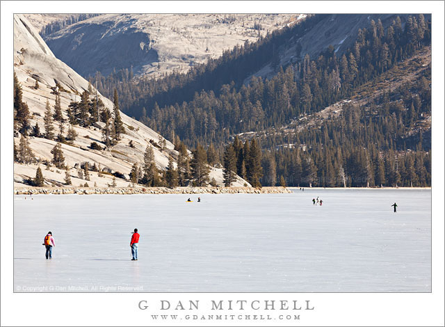
Tenaya Lake, January 2012 - Skaters and walkers on frozen Tenaya Lake, accessible via the still-open Tioga Pass Road on January 16, 2012.
Skaters and walkers on frozen Tenaya Lake, accessible via the still-open Tioga Pass Road on January 16, 2012.

Tenaya Lake, January 2012. Yosemite National Park, California. January 16, 2012. © Copyright 2012 G Dan Mitchell – all rights reserved.

Skaters and walkers on frozen Tenaya Lake, accessible via the still-open Tioga Pass Road on January 16, 2012.

I have been meaning to post this photograph since I made it last month, on January 16, 2012. The serious California drought (or so it seems) of 2012 created very unusual conditions in the Sierra this winter. The Tioga Pass Road (highway 120) through Yosemite National Park usually closes by some time in November, and has been known to close as early as October. The early season this year made it appear that we might have a normal or even heavier than normal winter – early storms near the beginning of October brought a lot of snow to the range and temporarily closed the road more than once. But by December it became clear that this was not going to be a normal year at all, and by the end of the month there was almost no snow anywhere in the range.

A week before this visit I had crossed and re-crossed the pass on a trip to Death Valley. While I appreciated the convenience and shorter drive, I found the odd conditions unnerving. Aside from a few patches here and there, I saw no snow at all, though the seasonal cold had frozen the high country lakes. A week later it looked like a storm or two might finally arrive, so we decided to make the trip up to the Tuolumne area to see the high country in a state that we probably (hopefully!) won’t see again. During the week before this visit, local news stations around California had made this story well known, and they almost all mentioned that people were visiting Tenaya Lake. And, indeed, there were tons of people at the lake when we arrived. There were about as many cars as you might see on an August afternoon. People were clustered along the frozen edge of the lake, were walking along its borders, even setting up tables for picnics on the ice. A few people thought to bring ice skates and they were skating great distances. (Fortunately for us, most people went no farther than Tenaya, and the crowds decreased rapidly after that point.)

G Dan Mitchell is a California photographer whose subjects include the Pacific coast, redwood forests, central California oak/grasslands, the Sierra Nevada, California deserts, urban landscapes, night photography, and more.
Blog | About | Flickr | Twitter | FacebookGoogle+ | 500px.com | LinkedIn | Email

Text, photographs, and other media are © Copyright G Dan Mitchell (or others when indicated) and are not in the public domain and may not be used on websites, blogs, or in other media without advance permission from G Dan Mitchell.
Merry Christmas 2011!

Yosemite Valley, New Snow, Morning - Classic winter view of snow-covered Yosemite Valley scene photographed from Wawona Tunnel View after a late-winter storm.

Yosemite Valley, New Snow, Morning. Yosemite National Park, California. March 4, 2006. © Copyright 2006. G Dan Mitchell – all rights reserved.

Merry Christmas 2011!

It has been a bit of a tradition to post a photograph of Yosemite Valley in snow on Christmas Day – it seems like the Sierra way to send seasons greetings! I hope that you and yours are having a wonderful holiday!

(The photograph was made on the morning after a late-winter snow storm in The Valley back in 2006.)

G Dan Mitchell is a California photographer whose subjects include the Pacific coast, redwood forests, central California oak/grasslands, the Sierra Nevada, California deserts, urban landscapes, night photography, and more.
Blog | About | Flickr | Twitter | FacebookGoogle+ | 500px.com | LinkedIn | Email

Text, photographs, and other media are © Copyright G Dan Mitchell (or others when indicated) and are not in the public domain and may not be used on websites, blogs, or in other media without advance permission from G Dan Mitchell.

Granite Ridge and Trees

Granite Ridge and Trees

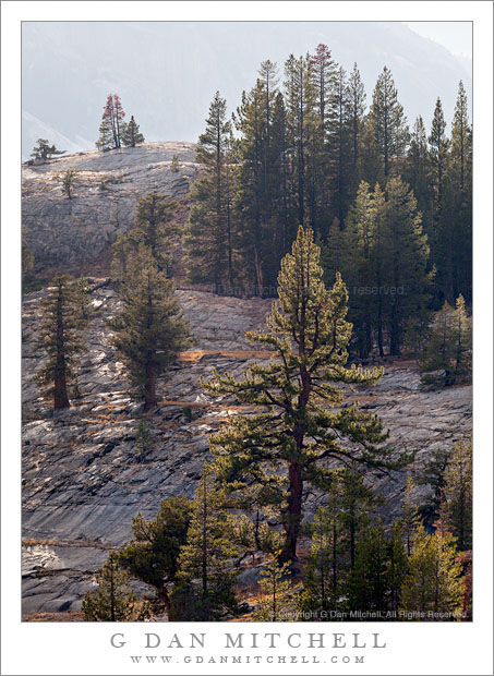
Granite Ridge and Trees. Yosemite National Park, California. September 6, 2011. © Copyright 2011 G Dan Mitchell – all rights reserved.

A backlit granite ridge above the Tuolumne River is topped by trees.

I think that this is probably going to be the final riff on the subject of this particular ridge, the subject of several photographs I have posted in recent weeks. As I probably wrote at least once before… I climbed up from our camp onto the top of a small dome-like granite whaleback that gave me an open view in almost all directions and a high point from which to look over a good section of the Tuolumne River as it passes through a section of the Yosemite back-country. I arrived at this spot in the very late afternoon and then stayed there for perhaps two hours as the light gradually shifted from that of afternoon to sunset and then twilight.

This photograph was made before the golden hour, though I think that a bit of added warmth is already beginning to appear in the color of the light. The sun was coming from above the distant ridge seen faintly through the haze above the valley of the Tuolumne, and it was periodically blocked by some high clouds. While the clouds can “blah-ify” the light pretty effectively, when they are not completely covering the sky they can cast interesting and temporary light across the landscape as they move past. For a moment the light came brightly through the clouds and back-lit these beautiful trees that were growing on the granite surface of this dome.

G Dan Mitchell is a California photographer whose subjects include the Pacific coast, redwood forests, central California oak/grasslands, the Sierra Nevada, California deserts, urban landscapes, night photography, and more.
Blog | About | Flickr | Twitter | FacebookGoogle+ | 500px.com | LinkedIn | Email

Text, photographs, and other media are © Copyright G Dan Mitchell (or others when indicated) and are not in the public domain and may not be used on websites, blogs, or in other media without advance permission from G Dan Mitchell.