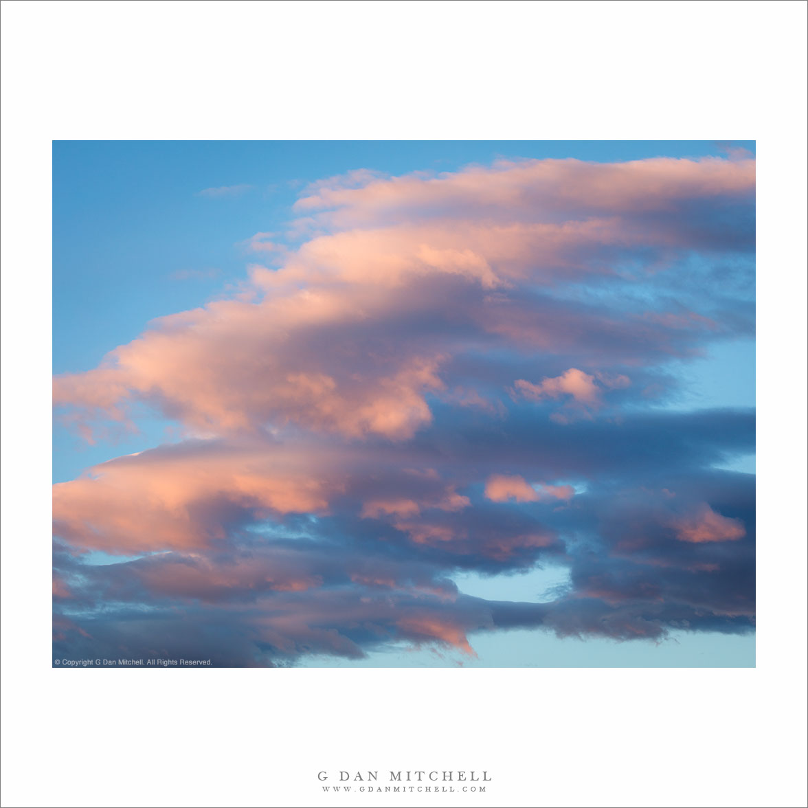
Tag Archives: dramatic

Evening Storms

Evening Storms
Evening rain clouds and dust storm above the Panamint Mountains, Death Valley National Park

Evening Storms. Death Valley National Park, California. © Copyright 2016 G Dan Mitchell – all rights reserved.

Evening rain clouds and dust storm above the Panamint Mountains, Death Valley National Park

This was a wild evening in Death Valley. While the clouds were generally moving toward clearing, we first saw extreme weather of several types. Down close to the ground there were big, billowing clouds of sand and dust being lofted above the Valley floor. High above that wildness huge weather front clouds built above desert mountains.

In the evening I decided to go our for one more photographic chase, even though the weather hardly seemed conducive to photography. In this case I resorted to an approach that I’ve used before in storms like this one, namely to put on the long focal length lens and shoot into the maelstrom from a distance. It this case, two storms were present at once: While high winds whipped up the sand and dust storm closer to the ground, overhead the monumental clouds of a rain storm towered over the desert mountains.


G Dan Mitchell is a California photographer and visual opportunist. His book, “California’s Fall Color: A Photographer’s Guide to Autumn in the Sierra” is available from Heyday Books and Amazon.
Blog | About | Flickr | Twitter | FacebookGoogle+ | LinkedIn | Email


All media © Copyright G Dan Mitchell and others as indicated. Any use requires advance permission from G Dan Mitchell.

Red Rock, Capitol Reef

Red Rock, Capitol Reef - Red rock sandstone formations, Capitol Reef National Park, Utah.
Red rock sandstone formations, Capitol Reef National Park, Utah.

Red Rock, Capitol Reef. Capitol Reef National Park, Utah. April 5, 2012. © Copyright 2012 G Dan Mitchell – all rights reserved.

Red rock sandstone formations, Capitol Reef National Park, Utah.

I’m afraid that our time in Capitol Reef National Park during our early April visit to Utah was extremely limited – essentially we just passed through on highway 12 on the day we travelled from Zion (where we had spent several days) to Moab. I wish I could have had some real time to explore this area, but at least I got a glimpse of it – enough that I know to put in on my list of places to revisit when I have more time on a future trip.

As we passed through Capitol Reef, aside from viewing things from the car, we made two stops. One was in the Fruita district area to see some petroglyphs and the other was this viewpoint along the highway, from which there was an impressive panorama of the beautiful red rock country. Although this was perhaps not the ideal time of day for photography, the weather gods cooperated enough to give me a bit of high, thin overcast to soften the light and to place these beautiful layered clouds above and beyond the sandstone ridge.

G Dan Mitchell is a California photographer whose subjects include the Pacific coast, redwood forests, central California oak/grasslands, the Sierra Nevada, California deserts, urban landscapes, night photography, and more.
Blog | About | Flickr | Twitter | FacebookGoogle+ | 500px.com | LinkedIn | Email

Text, photographs, and other media are © Copyright G Dan Mitchell (or others when indicated) and are not in the public domain and may not be used on websites, blogs, or in other media without advance permission from G Dan Mitchell.

Mono Lake, Thunderstorm

Mono Lake, Thunderstorm

Mono Lake, Thunderstorm. Mono Lake, California. July 23, 2007.© Copyright 2007 G Dan Mitchell – all rights reserved.

Eastern Sierra Nevada thunderstorms build over Mono Lake, Mono Craters, and Lee Vining, California.

Mono Lake can be an unforgiving place in which to try to make photographs during the day, but sometimes one gets lucky! It is a wonderful place, but if you only know it from photographs – which, of course, tend to be made at the most appealing times – you might not know that it is often hot and hazy and dry during the day. These are among the reasons that it is a place often photographed at dawn or at sunset on days when the clouds are interesting. (The latter poses its own set of problems, since the Sierra Nevada range begins to block the light well before actual sunset.)

But I did get lucky on this late July afternoon. It was thunderstorm weather, so there were some very impressive clouds floating around. However, the clouds did not completely fill the sky, so patches of light were moving across the landscape – in this photograph one illuminates the green area at far right along the shore and, more importantly, the Mono Craters beyond the far shore of the lake. And the vegetation around the lake was still green, or at least green enough to look alive in this light.

G Dan Mitchell Photography
About | Flickr | Twitter | FacebookGoogle+ | 500px.com | LinkedIn | Email

Text, photographs, and other media are © Copyright G Dan Mitchell (or others when indicated) and are not in the public domain and may not be used on websites, blogs, or in other media without advance permission from G Dan Mitchell.

(Basic EXIF data may be available by “mousing over” large images in posts when this page is viewed on the web. Leave a comment if you want to know more.)

Owens Valley Sky

Owens Valley Sky
Owens Valley Sky

Owens Valley Sky. Owens Valley, California. August 6, 2005. © Copyright 2011 G Dan Mitchell – all rights reserved.

Dramatic thunderstorms begin to build above Owens Valley, flanked by the White Mountains and the eastern Sierra Nevada range.

If there is any good news about starting to run out of space on my hard drive, it might be that it encourages me to begin the process of reviewing my tens of thousands of archived raw image files, and that leads me to look through files that I haven’t revisited in a long time – and during this process I find photographs that I had forgotten about. Not only is it worthwhile to rediscover these photographs that ended up buried in the archive, but it is also a chance to recall some of the trips on which the photographs were made.

This photograph is yet another (of many!) that wouldn’t have happened at all if it were not for a whole unpredictable series of events and circumstances. I’ll make the story as short as I can, but it is still a bit involved. Almost every summer I share a long pack trip with a group of my friends. In 2005 we had come up with a 14-day trip along a good portion of the John Muir Trail between roughly the Ediza Lake area and Bishop Pass, which included one of the very few sections of the JMT that I had not hiked. We started at Agnew Meadow, headed up past Shadow Lake, turned south on the JMT, stopped at Reds Meadow, continued on to the Duck and Purple Lakes area… where I started to feel like I might be coming down with some sort of bug. Discretion being the better part of valor and all that, I decided that the prudent thing was to bail out of the trip and exit to Mammoth Lakes since the idea of getting sick on the fourth day of a 14-day hike with a large group was not appealing.

So I hiked out. Ironically, once I crossed the pass to head down to the Mammoth area, I recovered – but it was now too late to rejoin my group since they would be two days ahead of me on the trail at this point. Since I was back at my car now and feeling just fine I figured that I might as well do something else before heading home, so I decided to drive up into the White Mountains and visit the Bristlecone Pine forest. On the way back down from the Whites I just happened to pull out at this spot where the high desert terrain was extra green around a creek, on an afternoon when monsoon conditions were leading to a buildup of afternoon clouds above the Sierra, the Whites, and Owens Valley between the two ranges.

G Dan Mitchell Photography
About | Flickr | Twitter | FacebookGoogle+ | 500px.com | LinkedIn | Email

Text, photographs, and other media are © Copyright G Dan Mitchell (or others when indicated) and are not in the public domain and may not be used on websites, blogs, or in other media without advance permission from G Dan Mitchell.

(Basic EXIF data may be available by “mousing over” large images in posts. Leave a comment if you want to know more.)