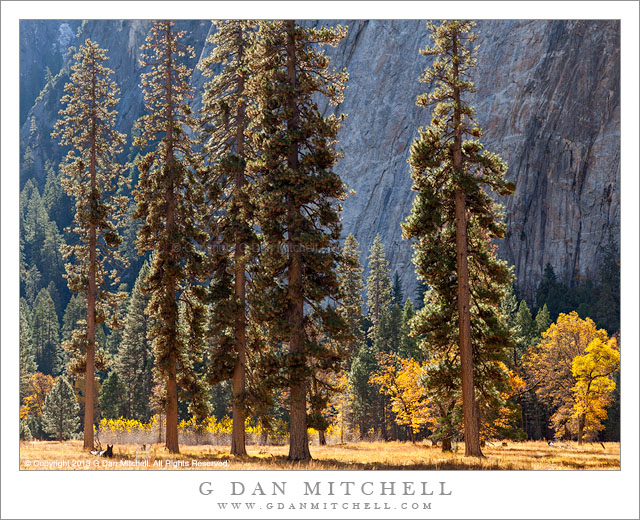
Tall trees grow in a row in a meadow backed by cottonwood and black oak trees with autumn foliage
I guess I just can’t help myself when it comes to photographing in this Yosemite Valley meadow area – or in similar areas, for that matter. As I’ve written before, during the time of the year when the days are shorter and the sun is lower, the light in some of these places is constantly changing – pre-sunrise and post-sunset soft “blue hour” light, early and late direct sun over the upper edges of cliffs, shadow right after dawn and before sunset and when cliffs interrupt the light during midday hours. Other changes take place on a longer cycle – the stark quality of winter, snow covering everything when winter storms arrive, morning fog, trees newly green in spring or yellow and gold in fall. And there are many more things to see than just the “landscape size” things – wildflowers, fallen leaves, frost, and more.
So, yes, I visited and revisited the meadows during this fall’s end-of-October visit to The Valley. While I often focus on the black oaks that grow in these meadows, here I decided to focus on evergreen trees. This group stands almost evenly spaced in a row. I struggled with how to deal with their height when shooting from a relatively close distance, and then realized that by not including the whole tree I could emphasize the vertical lines of their trunks and perhaps suggest the even higher parts of the trees that are not visible here.
G Dan Mitchell is a California photographer and visual opportunist whose subjects include the Pacific coast, redwood forests, central California oak/grasslands, the Sierra Nevada, California deserts, urban landscapes, night photography, and more. Blog | About | Flickr | Twitter | Facebook | Google+ | 500px.com | LinkedIn | Email
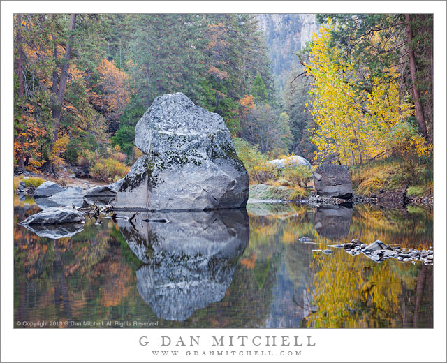
A large boulder is exposed by low autumn water levels in the Merced River
On the final two days of October this year, I did what I often do at this time of year – make a visit to Yosemite Valley to photograph fall colors. As is the case with fall colors in many places in the west, the transition seemed to come a little earlier than usual, and this might have been just a bit too late for some colors (big leaf maples) and perhaps a bit early for others (cottonwoods) but overall a fine time to be in the Valley. (This season was a bit strange in many places in the west, including many where I often photograph. For example, the arrival of the fall aspen color was early, though it did hang on for a good long time.)
This scene along the Merced River says “autumn” in ways that are both obvious to anyone and perhaps less so unless you know the Valley a bit. In the obvious category are the colors of trees along the banks of the river, mostly big leaf maple and oak in this photograph. Other aspects include the very low water level and the quiet flow of the river. In the spring this section of the Merced can be a wild flood of snow melt runoff that rises toward the top of the large boulder – but so late in the season, especially in a very dry year like this one – the river has a much gentler and quieter personality. The light is also different – with the low sun angle there is no direct light at the bottom of the canyon here and none on the section of valley wall visible in the distance. The atmosphere has some of the same feeling that the river has – a bit hazy, little air movement, and at times a softer quality of light.
G Dan Mitchell is a California photographer and visual opportunist whose subjects include the Pacific coast, redwood forests, central California oak/grasslands, the Sierra Nevada, California deserts, urban landscapes, night photography, and more. Blog | About | Flickr | Twitter | Facebook | Google+ | 500px.com | LinkedIn | Email
Overlooking old Heidelberg, Germany and the Neckar River from the Philosophen Weg
This is another “postcard” photo of Heidelberg, from our July 2013 visit. (Which was part of a larger trip that included London, Bavaria, and a bit of Austria.) The scene overlooks the Neckar River as it flows past the old town section of Heidelberg, surrounded by forest and sitting below the historic castle.
Although it is a postcard view, those people are members of our extended family, many of whom joined us on this memorable trip. (You know who you are! :-) The little overlook is along a path known as the Philosophen Weg, or “philosophers way,” that follows along the side of a ridge that parallels the river above the bank opposite the old town. We stayed within a few minutes walk of the lower end of this route and we used parts of it to walk to the old town and back. On this morning, all of us climbed the hill and then followed the path beyond the area seen here, descended to a little place for brunch, and then headed back into the town.
G Dan Mitchell is a California photographer and visual opportunist whose subjects include the Pacific coast, redwood forests, central California oak/grasslands, the Sierra Nevada, California deserts, urban landscapes, night photography, and more. Blog | About | Flickr | Twitter | Facebook | Google+ | 500px.com | LinkedIn | Email
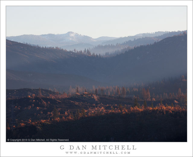
Hazy morning light filters across the burned hillsides in the area of the Rim Fire, California
In photographic terms this is perhaps not the most spectacular photograph, and the location is not quite a scenic icon – though it is a place that many stop and take a look on their way to Yosemite, the “Rim of the World” overlook along highway 120 between Groveland and the northern park entrance. However, this view is loaded with implications and connected to many stories.
Late this past summer, the state of California was tremendously dry after a second drought season. It wasn’t a question of whether there would be big wildfires, but more of where, when, and how many. Perhaps the biggest one of all started very near the Rim of the World overlook, and in the hot and dry conditions it quickly – some might say explosively – spread to the north, east, and south. While many think of it as “the Yosemite fire” – and it did burn a lot of terrain inside the park – it really was more of a “Yosemite area” fire. Because of the conditions – the long-term conditions of drought and the immediate conditions of heat and wind – the fire apparently did very serious damage to the forests in the are.
Shortly after the fire was contained, I thought that I might drive through the park on Tioga Pass Road to get to and from the eastern Sierra in early October. In fact, the roads had opened up again by that time, but snow closed Tioga Pass on my trip to the west and we ended up coming back over Sonora Pass. So the post-fire conditions of this area, which is very familiar to me after years of visits, were still an unknown when I drove to The Valley on October 30 for a few days of autumn photography. Passing into the first fringes of the burned areas along highway 120 things didn’t look all that different than they do after any wildfire – some areas badly burned, some singed, and others that mostly escaped the fire. I decided to stop at the Rim of the World overlook, which was pretty much the only place where stopping was allowed, and get out and take a look. I was floored by the scale of the fire. It had come from behind my position, burned down and across the deep canyon of the Tuolumne River, up the canyon walls on the far side, and then across a vast series of receding ridges. Some smoke and haze still seemed to be coming from the area, and early morning light glanced across the ridges, with their dead trees. In the far distance there is a low peak with a bit of early season snow.
I have seen quite a few fires in the park over the past few decades. One not far from here destroyed a large area of forest a few decades ago – and on this trip, ironically, I was noting that new evergreen trees are finally taking hold there. Later several very bad fires blew up from near Foresta, doing terrible damage to the section of Crane Flat Road descending towards The Valley. There have been others. In most of these cases – though I wondered in the case of the most recent Foresta fire, too – it seemed that I could watch the forest recover and return to something resembling what I remember. However, given the intensity and scale of this fire, I wonder if I’ll have that opportunity where the Rim Fire burned?
To end on a cheerier note, a couple of other observations. Even near badly burned areas, I did see sections where this fire only burned some of the vegetation and a few that seemed to have been completely spared. And when I got to a spot inside the park along highway 120 where I often stop to photography dogwood trees in the spring and fall, a spot that seemed like it might have been within the burn zone on the maps, I found my little spot completely intact, with the dogwoods turning to fall colors.
G Dan Mitchell is a California photographer and visual opportunist whose subjects include the Pacific coast, redwood forests, central California oak/grasslands, the Sierra Nevada, California deserts, urban landscapes, night photography, and more. Blog | About | Flickr | Twitter | Facebook | Google+ | 500px.com | LinkedIn | Email

 G Dan Mitchell is a California photographer and visual opportunist whose subjects include the Pacific coast, redwood forests, central California oak/grasslands, the Sierra Nevada, California deserts, urban landscapes, night photography, and more.