Tag Archives: license

Point Reyes and Drakes Bay

Point Reyes and Drakes Bay

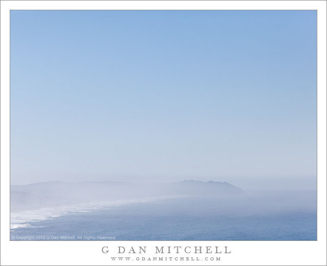
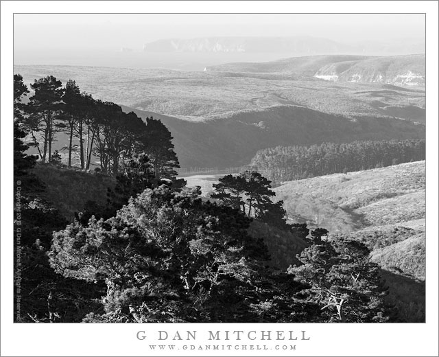
Point Reyes and Drakes Bay. Point Reyes National Seashore, California. February, 9, 2013. © Copyright 2013 G Dan Mitchell – all rights reserved.

Drakes Bay and the Point Reyes Peninsula, viewed from near Mount Vision on Inverness Ridge

After photographing very early in the morning along the shores of Tomales Bay near the town of Inverness, I continued along the road to Point Reyes and soon entered the national seashore. There was a possibility that I might try to meet up with a group of people who planned to photograph the herds of tule elk a bit later in the morning, but at this point I had some time to kill before that might occur. I wasn’t quite sure where I was going to shoot, so I was sort of “following my nose” and the light, atmosphere, and other conditions and waiting to see where I might end up. I had a general idea that it might be interesting to go all the way out to the point itself, where the morning light might illuminate some of the cliffs along Drakes Bay that don’t get that sort of light later in the day.

However, long before I got close to that area I passed a turn-off that I had often noticed and wondered about, a road labelled Mount Vision. With one option looking just about as good as any other option, I decided to head up that road to see what I could see. The road climbs quickly, more or less switchbacking up a steep include and up a few valleys before more or less leveling off high up on Inverness Ridge, actually ascending to the top of the ridge in a few spots and providing panoramic views both towards the ocean and back towards Tomales Bay. Although it wasn’t exactly foggy – at least not in the form that is common here much of the year – the atmosphere was obscured and out at the far end of the peninsula the curving end of Point Reyes was a bit hard to see, and there was a distinct blue quality to the haze that didn’t seem like it was going to work especially well for a color photograph. So I started thinking that this scene might work better in black and white. Soon I saw this steep foreground ridge with its tall trees and dark shaded elements and it seemed like its angle and darker tones might set off the lighter and less contrasty elements of the landscape in the distance, from the tree-filled valley in the middle of the frame to the barely visible peninsula near the horizon.

G Dan Mitchell is a California photographer and visual opportunist whose subjects include the Pacific coast, redwood forests, central California oak/grasslands, the Sierra Nevada, California deserts, urban landscapes, night photography, and more.
Blog | About | Flickr | Twitter | FacebookGoogle+ | 500px.com | LinkedIn | Email

Text, photographs, and other media are © Copyright G Dan Mitchell (or others when indicated) and are not in the public domain and may not be used on websites, blogs, or in other media without advance permission from G Dan Mitchell.

Winter Sky, Point Reyes

Winter Sky, Point Reyes

Winter Sky, Point Reyes. Point Reyes National Seashore, California. February 9, 2013. © Copyright 2013 G Dan Mitchell – all rights reserved.

Mist and spray from high surf along Point Reyes Beach beneath winter sky

I made this simply, even minimalist, photograph on the same day that I made the Tomales Bay photographs that I recently posted. After shooting at dawn along Tomales Bay I continued on into the Seashore. Since I didn’t have any particular goal in mind – sometimes it is great to shoot that way! – I first headed up a side road that I had not investigate before, and followed it to its end high on a ridgeline. From there I descended and headed out to the area of the park that is essentially a refuge for a large population of tule elk. There were tons of them and, oddly, the large number of them made photographing them less interesting than I expected.

Many of the elk were grazing along a high bluff overlook the ocean, and as I photographed the animals I kept looking out along the long beach toward the Point, barely visible through the morning mist and sea spray along the edge of the water. I intentionally excluded anything that was not blue from the photograph – even the curving strand of beach at lower left is blue from the haze. A clear day like this is somewhat unusual at Point Reyes, a place that is often fogged in, and the brilliant light filling the immense sky was a sight that I don’t recall seeing here before.

G Dan Mitchell is a California photographer and visual opportunist whose subjects include the Pacific coast, redwood forests, central California oak/grasslands, the Sierra Nevada, California deserts, urban landscapes, night photography, and more.
Blog | About | Flickr | Twitter | FacebookGoogle+ | 500px.com | LinkedIn | Email

Text, photographs, and other media are © Copyright G Dan Mitchell (or others when indicated) and are not in the public domain and may not be used on websites, blogs, or in other media without advance permission from G Dan Mitchell.

Abandoned Buildings, Leadfield

Abandoned Buildings, Leadfield

Abandoned Buildings, Leadfield. Death Valley National Park, California. April 6, 2013. © Copyright 2013 G Dan Mitchell – all rights reserved.

Abandoned buildings at the site of the Leadfield mines, Death Valley National Park

In a way there is really nothing that special about Leadfield. It is one of many, many abandoned outposts and mining sites found all over California and, for that matter, all over the West. These sites remain, though precariously in some cases, as a reminder of a number of things: history that is not all that distant, the people who must have been willing to come to such places and attempt to scratch out a living by mining, the human capacities for misleading others and for falling victim to those who would mislead, and the temporal nature of things that might seem permanent at the time.

I’m no historian, but I can share a few facts about this particular spot. In the 1920s the town – with some semi-permanent buildings and reportedly many tents – came into existence and died again in the span of less than a single year. Although the reports of ore in the area and situation that might allow it to be successfully mined were wild exaggerations or downright lies, a road was built into this rugged area, work was started on a mill, and today there is still plenty of evidence of mines all around the area. I made this photograph from the tailings pile at the entrance to what I think may be the main mine shaft, looking out over the site in what I imagine might be the direction that a person working that mine might have looked. I wonder it these people took as much notice as I did of the tiny and inconsequential appearance of the human landscape against the vast and rugged natural landscape beyond?

G Dan Mitchell is a California photographer and visual opportunist whose subjects include the Pacific coast, redwood forests, central California oak/grasslands, the Sierra Nevada, California deserts, urban landscapes, night photography, and more.
Blog | About | Flickr | Twitter | FacebookGoogle+ | 500px.com | LinkedIn | Email

Text, photographs, and other media are © Copyright G Dan Mitchell (or others when indicated) and are not in the public domain and may not be used on websites, blogs, or in other media without advance permission from G Dan Mitchell.

Layered Sandstone and Red Leaves

Layered Sandstone and Red Leaves

Layered Sandstone and Red Leaves. Zion National Park, Utah. October 22, 2012. © Copyright 2013 G Dan Mitchell – all rights reserved.

The red autumn leaves of a small tree contrast with the angles and layers of a curving sandstone slot canyon, Zion National Park

One of the most intriguing things about slot canyons – among many intriguing things – is the surprising variety of things to be seen as you progress through them. While the basic idea might seem somewhat consistent – e.g. narrow canyon with tall walls and water in the bottom – the details of the canyons seem amazing diverse and they change from moment to moment and bend to bend. This first really made sense to me in a canyon in the Escalante area where we entered by walking down a very wide and flat wash. Gradually a low sandstone “curb” began to appear along the sides of the wash and almost before I knew it this had grown to become a wall. Shortly the bottom of the canyon narrowed so much that we had to rise out of it and walk along side until we got to a point where we could again drop down into it, and it was now deep enough to cut off much of the direct light from overhead.

The slot in this photograph is in Zion National Park, and to be honest I not entirely certain where it was outside of a sort of general area. As we walked through it – and it was not a long canyon – it twisted along the base of a cliff wall and at this spot there was almost no visible vegetation except for the red leaves of one small autumn tree poking out from behind the thickly striated and twisted rock of the canyon side walls.

G Dan Mitchell is a California photographer and visual opportunist whose subjects include the Pacific coast, redwood forests, central California oak/grasslands, the Sierra Nevada, California deserts, urban landscapes, night photography, and more.
Blog | About | Flickr | Twitter | FacebookGoogle+ | 500px.com | LinkedIn | Email

Text, photographs, and other media are © Copyright G Dan Mitchell (or others when indicated) and are not in the public domain and may not be used on websites, blogs, or in other media without advance permission from G Dan Mitchell.