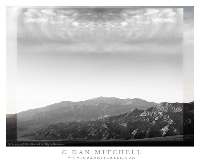
An imaginary landscape derived from subjects photographed in Death Valley National Park.
“Imaginary Landscapes” are images most often derived from photographs of natural scenes and objects, but modified in ways that are not intended to be realistic.
While working on this photograph, I was experimenting with some techniques for post processing images, particularly to control the visibility of features at the very light and very dark ends of the luminosity scale. One thing led to the next, and soon I had darkened the sky, enhanced the dynamic range in the clouds, and tried a monochrome interpretation of the scene. Then I got the idea to play around a bit with the sky and clouds and before long things had progressed to a point that was well beyond believable.
G Dan Mitchell is a California photographer whose subjects include the Pacific coast, redwood forests, central California oak/grasslands, the Sierra Nevada, California deserts, urban landscapes, night photography, and more. Blog | About | Flickr | Twitter | Facebook | Google+ | 500px.com | LinkedIn | Email
First morning light on the rugged landscape of the base of Tucki Mountain and the Panamint Range, Death Valley National Park, California
This photograph was made from a location a ways up from the bottom of Death Valley, from which I could look directly across at the lower slopes of gigantic Tucki Mountain as the first morning light worked its way down toward the lower ridges and the huge alluvial fan at the base of the mountain. At the moment I made the exposure the light was just beginning to fill this slanting area below the rugged mountains, and the light was softened by morning haze.
Tucki Mountain is a huge peak that almost seems to me to be large enough to count as its own minor mountain range. It rises above Stovepipe Wells, and extends a great distance east, south, and west of there. It is laced with deep canyons and its lower slopes are heavily eroded to reveal tilting and twisting strata. Another large valley lies on beyond the foreground spur ridge in this photograph, and beyond that the Panamint Range rises to its crest at 11,000+’ Telescope Peak.
G Dan Mitchell is a California photographer whose subjects include the Pacific coast, redwood forests, central California oak/grasslands, the Sierra Nevada, California deserts, urban landscapes, night photography, and more. Blog | About | Flickr | Twitter | Facebook | Google+ | 500px.com | LinkedIn | Email
UPDATE: As of 2020 I am no longer posting annual updates concerning this subject — and I am editing older posts on the subject in light of the need to be more responsible about not encouraging the onslaught. I also no longer recommend going to the Valley to see it. Unfortunately, too much exposure (yes, I played a part in it, unfortunately) has led to absurd crowds, traffic jams, littering, destruction of areas in the Valley where too many people go to see it… and the park has increasingly — and appropriately — cracked down. Parking options have been eliminated, at least one viewing location has been closed. Good news! The rest of Yosemite Valley is still there and often exceptionally beautiful at this time of year.
The silver strand of Horsetail Fall and water reflecting on surrounding cliffs in late afternoon light, Yosemite Valley.
This being February, it seems that Horsetail Fall has again (and more every year) become a hot topic. Horsetail Fall, sometimes referred to as the “Natural Firefall” has been popularized to an absurd and, frankly, dangerous level on social media and in the press. To be honest, I now recommend that you not go.
The conjunction of elements required to produce the most spectacular Horsetail Fall “event” is complex. First, it depends on the geological coincidences of the placement of the fall in a spot hight on the face of El Capitan that receives a narrow beam of sunset light during two brief periods each year. Second, the fall must be running – in roughly the middle of winter. The area supplying water to the fall is high enough to be snow-covered in a typical winter, but low enough that snow can melt and start the fall flowing even in the cold season – but this is not a sure thing. Essentially, there must be snow and then some warmth to melt it, or else some significant warm rain. Third, a series of meteorological events must play out just right. Obviously, the upper face of El Capitan must be clear of clouds. (Yosemite Valley fog and clouds ringing the cliffs are rather common in the winter season.) The sky west of the Valley must also be clear all the way to the horizon since the best color occurs just before the sun hits the horizon.
Most often the requirements do not align. Many of us can tell stories of light getting better and better, leading toward a brilliant finale… and then the “lights going out” just at the peak of color as the sun dropped behind clouds far to the west.
Hundreds and hundreds Thousands of photographers now show up to try to photograph the thing. I’ve done it in the past, though I’m no longer interested these days – partly because of the absurd crowds and partly because I’m often busy photographing other interesting things!
My best memory of photographing Horsetail was years ago when the park service was doing major road work on Northside Drive, the road along that side of the Valley. The road was completely closed as were the cross-valley roads that travel between Southside and Northside Drives. It had snowed and there was perhaps a foot or more of snow along this section of the Valley floor. I wanted to photograph the fall from a location on the north side of the Valley, so my only option was to put on lots of warm clothes, load up a pack of camera and other gear, and walk across the Valley in the snow. I arrived long before sunset, so I first walked west to El Capitan Meadow where I photographed in rare quiet and solitude on this car-free and carefree late afternoon. Later, I quietly walked back along the road to my shooting location and found perhaps three or four other people there. This quiet, peaceful, and relatively uncrowded experience became my touchstone for photographing Horsetail.
If you go today, there is no way that your experience will be even close, unfortunately.
In recent years, as more people have acquired digital cameras and become more serious about their photography and as the renown of the fall has increased, the crowds have also increased to the point that they have become unmanageable and are damaging the park. As I revise this article in 2020, the problem has become so acute that the park service has wisely put severe restrictions on access — there is no stopping allowed along large sections of nearby Valley roads and one of the popular locations has been completely closed due to damage to forest, meadows, and the river.
* Note: In a wonderful video about Horsetail Fall, Ansel Adams’ son Michael Adams speaks eloquently about his father’s early photographs of the phenomenon. I was intrigued by his comment that Ansel might not have photographed the fall the way we do now because he couldn’t – since he worked with black and white photography. Thinking of this, and being full of myself today, I thought that I’d post a black and white photograph of Horsetail Fall! :-)
G Dan Mitchell is a California photographer whose subjects include the Pacific coast, redwood forests, central California oak/grasslands, the Sierra Nevada, California deserts, urban landscapes, night photography, and more. Blog | About | Flickr | Twitter | Facebook | Google+ | 500px.com | LinkedIn | Email
“Rhyolite Ghost Town, Amargosa Valley and Mountains” — The ruins of the ghost town of Rhyolite, Nevada stand above the Amargosa Valley, with the Amargosa Range and Death Valley National Park in the distance.
While there can be some moments of beautiful and colorful sunrise light at the ghost town of Rhyolite, Nevada – and I was there for it – this early morning light from a short time later probably gives a more true sense of what the place tends to look like during the winter months. (Even here, the high, thin clouds soften the scene a bit – it is often quite cloudless.)
From what I understand, Rhyolite sprang up in the very early 1900s after gold was discovered nearby. During the short life of the town, measured in no more than decades, it was reportedly the second largest city in southern Nevada. It featured banks (two of which are seen in this photograph), a railroad station (abandoned but still present and located behind my camera position), newspapers, an impressive school house, and thousands of residents. It was all largely abandoned in the first half of the 1900s and most of the buildings are gone, though traces of them and the old roads they lined can still be found here and there. A few large buildings in the center of the town still more or less stand, in varying states of decay. The building on the right was the Cook Bank. Another bank was located where the white walls are a bit further in the distance. The town school house is the furthest building. The whole town overlooked the Amargosa Valley, where the current boundary of Death Valley National Park lies. Beyond that, an inside the park, are the Amargosa Range and in the far distance the ridge of the Panamint Range and the summit of 11,000+’ Telescope Peak.
G Dan Mitchell is a California photographer and visual opportunist. His book, “California’s Fall Color: A Photographer’s Guide to Autumn in the Sierra” (Heyday Books) is available directly from him.