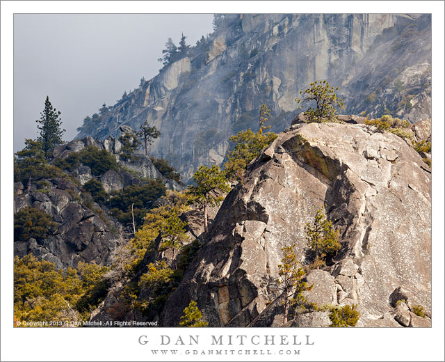
Tag Archives: mountains

Juniper, Red Rock, La Sal Mountains

Juniper, Red Rock, La Sal Mountains - A Utah juniper growing on red rock with the La Sal Mountains in the distance, Grand View overlook, Canyonlands National Park
A Utah juniper growing on red rock with the La Sal Mountains in the distance, Grand View overlook, Canyonlands National Park

Juniper, Red Rock, La Sal Mountains. Canyonlands National Park, Utah. October 10, 2012. © Copyright 2012 G Dan Mitchell – all rights reserved.

A Utah juniper growing on red rock with the La Sal Mountains in the distance, Grand View overlook, Canyonlands National Park.

We had a great visit to Canyonlands National Park, though the lighting was challenging, to say the least. Our visit took us up to the “island in the sky” highlands and included a stop at the Dead Horse Point State Park. Initially, the light challenges were simply from the midday light and the fact that there was a certain amount of haze in the air. The haze can be a nice effect in some cases, but it can also obscure some of the longer views such as those from this high plateau. As the day wore on, clouds began to collect to the west and, as luck would have it, the thickest portion of the clouds were almost directly west of us. Ultimately, this interfered with my chances for dusk shooting, but sometimes that’s just the way it goes.

Before heading to the golden hour light location that I had selected, we drove down to the “Grand View” overlook – appropriately named, as anyone who has been there can confirm. Here the high plateau ends suddenly with a steep thousand foot drop off to the next lower level of strata and the Green River joins the Colorado in the vast and rugged terrain to the south. I did eventually make some photographs of that subject – it is sort of obligatory! However, as I walked to the overlook I saw to my left this chunk of cliff-edge sandstone with its resident juniper and remembered looking at it the last time I was there. The soft light produced by the overcast was a Good Thing here, as full sun would have produced a very harsh effect on the rocks. Beyond lies the giant valley of the Colorado River and even further out are the high and distant peaks of the La Sal mountains.

G Dan Mitchell is a California photographer whose subjects include the Pacific coast, redwood forests, central California oak/grasslands, the Sierra Nevada, California deserts, urban landscapes, night photography, and more.
Blog | About | Flickr | Twitter | FacebookGoogle+ | 500px.com | LinkedIn | Email

Text, photographs, and other media are © Copyright G Dan Mitchell (or others when indicated) and are not in the public domain and may not be used on websites, blogs, or in other media without advance permission from G Dan Mitchell.

Sunset, Chessman Point, Cedar Breaks

Sunset, Chessman Point, Cedar Breaks
S”Sunset, Chessman Point, Cedar Breaks” — unset light at Chessman Point, Cedar Breaks National Monument

This was my first visit to Cedar Breaks National Monument in Utah. On my previous trip though Utah we had driven past the roads leading to Cedar Breaks and – doing what one does while driving these days! – we looked it up on the iPhone, and it sounded quite interesting. The descriptions suggested a high elevation bowl with Bryce Canyon-like features that would be open to the west and sunset light. With this in mind, we decided to end our cross-Nevada drive with an overnight at Brian Head, the seasonally dormant ski area where rooms were both relatively inexpensive and quite nice! After checking in we drove on up the road to the National Monument.

The terrain is very interesting and very “not California” to this Sierra Nevada guy. On one side of the ridge is a gently rolling high terrain of alternative forest and meadows, just the sort of place to find lots of deer in the evening and an altogether quiet and peaceful sort of place. On the other side of the ridge, however, things are quite different. The mountain simply drops away to the west, with brightly colored and complex fluted canyons of red rock and soil. Far below and in the distance we could see large groves of aspen trees. A strong wind was blowing up the west-side canyons, but I managed to stabilize things enough to make a few photographs of this spectacular terrain in near-dusk light.


Leave a comment or question using the form. (If you are reading this on the home page, click the article title to see the full article and the comment form.

G Dan Mitchell is a California photographer and visual opportunist. His book, “California’s Fall Color: A Photographer’s Guide to Autumn in the Sierra” (Heyday Books) is available directly from him. Blog | Bluesky | Mastodon | Substack Notes | Flickr | Email

All media © Copyright G Dan Mitchell and others.

Big Sur Coast at Soberanes Point

Big Sur Coast at Soberanes Point - Evening fog comes in as the rugged Big Sur coast stretches north from near Soberanes Point, California
Evening fog comes in as the rugged Big Sur coast stretches north from near Soberanes Point, California

Big Sur Coast at Soberanes Point. Big Sur, California. August 13, 2012. © Copyright 2012 G Dan Mitchell – all rights reserved.

Evening fog comes in as the rugged Big Sur coast stretches north from near Soberanes Point, California.

Talk about photographic geekiness – we ended up making photographs on my birthday! Because of a variety of factors, this turned out to be a bit of a low key birthday this year – despite some earlier plans to do all sorts of wild and crazy things. (Completing the JMT or going to Alaska will perhaps wait a bit… ;-) After a quiet and lazy morning we decided to head down to the Monterey area for a birthday dinner, which turned out to be quite nice by the way. (Thanks, Patty!)

Since we arrived a few hours before our dinner reservation. After stalling around a bit, thinking about this and that option, we decided to do the usual, obvious thing and head south on the Highway 1, the “coast highway,” into the upper portion of the Big Sur coastline area. While it is a very familiar area and one I visit a lot, it is never the same twice – all of the variables of light and atmosphere and season and weather are in play and you almost never know quite what you’ll find. On this early evening, the most important factor was that the edge of the ocean fog was positioned very close to the shore. This meant that sometimes it extended just a bit inland, creating light that ranged from slightly luminous to gray and murky, while in other areas it was just offshore, allowing light to hit the coast and even to light the surface of the ocean a bit. Here at the cove where the creek comes down Soberanes Canyon to meet the ocean, we found one of those boundaries – quite gray along the immediate coast in the distance, sunlight on the bluffs and hills at the right, and that wonderful boundary light in between. And above that, the barely perceptible difference between the soft clouds of fog and the light blue of the late-day sky.

G Dan Mitchell is a California photographer whose subjects include the Pacific coast, redwood forests, central California oak/grasslands, the Sierra Nevada, California deserts, urban landscapes, night photography, and more.
Blog | About | Flickr | Twitter | FacebookGoogle+ | 500px.com | LinkedIn | Email

Text, photographs, and other media are © Copyright G Dan Mitchell (or others when indicated) and are not in the public domain and may not be used on websites, blogs, or in other media without advance permission from G Dan Mitchell.

Three Towers, Morning

Three Towers, Morning - Three tufa towers in morning light, surrounded by wind-blown patterns on the surface of Mono Lake, California.
Three tufa towers in morning light, surrounded by wind-blown patterns on the surface of Mono Lake, California.

Three Towers, Morning. Mono Lake, California. July 14, 2012. © Copyright 2012 G Dan Mitchell – all rights reserved.

Three tufa towers in morning light, surrounded by wind-blown patterns on the surface of Mono Lake, California.

In mid-July I was in the Tuolumne/Tioga Pass area of the Sierra for a few days of photograph. In the end, I decided to stay over one extra night so that I could drive down to photograph around Mono Lake early in the morning before heading home. I was up before dawn, quickly in my car, and down to the shoreline of Mono Lake before sunrise. My first objective was to try to photograph sand tufa formations – not the more famous tufa towers. I found what I was looking for, and spend the sunrise period photographing them in first light. However, this opportunity quickly ended, so I turned my attention to the lake itself, along with its surroundings of low hills.

While the tufa towers are the iconic visual symbols of Mono Lake, I have some other and perhaps strong associations with the place. Most of them are connected to a time of day, early morning, when I most often visit. They involve near silence, broken only by the sounds of the many gulls and other birds that are found in and around the lake. In my memories, the air is still, and it is warm, the warm of early an early desert morning that holds the smell of sage and dust. And while the moment of sunrise is what I often go there to find, in the end it is the light that comes a bit later that sticks most in my mind. This light is bright – almost too bright to look into if the lake is hazy – and it is blue with distance. This is the light that I saw on this morning, with a bit of very light breeze forming slight patterns on the surface of the lake near three isolated tufa towers.

G Dan Mitchell is a California photographer whose subjects include the Pacific coast, redwood forests, central California oak/grasslands, the Sierra Nevada, California deserts, urban landscapes, night photography, and more.
Blog | About | Flickr | Twitter | FacebookGoogle+ | 500px.com | LinkedIn | Email

Text, photographs, and other media are © Copyright G Dan Mitchell (or others when indicated) and are not in the public domain and may not be used on websites, blogs, or in other media without advance permission from G Dan Mitchell.