
Tag Archives: peak

Tungsten Hills, Buttermilk Country, and the Sierra Crest

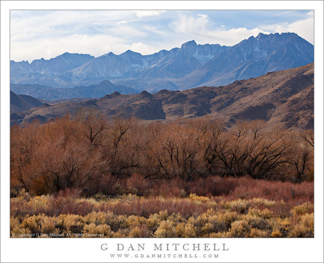
Tungsten Hills, Buttermilk Country, and the Sierra Crest - Layers of terrain including Owens Valley sagebrush, the Tungsten Hills, Buttermilk Country, and the Sierra Crest including Basin Mountain, Mount Humphreys, and Mount Emerson
Layers of terrain including Owens Valley sagebrush, the Tungsten Hills, Buttermilk Country, and the Sierra Crest including Basin Mountain, Mount Humphreys, and Mount Emerson

Tungsten Hills, Buttermilk Country, and the Sierra Crest. Round Valley, California. January 2, 2012. © Copyright 2012 G Dan Mitchell – all rights reserved.

Layers of terrain including Owens Valley sagebrush, the Tungsten Hills, Buttermilk Country, and the Sierra Crest including Basin Mountain, Mount Humphreys, and Mount Emerson.

In some ways this is a very typical eastern Sierra Nevada scene but in others, some of which might not be immediately obvious, it is atypical. I made the photograph while on my way to Death Valley in early January 2012. I had done the long drive over Tioga Pass (a first hint about the “unusual” issue) and was headed south to where I would turn east to cross the Inyo Range to that park. As I descended the long grade from Tom’s Place toward Bishop I passed through familiar Round Valley, but this little scene of sagebrush, Sierra foothills, and the crest caught my attention so I quickly stopped and made a few photographs.

The first and primary unusual thing about this photograph is that this was January! In a typical January the peaks here would be completely buried in winter snows – but this January the snowpack brought to mind mid-July. Although the season had started with early and heavy snows in October, things came to an abrupt halt and at this point it had been a month since real snow had fallen. A second slightly unusual thing is that I made this photograph in the mid-afternoon time frame. This is not a time typically regarded as being conducive to landscape photography. However, the high backlight was making the bluish haze more visible and the light was softened a bit by the high clouds, so I went ahead and made a photograph that, I hope, captures the somewhat harsh and dry conditions of the area and the season.

G Dan Mitchell is a California photographer whose subjects include the Pacific coast, redwood forests, central California oak/grasslands, the Sierra Nevada, California deserts, urban landscapes, night photography, and more.
Blog | About | Flickr | Twitter | FacebookGoogle+ | 500px.com | LinkedIn | Email

Text, photographs, and other media are © Copyright G Dan Mitchell (or others when indicated) and are not in the public domain and may not be used on websites, blogs, or in other media without advance permission from G Dan Mitchell.
First Light, Base of Tucki Mountain and the Panamint Range

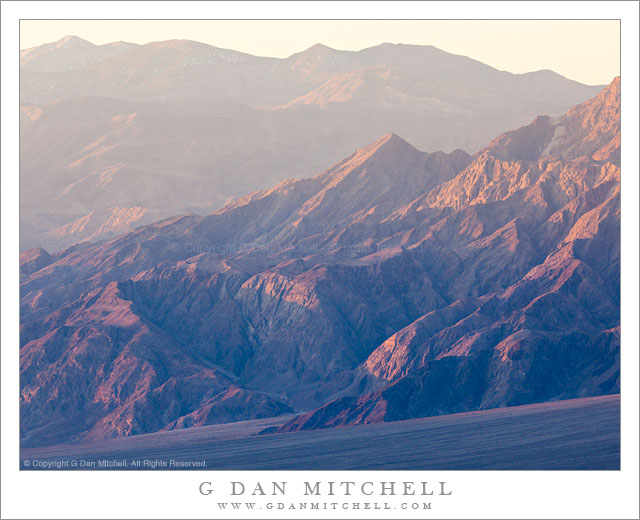
First Light, Base of Tucki Mountain and the Panamint Range - First morning light on the rugged landscape of the base of Tucki Mountain and the Panamint Range, Death Valley National Park, California
First morning light on the rugged landscape of the base of Tucki Mountain and the Panamint Range, Death Valley National Park, California

First Light, Base of Tucki Mountain and the Panamint Range. Death Valley National Park, California. January 3, 2012. © Copyright 2012 G Dan Mitchell – all rights reserved.

First morning light on the rugged landscape of the base of Tucki Mountain and the Panamint Range, Death Valley National Park, California

This photograph was made from a location a ways up from the bottom of Death Valley, from which I could look directly across at the lower slopes of gigantic Tucki Mountain as the first morning light worked its way down toward the lower ridges and the huge alluvial fan at the base of the mountain. At the moment I made the exposure the light was just beginning to fill this slanting area below the rugged mountains, and the light was softened by morning haze.

Tucki Mountain is a huge peak that almost seems to me to be large enough to count as its own minor mountain range. It rises above Stovepipe Wells, and extends a great distance east, south, and west of there. It is laced with deep canyons and its lower slopes are heavily eroded to reveal tilting and twisting strata. Another large valley lies on beyond the foreground spur ridge in this photograph, and beyond that the Panamint Range rises to its crest at 11,000+’ Telescope Peak.

G Dan Mitchell is a California photographer whose subjects include the Pacific coast, redwood forests, central California oak/grasslands, the Sierra Nevada, California deserts, urban landscapes, night photography, and more.
Blog | About | Flickr | Twitter | FacebookGoogle+ | 500px.com | LinkedIn | Email

Text, photographs, and other media are © Copyright G Dan Mitchell (or others when indicated) and are not in the public domain and may not be used on websites, blogs, or in other media without advance permission from G Dan Mitchell.
Rhyolite Ghost Town, Amargosa Valley and Mountains

Rhyolite Ghost Town, Amargosa Valley and Mountains
“Rhyolite Ghost Town, Amargosa Valley and Mountains” — The ruins of the ghost town of Rhyolite, Nevada stand above the Amargosa Valley, with the Amargosa Range and Death Valley National Park in the distance.

While there can be some moments of beautiful and colorful sunrise light at the ghost town of Rhyolite, Nevada – and I was there for it – this early morning light from a short time later probably gives a more true sense of what the place tends to look like during the winter months. (Even here, the high, thin clouds soften the scene a bit – it is often quite cloudless.)

From what I understand, Rhyolite sprang up in the very early 1900s after gold was discovered nearby. During the short life of the town, measured in no more than decades, it was reportedly the second largest city in southern Nevada. It featured banks (two of which are seen in this photograph), a railroad station (abandoned but still present and located behind my camera position), newspapers, an impressive school house, and thousands of residents. It was all largely abandoned in the first half of the 1900s and most of the buildings are gone, though traces of them and the old roads they lined can still be found here and there. A few large buildings in the center of the town still more or less stand, in varying states of decay. The building on the right was the Cook Bank. Another bank was located where the white walls are a bit further in the distance. The town school house is the furthest building. The whole town overlooked the Amargosa Valley, where the current boundary of Death Valley National Park lies. Beyond that, an inside the park, are the Amargosa Range and in the far distance the ridge of the Panamint Range and the summit of 11,000+’ Telescope Peak.


G Dan Mitchell is a California photographer and visual opportunist. His book, “California’s Fall Color: A Photographer’s Guide to Autumn in the Sierra” (Heyday Books) is available directly from him.

G Dan Mitchell: Blog | Bluesky | Mastodon | Substack Notes | Flickr | Email


All media © Copyright G Dan Mitchell and others as indicated. Any use requires advance permission from G Dan Mitchell.

Eureka Dunes and Last Chance Range, Morning

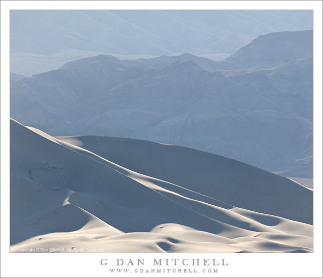
Eureka Dunes and Last Chance Range, Morning - Morning light on the Eureka Dunes and the hills of the Last Chance Range, Death Valley National Park.
Morning light on the Eureka Dunes and the hills of the Last Chance Range, Death Valley National Park.

Eureka Dunes and Last Chance Range, Morning. Death Valley National Park, California. January 6, 2012. © Copyright 2012 G Dan Mitchell – all rights reserved.

Morning light on the Eureka Dunes and the hills of the Last Chance Range, Death Valley National Park.

While I love – who doesn’t? – the golden hour light on the desert dunes and hills and valleys, I also like to seek out the subtler and more “atmospheric” effects that are often frequently seen in this terrain. I had spent the (very cold!) night alone out here in Eureka Valley. I woke up fairly early, though with the sun having to rise past the ridge of the Last Chance Range, the light did not come early. I soon packed up my camp – which largely meant rearranging stuff in my vehicle – and before long started the drive out toward Lone Pine and my trip back home over Tioga Pass.

But first I planned to stop just a ways away from the camping area so that I could use a long lens to photograph the dunes against the background of the higher surrounding peaks. By the time I did this it was after 9:00 a.m. and the early morning golden hour light was long gone, replaced by the soft and hazy bluish light that is more typical during daylight hours. However, the sun was still low enough to glance across the dunes at a fairly low angle and to backlight the dunes and the mountains behind them. The idea here was to juxtapose some of the different textures, lines, curves, and angles of this landscape – the curving forms of the dunes near the bottom of the frame, the sharply delineated sunlit ridges of the upper dunes, the faint view of jagged and stratified rocks in the low peaks beyond them, the further ridge inclining the opposite direction from the dunes, and the much fainter texture of the huge valley in the distance.

G Dan Mitchell is a California photographer whose subjects include the Pacific coast, redwood forests, central California oak/grasslands, the Sierra Nevada, California deserts, urban landscapes, night photography, and more.
Blog | About | Flickr | Twitter | FacebookGoogle+ | 500px.com | LinkedIn | Email

Text, photographs, and other media are © Copyright G Dan Mitchell (or others when indicated) and are not in the public domain and may not be used on websites, blogs, or in other media without advance permission from G Dan Mitchell.