A trail weaves through meadow and among sub-alpine ponds at Artist Point with the ridge of Mt. Shuksan beyond – Mt. Baker-Snoqualmie National Forest, Washington.
This is another photograph from my late-August afternoon exploration of the stunning ridgeline of Artist Point in the Mt. Baker-Snoqualmie National Forest near the Mt. Baker ski area. This ridge runs through an intimate landscape comprised of small rock fields, meadows with running streams, groves and isolated high elevation trees, and small ponds – and provides a truly stunning panorama that takes in Mount Baker on one side and Mount Shuksan on the other, with distant peaks all around. We could hardly have asked for better conditions for late-afternoon photography. Dramatic clouds ringed the peaks, sometimes obscuring them and sometimes clearing for a moment, and bright sun alternated with softer and diffused light as cloud shadows moved across the ridge.
A bit further along the ridge there is a series of small snow-melt lakes – what I usually refer to as “tarns” in the Sierra. Here a trail winds in front of a couple of them that sit in rocky hollows in front a few ridgeline trees, with the cloud-shrouded shoulder of glacier-covered Mount Shuksan beyond.
This photograph is not in the public domain and may not be used on websites, blogs, or in other media without advance permission from G Dan Mitchell.
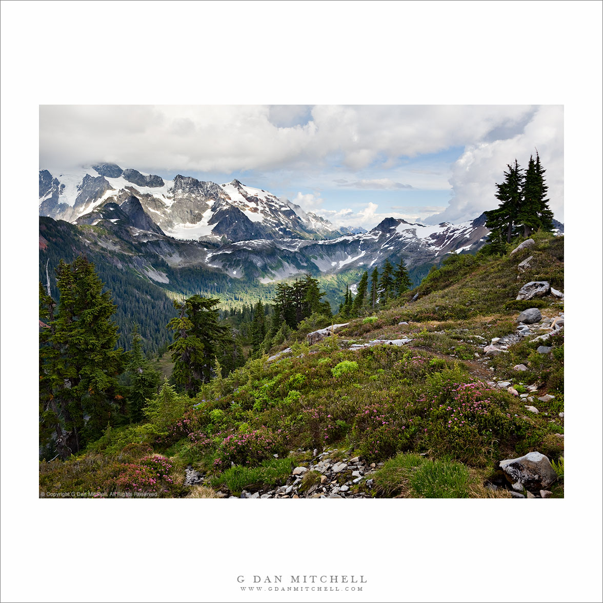
“Artist Point Meadow, Mount Shuksan” — The view of cloud-shrouded Mount Shuksan from a heather-filled sub-alpine meadow at Artist Point, Mt. Baker-Snoqualmie National Forest, Washington.
As my brother and I came around the corner of this trail along the side of the Artist Point ridge, it took our breath away. I arrived a moment after he did, and found him already down among the heather flowers near the small run-off creek setting up his tilt-shift lens to make a close-up photograph of the flowers with the mountains in the distance. Once he finished, I went to work on this wider view of the scene, including the nearby foreground meadow and flowers, the trees along the edge of the drop-off, the pool of light in the valley beyond, and the shoulder of cloud-rimmed Mt. Shuksan with a dramatic sky beyond.
On a technical note, this was a very difficult exposure. When I looked down at the flowers and plants I saw what you see here, and when I looked up I saw the cloud-filled sky roughly as it appears in this photograph – but the dynamic range was so wide (ranging from parts of the foreground trees in deep shadow to distant snow fields in direct sun) that one exposure could not capture all of the scene data… so I used three which were then combined in post using masked layers and blended manually.
G Dan Mitchell is a California photographer and visual opportunist. His book, “California’s Fall Color: A Photographer’s Guide to Autumn in the Sierra” is available from Heyday Books, Amazon, and directly from G Dan Mitchell.
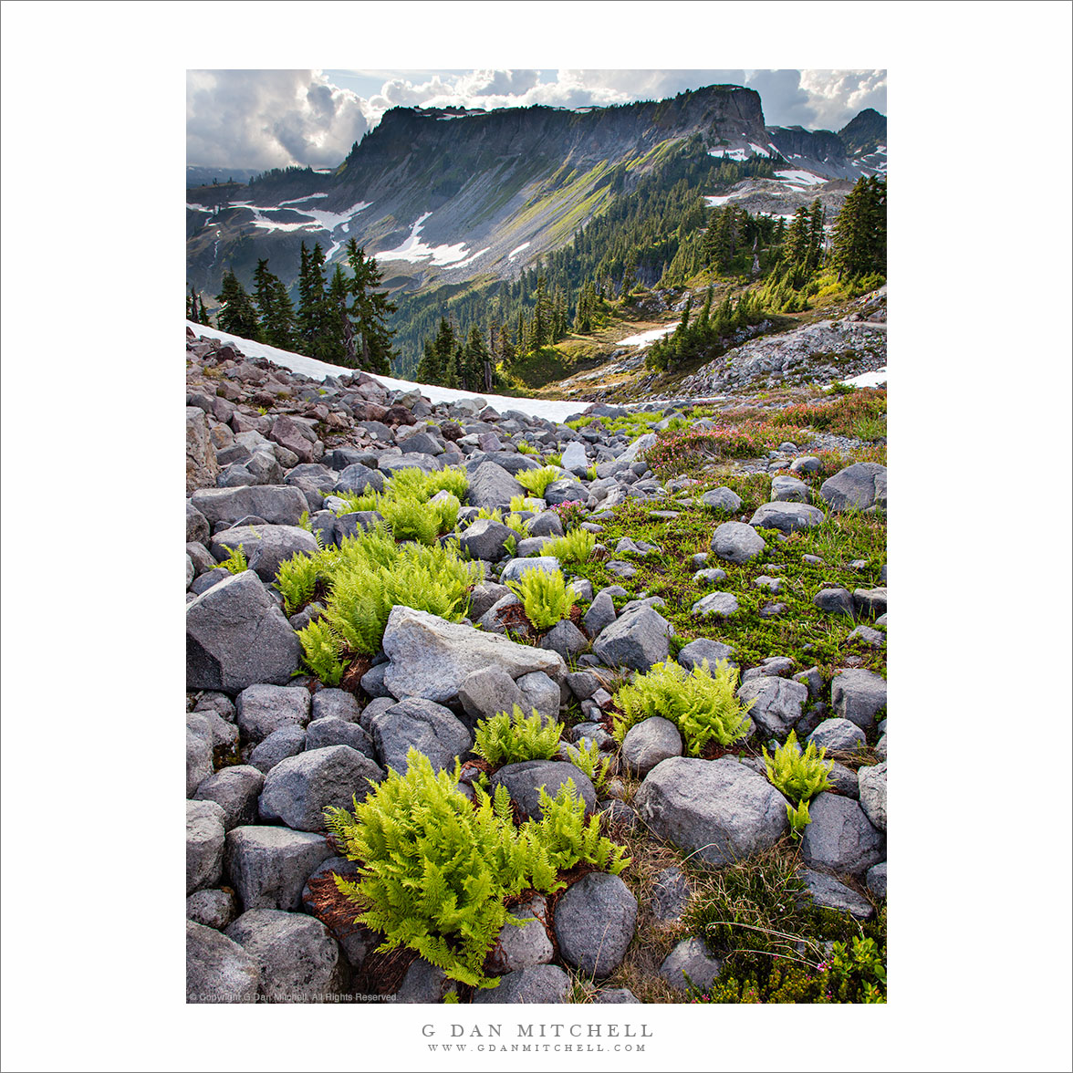
“Ferns and Rocks, Artist Point” — Ferns grow among the rocks of a sub-alpine talus field at Artist Point, Mt. Baker-Snoqualmie National Forest, Washington.
I have (barely) visited parts of the Cascades range of Washington, but it was some years ago and I did not make photographs at the time. This past week I finally had an opportunity to do some real photography in this spectacular mountain range when I accompanied my brother (Richard Mitchell to the Mt. Baker-Snoqualmie National Forest where we visited Artist Point, a spectacular sub-alpine ridge located between the peaks of Mt. Baker and Mt. Shuksan.
As a long time “Sierra guy” (who has probably spent a total of over two years of his life on the trail in that range) I compare everything to my “home range.” While the Sierra is (are?) in my blood and that isn’t likely to change any time soon, these Washington mountains have (as Washington residents know) a lot to offer. The first thing that I noticed – though you won’t see it in this photograph – is that you quickly get up close and personal with some very large and impressive ice fields and glaciers. In the Sierra we see small glaciers, but they are tame compared to the hulking monsters of the Cascades. As we approached this area and I caught my first view of Shuksan the glaciers were the first thing that I noticed. In addition, you reach sub-alpine and alpine terrain at much lower elevations than in the Sierra. The 5,000’+ area where we photographed felt like a about 10,000′ in the Sierra.
I made this photograph near the end of our visit to Artist Point, in the very late afternoon as the sun dropped and the light began to warm and back-light these plants. These ferns were growing among the rocks of a talus field alongside the trail. There is a little lesson in how this photograph came about. A few hours earlier we had walked past this little area of ferns and rocks and I had paused for some minutes, trying in vain to find a composition there that worked. I knew that there was something about it that was interesting, but I just could not “see” it at that earlier hour. (I’m blaming the light! :-) So we moved on and spend good, productive time photographing in beautiful areas further along the trail. Eventually we realized that we had stayed longer than planned, and that if we were to make it to another site that we had scoped out for golden hour photography we had to high-tail it back down to the parking lot. We loaded up and began the dash down the trail. As I sped past this section, something momentarily caught my attention and brought me up short. Coming back down the trail and now in light that had changed a great deal, I saw photographic potential in the subject that I had not been able to find before – so I stopped and made this photograph.
Leave a comment or question using the form. (If you are reading this on the home page, click the article title to see the full article and the comment form.
Evening sky over the Great Western Divide reflected in an unnamed alpine lake, Sequoia National Park, California.
I don’t know quite what to say about this area of the Sierra located just east of the Great Western Divide in the upper reaches of the Kern River drainage – I’ve been very close to here on many previous trips, but I never quite managed to hop the intervening ridge even though I’ve thought vaguely about visiting this area for decades and I once passed through the lower reaches of it, more or less by accident and completely unaware of what was just upstream.
A group of us traveled over Kearsarge Pass (11,700’+) and Forrester Pass (13, 200′) to arrive in the upper Kern at Tyndall Creek along the JMT. (I think the general area is also known as the “bighorn plateau.”) I’ve been here on several previous occasions while heading to or circumnavigating Mt. Whitney. While I’ve gone east (to exit over the very rough Shepherd Pass at 12,000′) I’ve not really explored west and north of this area. Our general plan on this trip was to rectify that, specifically by visiting remote and very high Lake South America. After wandering up a mosquito-infested valley, climbing its headwall, and then dropping to a lake just below the saddle we made it to Lake South America. We had originally planned to stay here overnight, but the very barren and rocky surroundings didn’t attract us in the end, so we decided to head on to the west and south.
After a bit of a walk on a somewhat rough trail (which got much rougher later on) we arrived at a series of timberline lakes overlooking the Great Western Divide, which towered above us to the west. There is much I could say about this area, but I’ll limit myself to a few comments… and not name the specific location we visited. We finally found a sandy camping spot between a few lakes and tarns – it was surrounded by stunning alpine views ranging from the lakes themselves and the surrounding rocky meadows and clumps of trees to the jagged and high peaks to our west. The next morning we followed a very faint trail down the canyon, passing almost continuously through astonishing scenery featuring intimate, granite-surrounded meadows and small lakes.
I must go back. It won’t be easy. I’ll want to carry a bit more photography gear than I carried on this trip, and I’ll want to stay a day or two longer. And the location is two to three days from the nearest trailheads, all of which take you over some very high passes.
This photograph is not in the public domain and may not be used on websites, blogs, or in other media without advance permission from G Dan Mitchell.
(Basic EXIF data is available by “mousing over” large images in blog posts. Leave a comment if you want to know more.)
Photographer and visual opportunist. Daily photos since 2005, plus articles, reviews, news, and ideas.
Manage Consent
To provide the best experiences, we use technologies like cookies to store and/or access device information. Consenting to these technologies will allow us to process data such as browsing behavior or unique IDs on this site. Not consenting or withdrawing consent, may adversely affect certain features and functions.
Functional
Always active
The technical storage or access is strictly necessary for the legitimate purpose of enabling the use of a specific service explicitly requested by the subscriber or user, or for the sole purpose of carrying out the transmission of a communication over an electronic communications network.
Preferences
The technical storage or access is necessary for the legitimate purpose of storing preferences that are not requested by the subscriber or user.
Statistics
The technical storage or access that is used exclusively for statistical purposes.The technical storage or access that is used exclusively for anonymous statistical purposes. Without a subpoena, voluntary compliance on the part of your Internet Service Provider, or additional records from a third party, information stored or retrieved for this purpose alone cannot usually be used to identify you.
Marketing
The technical storage or access is required to create user profiles to send advertising, or to track the user on a website or across several websites for similar marketing purposes.


