Tag Archives: snow

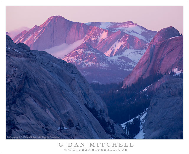
Last Light, Mount Conness

Last Light, Mount Conness

Last Light, Mount Conness. Yosemite National Park, California. June 18, 2011. © Copyright G Dan Mitchell – all rights reserved.

The final evening alpenglow illuminates the summit ridge of Mount Conness and the west face of Medlicott Dome in the Yosemite National Park high country.

This will be my final photograph of Mount Conness from the evening of June 18, the day that Tioga Pass Road opened this year and the day of one of the most spectacular Yosemite high country sunsets in recent memory. It will be the final both in the sense that I think I’ve now shared the best of the group of images of this sunset and in the sense that it was literally my final exposure of the evening.

The short back-story is that what started out as a fairly unimpressive evening (at least in the photographic sense) transformed over a short period into something extraordinary as the sun dropped to the horizon west of the Sierra and illuminated the clouds from below, creating rare and very special alpenglow conditions over a wide area of the Sierra. (During the week that followed quite a few people commented on this amazing light, which they had witnessed from locations as distant as Mono Lake on the east side and the Central Valley to the west.)

When I made this photograph the show was coming to an end. At this point the sun had already set a few minutes earlier – the exposure was made around 8:45 p.m. – and the light was low enough to require a six-second exposure. While it may seem like Mount Conness (the tallest peak near the left on the skyline) and other features are receiving direct sunlight, this is actually the remaining post-sunset glow in the western sky.

G Dan Mitchell Photography
Flickr | Twitter (follow me) | Facebook (“Like” my page) | 500px.com | LinkedIn | Email

Text, photographs, and other media are © Copyright G Dan Mitchell (or others when indicated) and are not in the public domain and may not be used on websites, blogs, or in other media without advance permission from G Dan Mitchell.

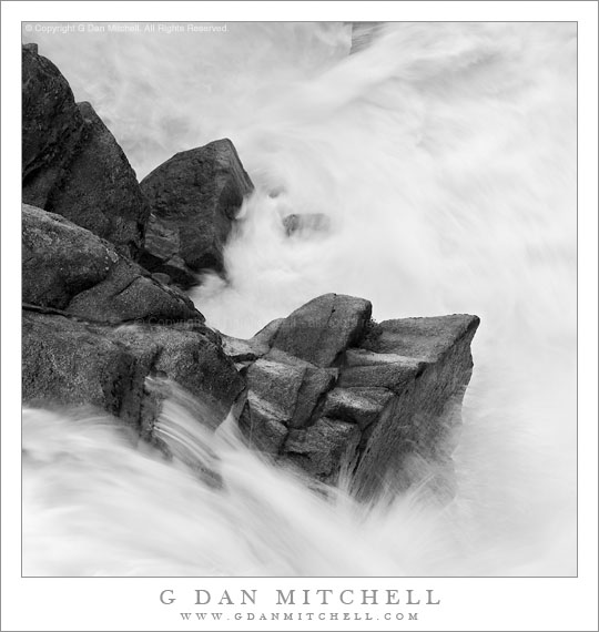
Boulders, Cascade Creek

Boulders, Cascade Creek

Boulders, Cascade Creek. Yosemite National Park, California. June 18, 2011. © Copyright G Dan Mitchell – all rights reserved.

Granite boulders deflect the turbulent flow of Cascade Creek as it descends to the Merced River, Yosemite National Park.

This photograph is another in my continuing study of the boulders and flowing water of Yosemite’s Cascade Creek. I made this photograph fairly early in the morning on the weekend when Tioga Pass opened this year. I arrived before the scheduled 8:00 a.m. opening of Tioga Pass Road and decided that it would be more interesting and useful to photograph this subject than to wait in line so that I could be on my way over the pass at exactly the moment the road opened, especially when the morning brings shaded, diffused light to this cascade.

As I repeatedly photograph this subject, I begin to know it much more thoroughly. Partly it is a matter of understanding the seasonal and even daily ebb and flow of water and light at this place, but it is also a process of becoming very familiar with smaller details of the scene. When I first photographed here this rock outcropping was something that I occasionally worked to minimize in some compositions, but it has since come to be an interesting subject on its own. It extends into the torrent, forcing the water to flow around (and partially over, in high water) before dropping steeply to the right, running into other rocks, and making a quick and turbulent left turn before heading over another drop. Because it sits in the middle of all of this wild water, it is often covered with water and this water reflects the light of the open sky beyond the shaded confines of this narrow canyon.

G Dan Mitchell Photography
Flickr | Twitter (follow me) | Facebook (“Like” my page) | LinkedIn | Email

Text, photographs, and other media are © Copyright G Dan Mitchell (or others when indicated) and are not in the public domain and may not be used on websites, blogs, or in other media without advance permission from G Dan Mitchell.

Pywiack Dome, Tenaya Creek in Flood

Pywiack Dome, Tenaya Creek in Flood

Pywiack Dome, Tenaya Creek in Flood. Yosemite National Park, California. June 19, 2011. © Copyright G Dan Mitchell – all rights reserved.

Pywiack Dome towers above Tenaya Creek as it floods surrounding meadows with spring snow melt, Yosemite National Park.

This little spot between Pywiack Dome and Tenaya Lake has interested me for some time. Driving past, I’ve been intrigued by the dome itself (of course!) but also by the small meadow below it where Tenaya Creek winds through a mixture of forest and meadow, and from which the outlet of Cathedral Lake is visible if you know just where to look. In the past, I’ve wandered about in this meadow a bit, trying to photograph lush growth of corn lily plants early in the season.

On this visit, as I drove by on the first day, I was struck by the amount of water flowing here – what I’m used to seeing as a meadow with a stream winding through it was filled from edge to edge with rushing water from snowmelt-swollen Tenaya Creek. I made a mental note to try to come back here the following morning when I thought that light might be interesting. And that’s just what I did on the second day of this visit during the weekend when the pass opened.

G Dan Mitchell Photography
Flickr | Twitter (follow me) | Facebook (“Like” my page) | LinkedIn | Email

Text, photographs, and other media are © Copyright G Dan Mitchell (or others when indicated) and are not in the public domain and may not be used on websites, blogs, or in other media without advance permission from G Dan Mitchell.

Mount Gibbs, Frozen Pond, Morning

Mount Gibbs, Frozen Pond, Morning

Mount Gibbs, Frozen Pond, Morning. Yosemite National Park, California. June 19, 2011. © Copyright G Dan Mitchell – all rights reserved.

Dawn light on the snow-capped summit of Mount Gibbs above a frozen pond, Yosemite National Park.

This small pond is perhaps familiar to visitors to Tuolumne Meadows and Tioga Pass, though more likely with a different appearance. Here, early on a cold morning on the day after Tioga Pass opened for the season, the pond is still mostly frozen and it is surrounded by deep snow banks. The summit of Mount Gibbs is just touched by the first morning light as it passes through clouds over the Sierra crest.

G Dan Mitchell Photography | Flickr | Twitter (follow me) | Facebook (“Like” my page) | LinkedIn | Email
Text, photographs, and other media are © Copyright G Dan Mitchell (or others when indicated) and are not in the public domain and may not be used on websites, blogs, or in other media without advance permission from G Dan Mitchell.