Tag Archives: water

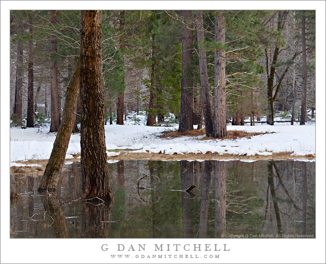
Forest and Pond, Winter

Forest and Pond, Winter

Forest and Pond, Winter. Yosemite Valley, California. January 16, 2010. © Copyright G Dan Mitchell – all rights reserved.

Trees grow out of a small winter melt-water pool in Yosemite Valley, California.

As I drove down the Valley I spotted this very quiet seasonal pool that was reflecting the forms of the forest trees in the soft late-afternoon light. As the temperature dropped there was just the slightest hint of shallow fog starting to form above the surface of the water.

If you are the type who reads the “technical data” accompanying the photos you perhaps notice the unusual choice of lens for this photograph. You might also be surprised at just how often I use a long lens, even this 100-400 zoom, for landscape subjects. Besides getting me “closer” to subjects that would otherwise be out of reach – that was the case here where there was water between me and the trees – the longer lenses also compress the contents of the scene and can also help eliminate elements that would otherwise distract from the main scene.

This photograph is not in the public domain and may not be used on websites, blogs, or in other media without advance permission from G Dan Mitchell.

G Dan Mitchell Photography
FlickrTwitter (follow me) | Facebook (“Like” my page) | LinkedInEmail

Text, photographs, and other media are © Copyright G Dan Mitchell (or others when indicated) and are not in the public domain and may not be used on websites, blogs, or in other media without advance permission from G Dan Mitchell.

Rope Across Horsetail Fall?

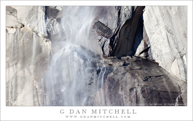
Photographing Horsetail Fall has increasingly become “the thing to do” in Yosemite Valley for quite a few photographers this time of year. Horsetail is a seasonal waterfall that drops from near the eastern end of El Capitan in Yosemite Valley, and for a few weeks each winter may catch the setting sun to produce quite a visual show when the conditions are just right. I’m not going to offer a how-to for photographing Horsetail – good ones are available elsewhere, and as beautiful as the sight can be, I have a sort of “been there, done that” attitude towards it at this point.

Which is not to say that I won’t point my camera that direction if I find myself in the area! I did so for a few minutes last weekend, even though it was well before the time when the sunset show begins, and even though it was the middle of the afternoon. I happened to be photographing something else below the fall and after I finished I looked up and noticed that the flow of water over Horsetail was as strong as I’ve seen it. I had a long lens on the camera, so I pointed it up and made a few photographs.

Here is the odd thing… In the photographs made with this telephoto lens I can clearly see that a long climbing rope ascends from the right to the first ledge that the water hits, crosses the ledge, and continues its ascent to the left of the fall. It appears to be a fixed rope that someone left in place, and I can only wonder about possible explanations. Did someone have to leave it behind earlier in the season? Did someone leave it with the intention of coming back and traversing through the fall?

If it does remain much longer, there may be some disappointed photographers who find a glowing rope draped across their photographs of the fall this season…

Fixed Rope Across Horsetail Fall

Fixed Rope Across Horsetail Fall. Yosemite Valley, California. January 16, 2011. © Copyright G Dan Mitchell – all rights reserved.

This photograph is not in the public domain and may not be used on websites, blogs, or in other media without advance permission from G Dan Mitchell.
G Dan Mitchell Photography
FlickrTwitter (follow me) | Facebook (“Like” my page) | LinkedInEmail

Text, photographs, and other media are © Copyright G Dan Mitchell (or others when indicated) and are not in the public domain and may not be used on websites, blogs, or in other media without advance permission from G Dan Mitchell.

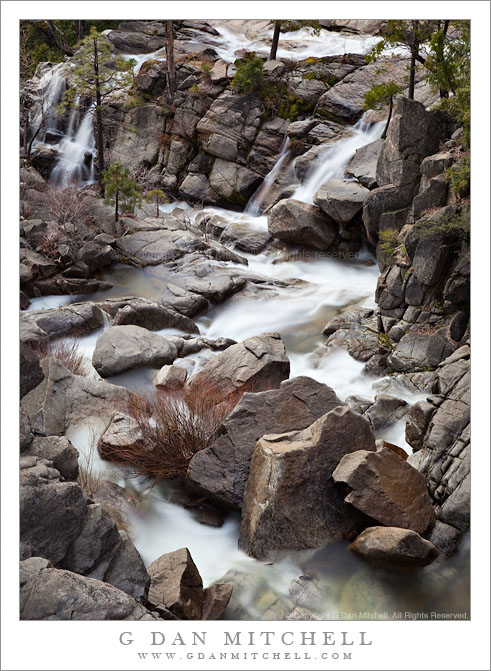
Confluence of Cascade and Tamarack Creeks

Confluence of Cascade and Tamarack Creeks

Confluence of Cascade and Tamarack Creeks. Yosemite National Park, California. January 16, 2011. © Copyright G Dan Mitchell – all rights reserved.

Long exposure in evening light of the boulder-strewn confluence of Cascade and Tamarack Creeks, Yosemite National Park.

Right below the bridge along the Crane Flat Road (often described as highway 120) route into Yosemite Valley, two wildly cascading creeks join together before their final descent to the bottom of the canyon where they join with the Merced River. Cascade Creek is probably the better known of the two since some spectacular sections of its descent are clearly visible right above the roadway. Tamarack Creek is easier to miss since you have to look carefully into the trees if you try to spot it from your car, or else get out of the car and look more closely. In the photograph, Cascade Creek flows away from the bottom of the frame, and Tamarack joins from the right in the upper portion of the frame.

I’ve always paid more attention to the section of Cascade Creek that is above the bridge. However, after recently having several opportunities to carefully (and admiringly) view Charlie Cramer’s stunning print of his “Cascade Creek, Spring, Yosemite”, I decided that I really needed to look off the other side of this bridge! (Charlie, I found your rocks. First, I’m even more impressed now that I realize how obscure and out of the way the subject of your photograph is. Second, how the heck did you position the camera over the side of the bridge to make that photograph!?) With that in mind, I visited this spot several times on this weekend trip to Yosemite and tried photographing it in different types of light.

This photograph is not in the public domain and may not be used on websites, blogs, or in other media without advance permission from G Dan Mitchell.

G Dan Mitchell Photography
FlickrTwitter (follow me) | Facebook (“Like” my page) | LinkedInEmail

Text, photographs, and other media are © Copyright G Dan Mitchell (or others when indicated) and are not in the public domain and may not be used on websites, blogs, or in other media without advance permission from G Dan Mitchell.


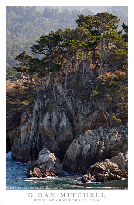
Monterey Cypress and Coastal Cliffs at Bluefish Cove

Monterey Cypress and Coastal Cliffs at Bluefish Cove

Monterey Cypress and Coastal Cliffs at Bluefish Cove. Point Lobos State Reserve, California. January 8, 2010. © Copyright G Dan Mitchell – all rights reserved.

Monterey Cypress trees grow atop cliffs above Bluefish Cove at Point Lobos State Reserve.

One fun thing about photographing places that I have visited for nearly my full life is that it sometimes encourages me to learn things about places that I had taken for granted – like names of features and places. Although I’ve been to Point Lobos since I was a child and I have seen this area of the reserve many times, I had no idea there was a place called Bluefish Cove, much less that this was it. More accurately, the small patch of water at the foot of this wonderful bit of rocky cliff and cypress forest is Bluefish Cove. I am surprised to note that the point itself seems to be unnamed, at least according to several maps I checked, each of which names many lesser places. The ridge rises from the water to form a peninsula between Bluefish Cove and the larger Whalers Cove. Beyond and above are some of the first coastal hills at what I think of as the north end of the Big Sur coastline.

This photograph is not in the public domain and may not be used on websites, blogs, or in other media without advance permission from G Dan Mitchell.

G Dan Mitchell Photography
FlickrTwitter (follow me) | Facebook (“Like” my page) | LinkedInEmail

Text, photographs, and other media are © Copyright G Dan Mitchell (or others when indicated) and are not in the public domain and may not be used on websites, blogs, or in other media without advance permission from G Dan Mitchell.