Tag Archives: bounder

Meadow, Snag, And Boulder

Meadow, Snag, And Boulder
An old snag lies across a boulder at the edge of an alpine meadow, John Muir Wilderness

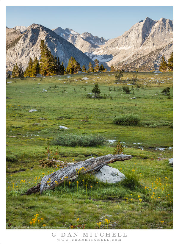
Meadow, Snag, And Boulder. © Copyright 2017 G Dan Mitchell – all rights reserved.

An old snag lies across a boulder at the edge of an alpine meadow, John Muir Wilderness.

This view looks across a high meadow, past an old snag resting on a boulder, across a low ridge covered with wildflowers, and towards a more distant ridge on the other side of the main canyon. It is, in many ways, a classic Sierra Nevada view. It is also a view of my favorite Sierra Nevada terrain — that land just below timberline where the forest of small trees opens more and more to the light, with meadows and granite areas providing open views of the surrounding peaks.

We (a group of photographers and fiends) were camped above a nearby lake for a week, spending out days in a combination of intense photography and the backcountry camaraderie that develops among such people in such places. This spot was perhaps a 15-20 minute walk from our camp, and we visited it often. On this day several of us were up before dawn and headed this way, intending to photograph the first light on mountains, meadows, and trees.


G Dan Mitchell is a California photographer and visual opportunist. His book, “California’s Fall Color: A Photographer’s Guide to Autumn in the Sierra” is available from Heyday Books and Amazon.

Blog | About | Flickr | FacebookEmail

Links to Articles, Sales and Licensing, my Sierra Nevada Fall Color book, Contact Information.


All media © Copyright G Dan Mitchell and others as indicated. Any use requires advance permission from G Dan Mitchell.

Sea Stacks, Big Sur Coastline

Sea Stacks, Big Sur Coastline

Sea Stacks, Big Sur Coastline. Pacific Coast Highway, California. May 13, 2011. © Copyright G Dan Mitchell – all rights reserved.

Sea stacks line the rugged California Big Sur coastline below the Pacific Coast Highway.

I had some free time on Friday morning, so I decided to head over to the coast below Monterey. I had some discussions with someone earlier this week about photographs featuring coastal fog and hills, and I think that may be what planted the idea in my mind, though it turned out that conditions were not quite ideal for that particular sort of thing. However, it was a beautiful spring morning along the Big Sur coast, with the bright sun somewhat modulated by some atmospheric haze and a bit of fog here and there along ridge tops.

For those who may not have heard, driving this section of the Coast Highway is a bit tricky right now due to washouts and closures. I had to wait for a pilot vehicle to lead scores of us through one large section, and in another spot the road was reduced to a single lane by a large landslide. I understand that further south the road is actually closed completely, necessitating an inland detour.

The unusual traffic situation did create one advantage for me, however. Usually there is enough traffic on this famous route that driving along at very slow speeds annoys other drivers – so I sometimes have to keep going right past places I might otherwise want to stop and investigate. However, yesterday I quickly figured out that with 20-30 minutes between waves of traffic as the road opened and closed, all I had to do was pull over after passing one of the blockages, wait for the other cars to pass, and then drive in a more leisurely way with plenty of opportunities to stop.

So as I drove past this area that I had not really looked at closely in the past – it is between a couple of other spots that I know well – I was able to drive slowly, pull over to look more carefully, backtrack, and generally get to see it more than in the past. I first pulled off near this spot simply to turn around to go back and check a spot I had just passed. As I did so I noticed a painter packing up his gear. I did my “turn around,” looked at the spot I had passed, decided it wasn’t promising after all… and came right back to the spot where I had seen the painter. A short trail led down to the edge of the bluff and provided this view along the coast to the south.

G Dan Mitchell Photography | Flickr | Twitter (follow me) | Facebook (“Like” my page) | LinkedIn | Email
Text, photographs, and other media are © Copyright G Dan Mitchell (or others when indicated) and are not in the public domain and may not be used on websites, blogs, or in other media without advance permission from G Dan Mitchell.

Confluence of Cascade and Tamarack Creeks

Confluence of Cascade and Tamarack Creeks

Confluence of Cascade and Tamarack Creeks. Yosemite National Park, California. January 16, 2011. © Copyright G Dan Mitchell – all rights reserved.

Long exposure in evening light of the boulder-strewn confluence of Cascade and Tamarack Creeks, Yosemite National Park.

Right below the bridge along the Crane Flat Road (often described as highway 120) route into Yosemite Valley, two wildly cascading creeks join together before their final descent to the bottom of the canyon where they join with the Merced River. Cascade Creek is probably the better known of the two since some spectacular sections of its descent are clearly visible right above the roadway. Tamarack Creek is easier to miss since you have to look carefully into the trees if you try to spot it from your car, or else get out of the car and look more closely. In the photograph, Cascade Creek flows away from the bottom of the frame, and Tamarack joins from the right in the upper portion of the frame.

I’ve always paid more attention to the section of Cascade Creek that is above the bridge. However, after recently having several opportunities to carefully (and admiringly) view Charlie Cramer’s stunning print of his “Cascade Creek, Spring, Yosemite”, I decided that I really needed to look off the other side of this bridge! (Charlie, I found your rocks. First, I’m even more impressed now that I realize how obscure and out of the way the subject of your photograph is. Second, how the heck did you position the camera over the side of the bridge to make that photograph!?) With that in mind, I visited this spot several times on this weekend trip to Yosemite and tried photographing it in different types of light.

This photograph is not in the public domain and may not be used on websites, blogs, or in other media without advance permission from G Dan Mitchell.

G Dan Mitchell Photography
FlickrTwitter (follow me) | Facebook (“Like” my page) | LinkedInEmail

Text, photographs, and other media are © Copyright G Dan Mitchell (or others when indicated) and are not in the public domain and may not be used on websites, blogs, or in other media without advance permission from G Dan Mitchell.