Tag Archives: water

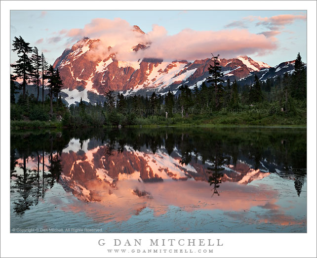
Sunset, Mt. Shuksan and Picture Lake

Sunset, Mt. Shuksan and Picture Lake

Sunset, Mt. Shuksan and Picture Lake. Mt. Baker-Snoqualmie National Forest, Washington. August 28, 2010. © Copyright G Dan Mitchell – all rights reserved.

Sunset on cloud-shrouded summit of Mt. Shuksan with Picture Lake in the foreground, Mt. Baker-Snoqualmie National Forest, Washington.

Icon alert! I understand that photographing Mt. Shuksan from this locale is, in the Pacific Northwest context, perhaps almost equivalent to photographing the Golden Gate Bridge from the Marin Headlands or photographing Yosemite Valley from Tunnel View. As a brand new photographer of Cascades Range subjects, I plead guilty to succumbing to this icon and photographing it. (I’m told that the only thing that this photograph needs in order to qualify for full “yet another photo of an icon” status would be to come back in a month and shoot it when the fall colors appear.)

My brother and I had been up higher photographing the Artist Point area for most of the afternoon, and he suggested that since we were here we might stop at Picture Lake on the way back down the mountain and see what might develop. I’m glad he did since, icon status aside, this really is a stunning and beautiful location and it was a quiet and beautiful evening. Several things made it special, I think. First, while the summit of Shuksan never fully cleared, the clouds shrouding the summit gave it a more dramatic aspect than might have been the case with an unobstructed view. Second, much to our surprise, we were not joined by a throng of other photographers. At first we were the only ones there, and later we only saw a few others in the area.

This was a technically challenging scene to photograph. The lake and foreground trees were in shadow at this point, though on the scene one could still see the details of the forest along and beyond the far shore. Yet the summit of Shuksan and the clouds were in full sun, and making this even more difficult, the red sunset light was extra intense. The eye can take all of this in without a problem as you move your focus from foreground to distant peak, but the camera is not as capable – and the dynamic range of the scene dramatically exceeds the capabilities of cameras. So, again, this photograph is a composite of three exposures manually blended in post to combine the best exposures of bright and saturated highlights with the best exposure of the dark forest along the shore of the lake.

Update on 9/29/10: I recently noticed that I had misidentified the lake in the photograph! I have corrected the post to call it by its correct name, Picture Lake.

This photograph is not in the public domain and may not be used on websites, blogs, or in other media without advance permission from G Dan Mitchell.

G Dan Mitchell Photography | Twitter | Friendfeed | Facebook | Facebook Fan Page | Email

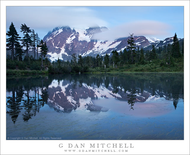
Dusk Clouds, Mount Shuksan

Dusk Clouds, Mount Shuksan

Dusk Clouds, Mount Shuksan. Mt. Baker-Snoqualmie National Forest, Washington. August 28, 2010. © Copyright G Dan Mitchell – all rights reserved.

Evening fog clouds shroud the summit of Mt. Shuksan above Picture Lake – Mt. Baker-Snoqualmie National Forest, Washington.

Since we were in the neighborhood – we passed right past it on our way down from Artist Point – my brother suggested that we stop and photograph the iconic view of Mt. Shuksan from Picture Lake. Actually, as I understand it, the really iconic image is usually made about a month later when the slope along the far shore of the lake turns golden with fall foliage. I only knew the location from photographs, so I was surprised to find that it is a roadside lake with a boardwalk/trail to the typical shooting location! I understand that if I were to return in a month I would be shoulder to shoulder with scores of photographers – but on this evening we were initially the only ones there, though a couple others photographers eventually showed up.

When we arrived things did not look too promising in photographic terms. The peak of Shuksan was entirely socked in by clouds and fog, but my brother said that, in his experience, it was not uncommon for the fog to dissipate and rise as the day ends. (This was in line with my knowledge that the best light can often happen after the sun sets – and I’m always surprised at the number of photographers who pack up and leave before this happens.) As we watched, the saturated colors of the last moments of the day came on and, as if on cue, the clouds began to thin. This was perhaps the very last photograph I made. It was shot some time after the actual sunset and the conditions were quite dark. I thought that a very long post-sunset exposure might capture the diffused quality of the clouds as they moved across the face of the peak and that it might be possible to capture some of the very subtle post-sunset coloration. In the end this exposure was a bit longer than two minutes.

This photograph is not in the public domain and may not be used on websites, blogs, or in other media without advance permission from G Dan Mitchell.

G Dan Mitchell Photography | Twitter | Friendfeed | Facebook | Facebook Fan Page | Email
Evening, Unnamed Lake and the Great Western Divide

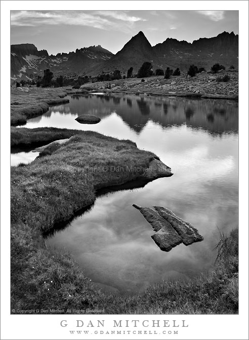
Evening, Unnamed Lake and the Great Western Divide

Evening, Unnamed Lake and the Great Western Divide. Sequoia National Park, California. August 2. 2010. © Copyright G Dan Mitchell – all rights reserved.

Evening sky over the Great Western Divide reflected in an unnamed alpine lake, Sequoia National Park, California.

I don’t know quite what to say about this area of the Sierra located just east of the Great Western Divide in the upper reaches of the Kern River drainage – I’ve been very close to here on many previous trips, but I never quite managed to hop the intervening ridge even though I’ve thought vaguely about visiting this area for decades and I once passed through the lower reaches of it, more or less by accident and completely unaware of what was just upstream.

A group of us traveled over Kearsarge Pass (11,700’+) and Forrester Pass (13, 200′) to arrive in the upper Kern at Tyndall Creek along the JMT. (I think the general area is also known as the “bighorn plateau.”) I’ve been here on several previous occasions while heading to or circumnavigating Mt. Whitney. While I’ve gone east (to exit over the very rough Shepherd Pass at 12,000′) I’ve not really explored west and north of this area. Our general plan on this trip was to rectify that, specifically by visiting remote and very high Lake South America. After wandering up a mosquito-infested valley, climbing its headwall, and then dropping to a lake just below the saddle we made it to Lake South America. We had originally planned to stay here overnight, but the very barren and rocky surroundings didn’t attract us in the end, so we decided to head on to the west and south.

After a bit of a walk on a somewhat rough trail (which got much rougher later on) we arrived at a series of timberline lakes overlooking the Great Western Divide, which towered above us to the west. There is much I could say about this area, but I’ll limit myself to a few comments… and not name the specific location we visited. We finally found a sandy camping spot between a few lakes and tarns – it was surrounded by stunning alpine views ranging from the lakes themselves and the surrounding rocky meadows and clumps of trees to the jagged and high peaks to our west. The next morning we followed a very faint trail down the canyon, passing almost continuously through astonishing scenery featuring intimate, granite-surrounded meadows and small lakes.

I must go back. It won’t be easy. I’ll want to carry a bit more photography gear than I carried on this trip, and I’ll want to stay a day or two longer. And the location is two to three days from the nearest trailheads, all of which take you over some very high passes.

This photograph is not in the public domain and may not be used on websites, blogs, or in other media without advance permission from G Dan Mitchell.

G Dan Mitchell Photography
About | Flickr | Twitter | Facebook | Google+ | 500px.com | LinkedIn | Email

Text, photographs, and other media are © Copyright G Dan Mitchell (or others when indicated) and are not in the public domain and may not be used on websites, blogs, or in other media without advance permission from G Dan Mitchell.

(Basic EXIF data is available by “mousing over” large images in blog posts. Leave a comment if you want to know more.)


Cascade, Tyndall Creek

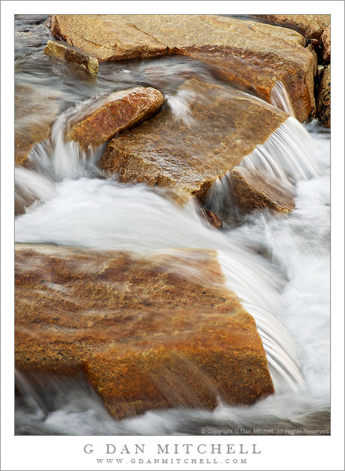
Cascade, Tyndall Creek

Cascade, Tyndall Creek. Sequoia National Park, California. August 1. 2010. © Copyright G Dan Mitchell – all rights reserved.

High in the Upper Kern River drainage, water dashes over the rocks of Tyndall Creek.

Tyndall Creek is in one of my most favorite areas of the Sierra Nevada. It runs between Shepherd Pass (located on the Sierra Crest a bit north of Mount Whitney) and the upper reaches of the Kern River in Sequoia National Park. It begins, more or less, in a small, barren lake right on the crest at the verge of the drop-off into Shepherd Pass, flows gently westward through alpine rock gardens as it descends towards timberline, and then drops more quickly to join the Kern a few miles later. It crosses the John Muir Trail where one encounters almost the first trees after descending from 13,200′ Forrester Pass to the north. Quite a few JMT travelers camp at this spot – partly because of the shelter of the trees and partly because of the terraced rocks over which the creek passes here.

G Dan Mitchell Photography
About | Flickr | Twitter | FacebookGoogle+ | 500px.com | LinkedIn | Email

Text, photographs, and other media are © Copyright G Dan Mitchell (or others when indicated) and are not in the public domain and may not be used on websites, blogs, or in other media without advance permission from G Dan Mitchell.

(Basic EXIF data is available by “mousing over” large images in blog posts. Leave a comment if you want to know more.)