Swift water flows over granite along the bank of the Tuolumne River, Yosemite National Park.
In this section of the Tuolumne River – as in many other places throughout the Sierra Nevada – the river passes through a steep section and across granite slabs that span the full width of the river. As the water flows over the granite it forms constantly changing patterns of rock and whitewater that can only be predicted in general ways. The spot included in the photograph was right along the edge of the river, and you can see the transition between the diminished flow along the bottom edge and the faster and more abundant water in the main channel beyond.
Part of the fun of shooting this sort of subject – and shooting it is a pleasant way to spend an hour along the river – is in trying to find workable compositions in such a changeable subject. And making it even more “fun,” the shutter speed becomes an important decision as it determines just much the image is affected by motion blur and how much of the scene is stopped. Fortunately, digital cameras make this process just a bit more predictable and productive, since they allow the photographer to quickly see the result of composition and shutter speed choices and verify whether or not the educated guesses were correct, and to see just how the infinitely variable and unpredictable patterns of flowing water come together at the instant of exposure.
G Dan Mitchell is a California photographer whose subjects include the Pacific coast, redwood forests, central California oak/grasslands, the Sierra Nevada, California deserts, urban landscapes, night photography, and more. Blog | About | Flickr | Twitter | Facebook | Google+ | 500px.com | LinkedIn | Email
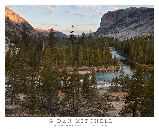
Early light on morning clouds above the Tuolumne River Canyon below Glen Aulin, Yosemite National Park.
This is the same bend in the Tuolumne River, located below Glen Aulin and before the river descends toward Waterwheel Falls and eventually the abomination of Hetch Hetchy Reservoir, that was shown in a photograph of late afternoon light that I posted here a few days ago. This time it was early morning. We had been up well before sunrise and had wandered off in various directions to find early morning photographic subjects. My main goals were the cascading water along the edge of this section of the river (a bit of which is visible in the lower portion of the frame) and a granite bowl to the right of this view. As I came over the rise above this area before descending I saw the beautiful sparse clods to the west, probably extending to the edge of the Sierra and still with pastel colors from dawn light.
A technical observation about this photograph. This scene presented a technical challenge in the form of an extremely wide dynamic range between the bright and red-saturated first direct sunlight on the ridge at upper left and the much darker areas of forest in shade along the river and in the foreground. With a digital exposure, in a scene like this one, the primary rule for me is “don’t blow out the highlights.” If I had overexposed the sky the clouds would have turned into pure white, texture-free blotches and that bit of early sun on the rocks would have lost detail and taken on a very strange coloration. However, an exposure that protects the highlights in a scene like this one can leave the shadows nearly black. While it is possible to “fix” that a bit in post, the result is not necessarily very good when the dynamic range is very large. One “traditional” solution would have been to use a graduated neutral density filter (or “GND”) that blocked some of the brightest areas at the top of the frame while not affecting the lower 2/3 or so. But I don’t use them, and in this case the result would not have been totally wonderful since the same filtering that would reduce sky brightness would also make the large granite dome at the right end up nearly black at the top.
So instead of filtering at the time of exposure, I decided that I would use the roughly comparable, but more flexible, “exposure blending” techniques in post. With that in mind I made several photographs at different exposures – some at shorter shutter speeds to avoid the blown out highlights and others at increasingly slower shutter speeds to reveal the shadow detail that my eyes could see but which the camera otherwise could not. During the post-production phase, I selected two of the exposures, one that was as bright as possible but without blowing out the sky and sunlight, and the other two stops lighter to reveal that shadow detail in a way that seemed consistent with what I recall the scene actually looked like. The two source images were carefully adjusted during raw conversion and their two layers carefully aligned. With the darker image (the one with the “good” sky) on the top, I began to “paint” out the mask to reveal the details of the foreground forest, river, and rocks. (In answer to the expected question, this is not the same as HDR. That is a more or less automated process that works in a different way. Exposure blending is typically a manual process that relies a great deal on the photographers judgment and recall of the actual scene.)
G Dan Mitchell is a California photographer whose subjects include the Pacific coast, redwood forests, central California oak/grasslands, the Sierra Nevada, California deserts, urban landscapes, night photography, and more. Blog | About | Flickr | Twitter | Facebook | Google+ | 500px.com | LinkedIn | Email
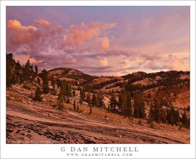
Evening clouds from dissipating afternoon thunderstorms in early evening light above the Tuolumne River Valley, Yosemite National Park.
I recently posted a photograph of wildly colorful sunset clouds made a bit earlier on this same evening this past September as I was concluding a week-long photography backpack into the Yosemite back-country. By the time I had the photograph shown here, the most psychedelic of the sunset colors had begun to fade (though the reddish coloration on the granite is from that light) and I turned my attention to the thinning clouds.
Not much earlier, these clouds had been part of a massive line-up of huge thunderstorms over Yosemite high-country. I had escaped the rains since I was now in the relative lowlands around Glen Aulin, but it was clear that these had been some powerful localized storms. But as typically happens on many Sierra evenings, the giant storms soon dissipated and the clouds thinned to transparency as the day came to an end. By the time I made this photograph only a bit of direct sunlight was striking the tops of the highest remaining clouds.
G Dan Mitchell is a California photographer whose subjects include the Pacific coast, redwood forests, central California oak/grasslands, the Sierra Nevada, California deserts, urban landscapes, night photography, and more. Blog | About | Flickr | Twitter | Facebook | Google+ | 500px.com | LinkedIn | Email
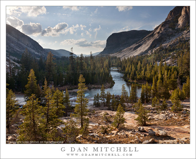
The Tuolumne River enters Tuolumne River Canyon below the Glen Aulin High Sierra Camp.
This photograph looks west from a rocky point along the Tuolumne River just below Glen Aulin in the Yosemite National Park back-country. In September I spent a total of four nights in this specific area and photographed in and around the granite bowl that rises from the river near the foreground rocks and spreads to the right of the area shown here. The photograph was made very late in the afternoon – it had been raining when I arrived at Glen Aulin but, as often happens in the Sierra, the clouds dissipated later in the day and the skies were starting to clear before sunset.
While my favorite Sierra landscape is at the elevations where the last small trees give way to alpine tundra meadows and the rocky slopes of the highest peaks, there is also something very compelling about these lower (from my point of view) elevation areas, and especially about this particular spot along the Tuolumne. Looking west from this point along the river I had the distinct feeling that I was standing more or less on a boundary between the higher and more alpine zones (exemplified by the Tuolumne Meadows area) and the beginnings of the lower areas in which I feel like I’m heading towards the Central Valley. Here, all of the really tall peaks are behind me (OK, some are to my right…) and before me the land overall drops towards the Valley, the slightly hazy light and air of which is in the far distance in this photograph.
Making this feeling even stronger for me is the fact that very close to Glen Aulin, the Tuolumne abruptly changes from a generally meandering river that descends very gradually for the most part past large meadows and forests to one that drops precipitously into an increasingly narrow and steep canyon surrounded by granite slabs and domes and peaks that begin to take on an appearance that reminds me of Yosemite Valley.
G Dan Mitchell is a California photographer whose subjects include the Pacific coast, redwood forests, central California oak/grasslands, the Sierra Nevada, California deserts, urban landscapes, night photography, and more. Blog | About | Flickr | Twitter | Facebook | Google+ | 500px.com | LinkedIn | Email
Photographer and visual opportunist. Daily photos since 2005, plus articles, reviews, news, and ideas.
Manage Consent
To provide the best experiences, we use technologies like cookies to store and/or access device information. Consenting to these technologies will allow us to process data such as browsing behavior or unique IDs on this site. Not consenting or withdrawing consent, may adversely affect certain features and functions.
Functional
Always active
The technical storage or access is strictly necessary for the legitimate purpose of enabling the use of a specific service explicitly requested by the subscriber or user, or for the sole purpose of carrying out the transmission of a communication over an electronic communications network.
Preferences
The technical storage or access is necessary for the legitimate purpose of storing preferences that are not requested by the subscriber or user.
Statistics
The technical storage or access that is used exclusively for statistical purposes.The technical storage or access that is used exclusively for anonymous statistical purposes. Without a subpoena, voluntary compliance on the part of your Internet Service Provider, or additional records from a third party, information stored or retrieved for this purpose alone cannot usually be used to identify you.
Marketing
The technical storage or access is required to create user profiles to send advertising, or to track the user on a website or across several websites for similar marketing purposes.