Winter clouds fill the evening sky above the eastern slopes of the Panamint Range in Death Valley National Park.
After the long drive from the San Francisco Bay Area I arrived at Stovepipe Wells in Death Valley and set up my camp in the mid afternoon and hung out a bit, thinking about the prospects of late afternoon and evening shooting. Because a weather front was coming in (the forecast called for a chance of rain in the Valley and pretty much certain light snow over the passes) the clouds were increasing, in many directions heading past the point of “picturesque” and more towards “socked in.” I was hoping for some evening light – or early rain? – but it seemed less promising as evening approached. In circumstances like these I may come up with a few possible shooting alternatives ahead of time, watch as conditions develop, and make a last-minute decision about where to go based on observations and hunches.
So, late in the afternoon I stopped near Death Valley Dunes and worked to line up some long shots that filled the background of the dunes with the rugged shapes of the Grapevine Mountains, and then headed towards the junction with the road to Scotty’s Castle to try to figure out if the light held more promise to the north or the south. It didn’t look totally promising in either direction, but I thought that I might be able to make something out of the haze to the south as the ridges on both sides of the Valley receded, especially if a bit of glow in the sky turned up right at sunset. So, south it was.
I drove just a little ways in that direction to a point where the road curves a bit towards the east to travel around the northernmost area of salt flats in what I think of as the lower valley – this is the area a bit south of the Salt Creek cutoff. From here there is a fairly open view all the way down to the end of the Valley, and it looked like the clouds were going to evolve in some interesting ways. It didn’t look like I would see a gaudy, brilliantly colorful sunset, but something more subtle and quiet looked like it might happen. As the light began to fade I made a series of photographs whose subject was largely the sky and the atmospheric recession along the Panamint Range (shown here) on the west side of the Valley and the mountains just beyond Furnace Creek.
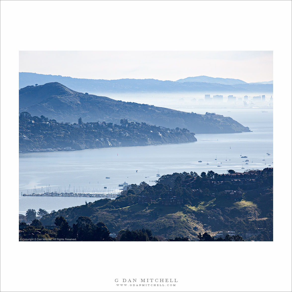
“Richardson Bay, Morning” — Photograph of Richardson Bay from Marin hills, showing Tiburon Peninsula, Angel Island, downtown Oakland, East Bay Hills, and Mount Diablo in the distance.
This photograph was shot from essentially the same position as the previous one, a black and white photo of the same vista, though with shorter focal length. I used a longer focal length here to try to enlarge to closer elements and leave out some of the stuff along the edges, and to minimize the amount of sky to some extent. I liked the color version of this – it was hard for me to think about giving up the nice overall blue haze, but even more to give up the was of light on some of the green grassy areas at the bottom of the frame.
There is quite a bit of stuff in this image, so let me describe what you see. At the bottom of the frame are hills above Marin City. Beyond the foreground hills you see Richardson Bay, which is an arm of San Francisco Bay near the entrance to Golden Gate. Across the bay we see the hills of the Tiburon Peninsula and beyond that looms the peak of Angel Island. In the distance and across San Francisco the buildings of downtown Oakland are visible through the low level backlit morning haze. Beyond are the East Bay Hills and the furthest peak is Mount Diablo, all the way out past Concord.
The north tower of the Golden Gate Bridge, with San Francisco Bay, the San Francisco Oakland Bay Bridge, a departing ship, and the East Bay hills beyond in morning fog and haze.
I’ve been working on the color version of this photograph, which proved to be a bit more tricky than I would have expected. My recollection of the light on this morning was that it was very bright – with the backlit haze/fog – and quite blue. But, as often happens, the coloration in the camera was dissonant with my memory, and I had to think a bit about where I wanted to go with the photography in post. In particular, the sky had an odd pink cast that can often become more obvious when using a long lens and only keeping a bit of the sky right above the horizon.
The background on this photograph (and several others in the same series) is that it was made on an early February morning shortly after sunrise from a point high in the Marin Headlands of the Golden Gate National Recreation Area. For the most part it was actually a brilliantly sunny and clear morning, but an inversion layer was creating a thin blanket of fog/haze that was almost too bright to look at and which muted the details of the landscape. (It was also tremendously windy – making it a challenge to shoot with a long lens!) After making a few initial exposures from a more obvious location – and one that was slightly out of the wind – I decided to wander a bit and look for juxtapositions of various landscape elements with the shape of the north tower of the bridge. After a short walk I found this spot where the tower was centered between the two towers of the more distant western span of the San Francisco Oakland Bay Bridge, and where the view included a bit of the San Francisco waterfront along the right margin and the fog-covered flatlands below the East Bay hills.
As I worked I noticed a freighter leaving the Port of Oakland beyond the further bridge. I’ve watched enough of these ships heading across the bay that I have a pretty good idea of the path they follow, and I knew that this one would cross beneath the Bay Bridge and then turn to cross the frame towards the left – so I waited for it to reach the position just barely to the left of the closer bridge tower before making this exposure.
UPDATE: As of 2020 I am no longer posting annual updates concerning this subject — and I am editing older posts on the subject in light of the need to be more responsible about not encouraging the onslaught. I also no longer recommend going to the Valley to see it. Unfortunately, too much exposure (yes, I played a part in it, unfortunately) has led to absurd crowds, traffic jams, littering, destruction of areas in the Valley where too many people go to see it… and the park has increasingly — and appropriately — cracked down. Parking options have been eliminated, at least one viewing location has been closed. Good news! The rest of Yosemite Valley is still there and often exceptionally beautiful at this time of year.
As more and more people now seem to know, late February is the prime time for the appearance of the “natural fire fall” in Yosemite Valley, when the setting sun may strike Horsetail Fall near the east end of the face of El Capitan, and when viewed from the right angle create a striking light show. I do not plan to be there to photograph the event this year since I’ll likely be shooting somewhere else during the prime time for the fall… and I no longer encourage others to attempt it. I’ll explain below.
The spectacle of Horsetail Fall is now quite well known. The initial renown came after Galen Rowell produced a striking and now-famous photograph of it several decades ago. Eventually others began to photograph it as well. (I read somewhere that several other well-known photographers made images of Horsetail decades earlier, but apparently no one “discovered” the special annual sunset light until Rowell shot it.) Since that time, and especially in the past few years, news of the phenomenon and information about when, where, and how to shoot it has become widespread – especially now that information travels so fast on the Internet. As of this article revision, a plethora of articles (newspapers, magazines, the web) and social media posts have built the thing up beyond all reason, with predictable and unfortunate results.
Twice each year, the setting sun lines up just right so that it casts its final light directly on this waterfall for a few weeks. The phenomenon is ephemeral and dependent on a series of conditions that must all occur at the right time. First, it must be during that short window of time when the setting sun strikes the location of the fall on a high cliff. Second, the waterfall must be flowing. Typically this means that there has been a good amount of snow followed by a warm-up that melts enough of it to get the fall going, though a warm winter rain could accomplish the same thing. Third, the western horizon must be clear so that the sun’s light will not be obstructed as it sets. (Those who have tried to shoot the fall a few times may have experienced disappointment when a crescendo of light potential occurs late in the day… only to be suddenly switched off as the sun drops behind low clouds to the west. To be honest, this happens more often than not.)
The photographer wants where light hits the fall more or less from behind. The number of suitable locations is quite limited and — no surprise — they end up being hugely crowded.
Having said all of this, be aware that it is going to be extremely difficult to get a photograph of Horsetail that hasn’t already been done. I’ve seen a few, but most essentially duplicate existing images. In some ways, I think that contemplating the fact that such a thing actually happens in a place that already contains as many marvels as we see in the Valley may be more rewarding than making another photograph of it.
A downside to the experience is that the popularity of “bagging this shot” has taken off remarkably in the past few years. Yosemite Valley is obviously already a place where it is tempting to run from well known spot to well known spot trying to recreate the well known photographic images that others have produced there. (Ironically, those who take this approach often miss many, many less known subjects in the Valley that can be every bit as beautiful and rewarding.) With Horsetail, the rush of photographers is compressed into a very short time period and focused on a few (mostly only two!) very popular shooting locations. Those who shoot from them on prime evenings may arrive in the morning to reserve a spot… to find a crowd of photographers is already set up.
As of the date of this revision in 2020 the situation has become quite insane, and the park service has had to take serious steps to control the mess. Literally thousands of photographers and others have been arriving in places that used to handle a dozen or two folks. Traffic jams ensued, the experience has been significantly degraded, parking is a mess, and the crowds are damaging park features. As of this year large sections of park roads are now off-limits to parking and one of the two popular locations has been completely closed.
I strongly urge you to NOT go.
I was fortunate a few years ago to have a nearly solitary experience photographing the fall. That winter Northside Drive was closed and all traffic was routed in and out of the Valley along Southside Drive. It had snowed, and one of the locations for photographing the fall was only accessible by hiking across the Valley in snow to Northside Drive and then walking a bit further in the snow to the place from which I shot. I walked over early and spent an hour or more shooting alone in the silent and snow-covered El Capitan meadow! Then, as sunset approached, I walked quietly to a place where I could see the fall and joined a small handful of fellow photographers waiting for the event. We weren’t disappointed.
That is the way I want to remember photographing Horsetail Fall.
(Some of my Horsetail photographs are found here.)
Photographer and visual opportunist. Daily photos since 2005, plus articles, reviews, news, and ideas.
Manage Consent
To provide the best experiences, we use technologies like cookies to store and/or access device information. Consenting to these technologies will allow us to process data such as browsing behavior or unique IDs on this site. Not consenting or withdrawing consent, may adversely affect certain features and functions.
Functional
Always active
The technical storage or access is strictly necessary for the legitimate purpose of enabling the use of a specific service explicitly requested by the subscriber or user, or for the sole purpose of carrying out the transmission of a communication over an electronic communications network.
Preferences
The technical storage or access is necessary for the legitimate purpose of storing preferences that are not requested by the subscriber or user.
Statistics
The technical storage or access that is used exclusively for statistical purposes.The technical storage or access that is used exclusively for anonymous statistical purposes. Without a subpoena, voluntary compliance on the part of your Internet Service Provider, or additional records from a third party, information stored or retrieved for this purpose alone cannot usually be used to identify you.
Marketing
The technical storage or access is required to create user profiles to send advertising, or to track the user on a website or across several websites for similar marketing purposes.