
Tag Archives: alpine

Alpine Tarn, Great Western Divide

Alpine Tarn, Great Western Divide

Alpine Tarn, Great Western Divide. Sequoia National Park, California. August 2, 2010. © Copyright 2010 G Dan Mitchell – all rights reserved.

The peaks of the Great Western Divide tower above a small alpine tarn reflecting afternoon light, Sequoia National Park.

Our original goal on this late-July, early-August southern Sierra backpacking trip was to be Lake South America, a very high, very barren, and very remote lake in the upper reaches of the Kern River basin in Sequoia National Park. Believe it or not, I’ve thought of visiting this lake for decades, ever since a very early pack trip on which I planned to go there but ended up bypassing the lake and exiting in Mineral King. (Mineral King is nowhere near Lake South America. It is a long story… :-)

After staying on the JMT at Tyndall Creek the night before, we headed up over the ridge to the northwest in the morning. After walking up a broad and mosquito infested marshy valley, we climbed the steep headwall at the upper end of this valley and looked down at a lake on the other side. Just beyond this lake was Lake South America. Oddly, when we arrived we were not tremendously excited by the scene. Yes, it is a wild and high place in the heart of the Sierra, but for some reason it seemed a bit like many other high, barren lakes we had visited before… and we decided to make only a very brief visit and then move on.

This turned out to be a great decision. After returning to the lake that we had passed just prior to the short side trip to Lake South America, we picked up a trail heading towards the head waters of the Kern and eventually dropped down to a set of about four beautiful lakes just below treeline. The lakes, unnamed as far as I can tell, seem to sit at the edge of a valley with the high and jagged peaks of the Great Western Divide just beyond, providing one of the most rugged and spectacular scenes I’ve encountered in the Sierra. Needless to say, we decided to camp here despite the mosquito hatch that was currently underway.

This photograph is not in the public domain and may not be used on websites, blogs, or in other media without advance permission from G Dan Mitchell.

G Dan Mitchell Photography
About | Flickr | Twitter | Facebook | Google+ | 500px.com | LinkedIn | Email

Text, photographs, and other media are © Copyright G Dan Mitchell (or others when indicated) and are not in the public domain and may not be used on websites, blogs, or in other media without advance permission from G Dan Mitchell.

(Basic EXIF data is available by “mousing over” large images in blog posts. Leave a comment if you want to know more.)
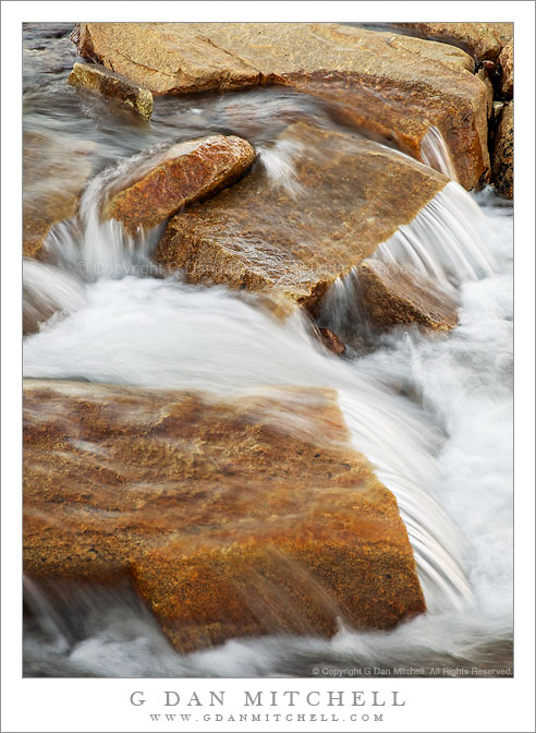
Cascade, Tyndall Creek

Cascade, Tyndall Creek

Cascade, Tyndall Creek. Sequoia National Park, California. August 1. 2010. © Copyright G Dan Mitchell – all rights reserved.

High in the Upper Kern River drainage, water dashes over the rocks of Tyndall Creek.

Tyndall Creek is in one of my most favorite areas of the Sierra Nevada. It runs between Shepherd Pass (located on the Sierra Crest a bit north of Mount Whitney) and the upper reaches of the Kern River in Sequoia National Park. It begins, more or less, in a small, barren lake right on the crest at the verge of the drop-off into Shepherd Pass, flows gently westward through alpine rock gardens as it descends towards timberline, and then drops more quickly to join the Kern a few miles later. It crosses the John Muir Trail where one encounters almost the first trees after descending from 13,200′ Forrester Pass to the north. Quite a few JMT travelers camp at this spot – partly because of the shelter of the trees and partly because of the terraced rocks over which the creek passes here.

G Dan Mitchell Photography
About | Flickr | Twitter | FacebookGoogle+ | 500px.com | LinkedIn | Email

Text, photographs, and other media are © Copyright G Dan Mitchell (or others when indicated) and are not in the public domain and may not be used on websites, blogs, or in other media without advance permission from G Dan Mitchell.

(Basic EXIF data is available by “mousing over” large images in blog posts. Leave a comment if you want to know more.)

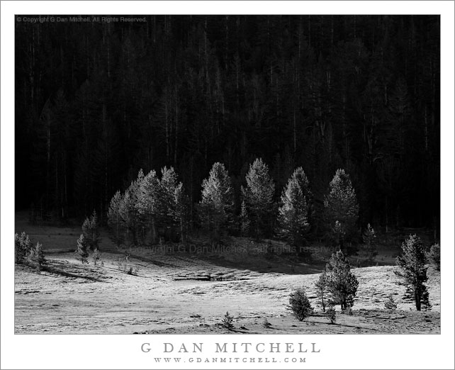
First Light, Tioga Meadows

First Light, Tioga Meadows

First Light, Tioga Meadows. Yosemite National Park, California. July 24, 2010. © Copyright G Dan Mitchell – all rights reserved.

The first morning light touches trees at the edge of Tioga Meadows, Yosemite National Park.

I always enjoy photographing the light at the edges of shadows as they move across the landscape early and late in the day, and I especially like the way that this light can gradually pick out subjects like these trees against a still-unlit background. With this in mind I was near Tioga Pass early in the morning as the light began to work its way down into Tioga Meadow as the sun rose above the ridges of Mounts Dana and Gibbs.

A bit of an ironic note: I was so focused on the light and the trees that I failed to notice that two deer were grazing in the scene until I began working on the photograph after returning home! If you look very closely you may be able to find one that is right at the shadow/sun edge, but I’d be surprised if anyone can find the second one.

This photograph is not in the public domain and may not be used on websites, blogs, or in other media without advance permission from G Dan Mitchell.

G Dan Mitchell Photography | Twitter | Friendfeed | Facebook | Facebook Fan Page | Email

keywords: first, light, morning, tioga, meadows, pass, forest, mount, dana, lodgepole, tamarack, pine, deer, yosemite, national, park, california, usa, north america, sierra, nevada, mountain, range, alpine, black and white, monochrome, nature, landscape, scenic, travel, stock, shadow, hill, grove

Thawing Ice, Sierra Nevada

Thawing Ice, Sierra Nevada

Thawing Ice, Sierra Nevada. Yosemite National Park, California. June 29, 2010. © Copyright G Dan Mitchell – all rights reserved.

Ice melts on the frozen surface of an alpine lake near the crest of the Sierra Nevada mountains, Yosemite National Park.

When I visited this lake very close to the Sierra Crest in the Yosemite back-country in late June, it was still completely covered with winter ice – though the thaw was well underway and the surface was a complex pattern of frozen sections and pools of water on top of the ice that reflected the sky, clouds, and surrounding mountains.

This photograph is a stitched panorama, created by combining two landscape mode photographs in the post-processing phase.

This photograph is not in the public domain and may not be used on websites, blogs, or in other media without advance permission from G Dan Mitchell.

G Dan Mitchell Photography | Twitter | Friendfeed | Facebook | Facebook Fan Page | Email

Technical Data:
Canon EOS 5D Mark II
Canon EF 70-200mm f/4 L USM at 200mm
ISO 100, f/11, 1/640 second, stitched from two photographs

keywords: panorama, pattern, texture, reflection, gaylor, lake, basic, sky, cloud, shadow, frozen, water, alpine, sierra, nevada, mountain, range, crest, yosemite, national, park, tioga, pass, road, nature, landscape, scenic, travel, high, melt, thaw, ice, california, usa, north america, stock