Tag Archives: coastal

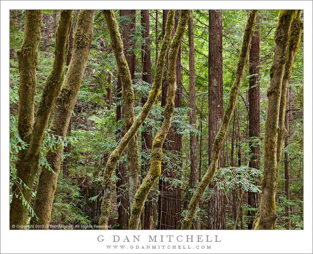
Redwoods and Big Leaf Maples, Gazos Creek

Redwoods and Big Leaf Maples, Gazos Creek - Redwood and big leaf maple forest along Gazos Creek, California
Redwood and big leaf maple forest along Gazos Creek, California

Redwoods and Big Leaf Maples, Gazos Creek. Northern California. July 12, 2011. © Copyright 2011 G Dan Mitchell – all rights reserved.

Redwood and big leaf maple forest along Gazos Creek, California.

I recall that on this day I had gone out to photograph along the Pacific coastline between Santa Cruz and San Francisco, California, mostly without any specific plan. First I had gone to one of my favorite Highway 1 bluffs to photograph the birds that pass within a few feet of it as they coast along the coastal updrafts. Then I moved north along the coast and discovered a group of kite surfers at one of the beaches, so I stopped and photographed them for a while.

Continuing north I came to a turn off to one of the many small roads that head up into the mountains that lie between the shoreline and the urban areas around San Francisco Bay. I took it and found myself driving along this narrow and twisty road that followed the bottom of a valley holding a small creek. The bottom of the steep and narrow canyon was deeply shaded by thick forest, including some stands of second-growth redwoods. This photograph was made in a nameless section of the valley where there was a spot to pull over and photograph the soft light filtering down through the moss-covered trees.

G Dan Mitchell is a California photographer whose subjects include the Pacific coast, redwood forests, central California oak/grasslands, the Sierra Nevada, California deserts, urban landscapes, night photography, and more.
Blog | About | Flickr | Twitter | FacebookGoogle+ | 500px.com | LinkedIn | Email

Text, photographs, and other media are © Copyright G Dan Mitchell (or others when indicated) and are not in the public domain and may not be used on websites, blogs, or in other media without advance permission from G Dan Mitchell.

Fog, Surf, and Rocks

Fog, Surf, and Rocks - Midday sun glows through coastal fog bank above offshore rocks and surf, Point Lobos State Reserve.
Midday sun glows through coastal fog bank above offshore rocks and surf, Point Lobos State Reserve.

Fog, Surf, and Rocks. Point Lobos State Reserve, California. March 29, 2012. © Copyright 2012 G Dan Mitchell – all rights reserved.

Midday sun glows through coastal fog bank above offshore rocks and surf, Point Lobos State Reserve.

I made a new photograph in the “barely there” series today at Point Lobos. It was a surprisingly good photography day at Point Lobos. I say this because when I started out this morning things did not look very promising at all. At my home, it was cloudy and gray – but since at least one weather forecast mentioned sun down in the Monterey Peninsula area, I decided to give it a try. As I drove south it got worse – I ended up in very thick fog during the first 30 minutes or so of my drive. However, recalling that when there is inland fog this time of year there is often clearing at the coast, I decided to keep going. A few miles from Monterey the skies began to clear, leaving some pockets of fog here and there with high thin clouds above. Now things were looking up! High, thin clouds can provide excellent conditions for many kinds of landscape shooting, since these conditions soften that shadows and take the harsh edge off of the light.

Arriving at Point Lobos I could see there was fog a good distance off shore, but beautiful light was shining through the forest along the entrance road. I headed down to Whalers Cove and went for a hike around the far side of the cove, and ended up spending the better part of three hours poking around in this area. By the time I got back to my car it was lunch time, and I decided to at least head out to the west-facing shoreline to look around before leaving. When I got there, the offshore fog bank had moved in and was starting to flow across the shoreline. A bit further south I could see the backlit fog lit brilliantly by the sun and almost obscuring the rocks and islands in the Bird Island area. In fact, by the time I got my camera on the tripod, these islands had completely disappeared. I waited a bit, and their shapes began to again barely emerge from the fog.

G Dan Mitchell is a California photographer whose subjects include the Pacific coast, redwood forests, central California oak/grasslands, the Sierra Nevada, California deserts, urban landscapes, night photography, and more.
Blog | About | Flickr | Twitter | FacebookGoogle+ | 500px.com | LinkedIn | Email

Text, photographs, and other media are © Copyright G Dan Mitchell (or others when indicated) and are not in the public domain and may not be used on websites, blogs, or in other media without advance permission from G Dan Mitchell.

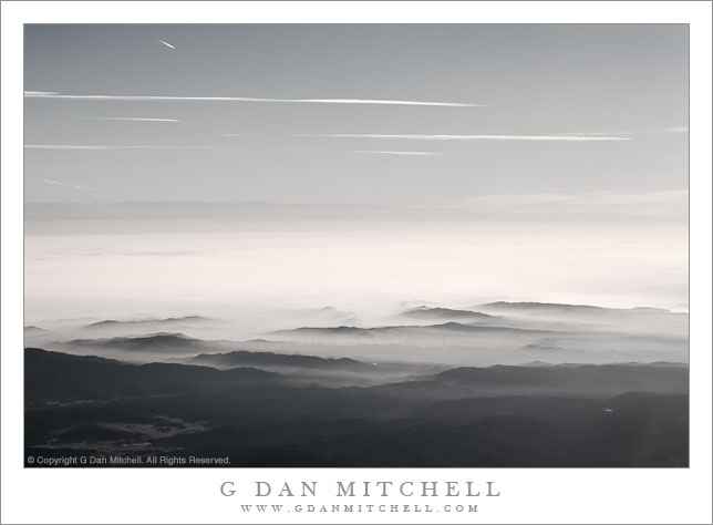
California Sky, New Years Morning

California Sky, New Years Morning

California Sky, New Years Morning. Over the San Francisco Bay Area, California. January 1, 2008. © Copyright 2008 G Dan Mitchell – all rights reserved.

The sky over Northern California, stretching from coastal hills and fog across the tule-fog-filled Central Valley to the Sierra Nevada, New Years Morning.

On New Years Day 2008 I flew to Seattle for a family visit. As we flew out of San Jose and over the hills along the eastern edge of the Bay Area, the winter tule fog was filling the Central Valley and spilling up against the hills, while above and beyond it was a nearly perfectly clear sky. For those who might be unfamiliar with the landscape here, beyond the fog-filled Central Valley, and very far away, the faint dark line of the Sierra Nevada crest is visible, and if you look very closely you may be able to see that the highest peaks are snow-capped.

This photograph has sat in the archive for over three years. I liked the scene but I wasn’t quite sure of what to do with the somewhat odd colors that resulted from shooting though an airplane window and into very bright light. I had considered a straightforward black and white interpretation and, if fact, that is what I was working on when I decided to instead desaturate the image about three-quarters of the way to being monochrome – and for me this seemed like just the right thing and more in line with how I think of the scene now. Another question was whether to clone out the contrail of another plane near the upper left corner. In the end I decided to leave it, for several reasons that I’ll leave to your imagination for now.

G Dan Mitchell Photography
About | Flickr | Twitter | FacebookGoogle+ | 500px.com | LinkedIn | Email

Text, photographs, and other media are © Copyright G Dan Mitchell (or others when indicated) and are not in the public domain and may not be used on websites, blogs, or in other media without advance permission from G Dan Mitchell.
(Basic EXIF data may be available by “mousing over” large images in posts when this page is viewed on the web. Leave a comment if you want to know more.)

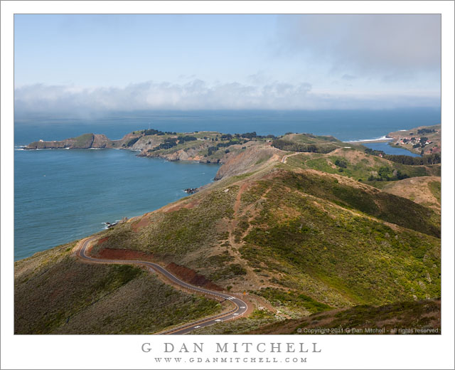
Offshore Fog Bank, Marin Headlands

Offshore Fog Bank, Marin Headlands

Offshore Fog Bank, Marin Headlands. Golden Gate National Recreation Area, California. July 14, 2011. © Copyright 2011 G Dan Mitchell – all rights reserved.

Offshore fog lies beyond Point Bonita and Rodeo Beach and the Marin Headlands of the Golden Gate National Recreation Area.

I was surprised to find a clear view like this during my mid-July visit to the Marin Headlands of the Golden Gate National Recreation Area (GGNRA) across the Bay from San Francisco. I had almost decided to stay home or go elsewhere based on weather reports that had the coast completely socked in my dense fog for most of the day. Indeed, it was foggy as I passed through San Francisco and drove across the Golden Gate Bridge. The fog was high, and I could see some distance beneath it, but it was still a rather gray day.

Since the lower section of Conzelman Road, the normal quick and scenic route up into the headlands, was closed for construction, I took that alternate route that passes through a tunnel to come out near Rodeo Beach. I turned left up the hill to reach the upper section of the road. After photographing near Battery 129 for a while, the sun began to break through the fog, and I was surprised to find a fairly clear patch just outside the Golden Gate.

The photograph shows the last section of the headlands as the hills drop towards the historic fort and batteries near the Point Bonito light house, which is barely visible at the end of the peninsula on the left. The line of surf at the upper right is Rodeo Beach, a popular spot with Bay Area folks.

G Dan Mitchell Photography
About | Flickr | Twitter | FacebookGoogle+ | 500px.com | LinkedIn | Email

Text, photographs, and other media are © Copyright G Dan Mitchell (or others when indicated) and are not in the public domain and may not be used on websites, blogs, or in other media without advance permission from G Dan Mitchell.
(Basic EXIF data may be available by “mousing over” large images in posts. Leave a comment if you want to know more.)