Tag Archives: distant

Manly Lake, Mountains and Clouds

Manly Lake, Mountains and Clouds
“Manly Lake, Mountains and Clouds” — Distant desert mountains and clouds reflected in the surface of Manly Lake, Death Valley.

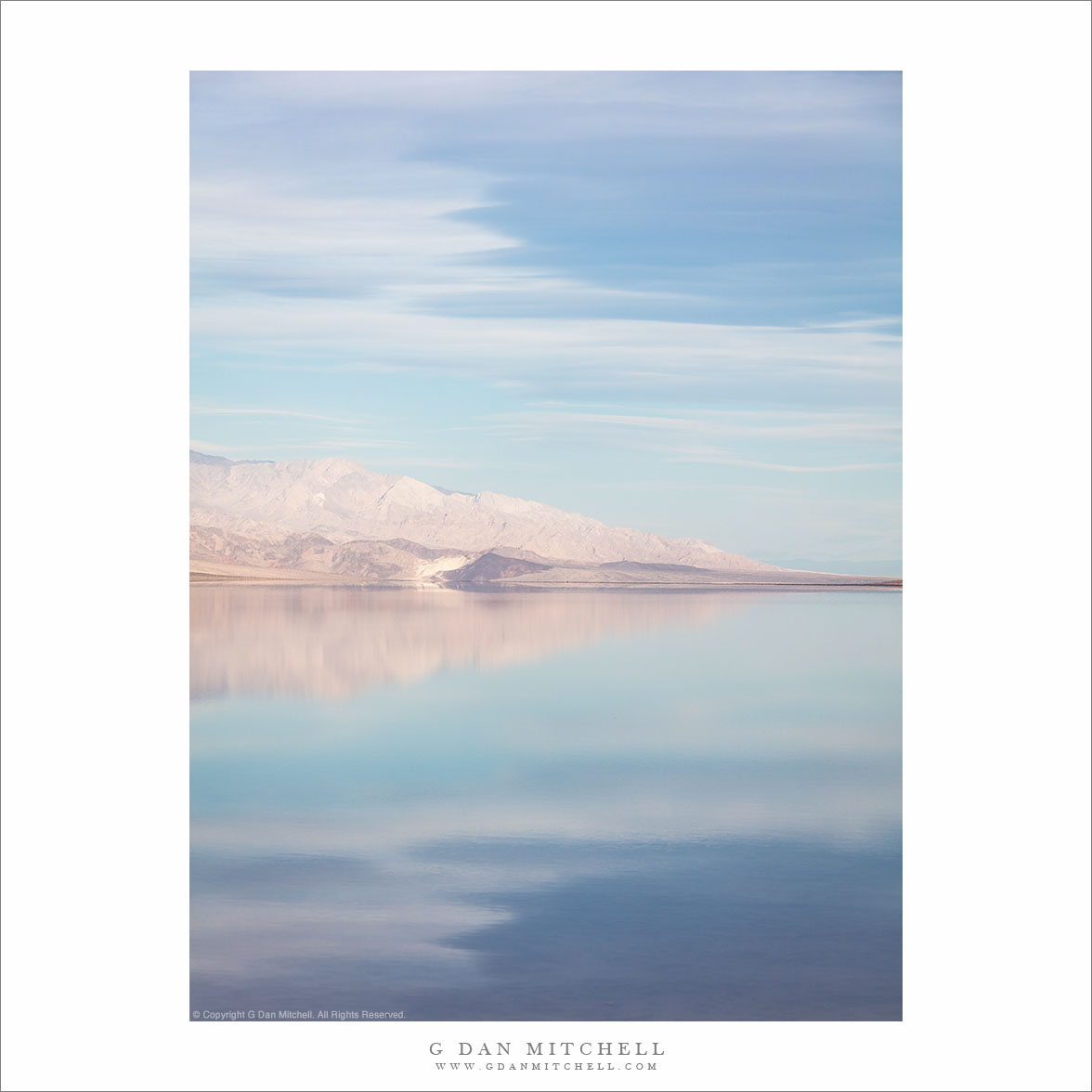
Lake Manly, the ancient body of water that occasionally reestablishes itself on the floor of Death Valley in wet years, has many moods. Before sunrise or at sunset, if there are clouds, it can reflect intensely colorful light from the sky.. As sunlight strikes the peaks of the Panamint Range, their golden light colors the water. Later in the day, especially if it is hazy, the scene can become soft and pastel.

On this winter solstice morning we began photographing before sunrise and continued through all of the light phases. I made this photograph after the warm sunrise light had dissipated, and when haze made blue the predominant color. The symmetry of the reflections abstracts the shapes of mountains and clouds.


Leave a comment or question using the form. (Click the title to see the full article and to comment if you are viewing it on the home page.)

G Dan Mitchell is a California photographer and visual opportunist. His book, “California’s Fall Color: A Photographer’s Guide to Autumn in the Sierra” (Heyday Books) is available directly from him. Blog | Bluesky | Mastodon | Substack Notes | Flickr | Email

All media © Copyright G Dan Mitchell and others.

Tufa, Island, Distant Mountains

Tufa, Island, Distant Mountains
“Tufa, Island, Distant Mountains” — Shoreline tufa formations, an island, and distant mountains, Mono Lake.

This view looks roughly north across the expanse of Mono Lake and Mono Basin. The foreground formations are tufa towers, exposed as the lake’s level dropped decades ago when Los Angeles began taking the water from feeder streams. The main body of the lake lies beyond the tufa. What appears to be the far shoreline is actually Paoha Island, a volcanic feature. In the far distance are desert mountains of the basin and range country.

I knew some history about the fights over Mono Lake’s water, but I learned something new on this visit. A few decades ago Los Angeles Water and Power bought out water rights up and down the Eastern Sierra, drastically changing the environment — and in places turning former lakes into dusty wastelands. This taking dropped the level of Mono Lake by many feet (it was too late for Tule Lake in Owen’s Valley) until court orders and regulations forced an agreement that LA would begin to protect the watershed, with a goal of eventually restoring the lake to a level closer to its historic level. I thought that serious progress had been made… but decades later the lake’s level is still dangerously low.

G Dan Mitchell is a California photographer and visual opportunist. His book, “California’s Fall Color: A Photographer’s Guide to Autumn in the Sierra” (Heyday Books) is available directly from him. Blog | Bluesky | Mastodon | Substack Notes | Flickr | Email

Join the discussion — you are welcome to leave a comment or question. (Comments are moderated and may not appear immediately.)

This site uses Akismet to reduce spam. Learn how your comment data is processed.

(All media © Copyright G Dan Mitchell and others.)

Tufa Tower, Lake, Blue Mountains

Tufa Tower, Lake, Blue Mountains
“Tufa Tower, Lake, Blue Mountains” — Mono Lake, a solitary tufa tower, and distant blue mountains in morning haze.

It is always a pleasure to visit the Mono Basin and its namesake lake, especially in the early morning when it is often still and quiet. I was there last week, dropping down one morning from a camp high up near the Sierra Crest. When I arrived I saw only one other car, and ts occupant was nowhere to be seen — it was as if I had the entire basin to myself!

I arrived well before sunrise and continued photographing right into the blue light of early morning. It was calm and the water reflected the blue of sky and distant mountains. I used a long lens to focus on a small section of those mountains, aligning them with a single tufa tower far out in the water.

G Dan Mitchell is a California photographer and visual opportunist. His book, “California’s Fall Color: A Photographer’s Guide to Autumn in the Sierra” (Heyday Books) is available directly from him. Blog | Bluesky | Mastodon | Substack Notes | Flickr | Email

Join the discussion — you are welcome to leave a comment or question. (Comments are moderated and may not appear immediately.)

This site uses Akismet to reduce spam. Learn how your comment data is processed.

(All media © Copyright G Dan Mitchell and others.)

Zabriskie to Rogers Peak

Zabriskie to Rogers Peak
“Zabriskie to Rogers Peak” — Long morning view, from formations at Zabriskie Point to distant Rogers Peak in the Panamint Mountains.

Poor Rogers Peak doesn’t get a lot of respect. Despite being just under 10,000 feet tall, offering a rather impressive view from close up, and being snow-capped in the winter… it is eclipsed by its neighbor, Telescope Peak, the highest in the park. (You can see a bit of the shoulder of Telescope Peak at the far left.) It doesn’t help that a communications complex has been installed on its summit — which seems like a bit of an inappropriate insult in a national park!

The photograph encompasses a very long view, extending from rugged hills at Zabriskie Point all the way across Death Valley to the summit of the Panamint Mountains. I estimate that this is over 20 miles as the proverbial crow flies. Such distances are common in Death Valley National Park, a huge place with an expansive landscape.


G Dan Mitchell is a California photographer and visual opportunist. His book, “California’s Fall Color: A Photographer’s Guide to Autumn in the Sierra” (Heyday Books) is available directly from him. Blog | Bluesky | Mastodon | Substack Notes | Flickr | Email

Join the discussion — you are welcome to leave a comment or question. (Comments are moderated and may not appear immediately.)

This site uses Akismet to reduce spam. Learn how your comment data is processed.

(All media © Copyright G Dan Mitchell and others.)