Tag Archives: dry

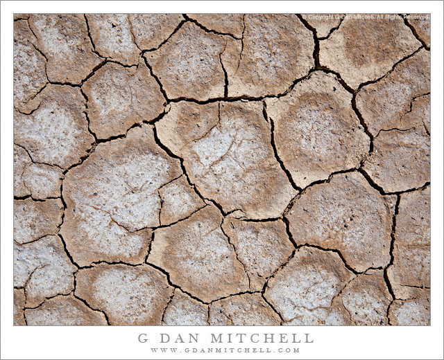
Playa Surface, Panamint Valley

Playa Surface, Panamint Valley

Playa Surface, Panamint Valley. Death Valley National Park, California. March 31, 2011. © Copyright G Dan Mitchell – all rights reserved.

Cracked and dry surface of the playa in Panament Valley, Death Valley National Park.

This micro-scene could be found in many locations in Death Valley and, for that matter, in many places in the USA and around the rest of the planet. But my little rectangle of the patterns of drying and cracked mud comes from the surface of the Playa (sometimes called “Panamint Lake?”) in upper Panamint Valley in Death Valley National Park. I wrote previously that it was the last day of my late-March photographic visit to Death Valley – I had finished my photography in the main Valley and had started the long drive back to the Bay Area. After crossing Towne Pass the road descends into Panamint Valley to a junction where I most often go south towards Trona and Ridgecrest and beyond.

Just before this junction the road crosses the playa, an extraordinarily flat surface formed when silt washed down from the surrounding mountains occasionally pools and gradually dries, forming what may be the flattest surfaces on the planet. As the moisture evaporates the mud cracks and splits into these interesting semi-geometrical patterns.

For no particular reason other than that this is a spot where I often make one final stop before leaving the park, I pulled over and wandered out onto the playa. I enjoy walking on these often-immense flat surfaces, but there is something very odd about the experience, too. Perhaps it is the slightly odd feeling of walking on such a large floor-flat surface in the natural world, or it might be the deep silence and stillness. In any case, as I wandered around not too far from the road I started looking a bit more closely at the patterns of cracks and soon decided that my photography was not quite finished yet – so I went back to the car to get my camera and made a small series of hand-held photographs with the camera pointing straight down. (The “straight down” shooting raises a question: How should the photograph be oriented? The horizontal orientation shown here is what I saw as I made the photograph… but I also wonder about rotating it 90″ clockwise.)

G Dan Mitchell Photography | Flickr | Twitter (follow me) | Facebook (“Like” my page) | LinkedIn | Email
Text, photographs, and other media are © Copyright G Dan Mitchell (or others when indicated) and are not in the public domain and may not be used on websites, blogs, or in other media without advance permission from G Dan Mitchell.

Hill Near Mesquite Flat, Dusk

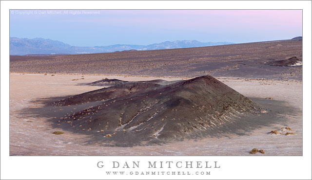
Hill Near Mesquite Flat, Dusk

Hill Near Mesquite Flat, Dusk. Death Valley National Park, California. March 29, 2011. © Copyright G Dan Mitchell – all rights reserved.

Dusk light above a hill near Mesquite Flat in Death Valley, backed by a large alluvial fan from Tucki Mountain.

At the end of this day I was shooting from the top of a low hill in the Valley east of Stovepipe Wells, and there were interesting subjects throughout almost the entire 360 degree panorama around this elevated position. With this in mind, I had chosen to use the long 100-400mm zoom so that I could have some flexibility in composing elements of this huge scene.

I was mainly working with things that were in the large arc to my west (dunes and Cottonwood mountains and base of Tucki Mountain), north (the main Valley and transverse dunes), and east (the mountains running along that edge of the Valley) since the further subjects of the lower Valley were more or less out of sight beyond the alluvial fan that appears in the photograph. But I kept being intrigued by the low, dark hill on the flats below the similar hill on which I was standing. There is a row of them stretching from near the Devils Cornfield area up and across this alluvial fan. As the evening light transitioned towards post-sunset light I saw that the glow from clouds (a bit of which is visible in the distance above the Black Mountains) was lighting this hill and the surrounding flats in an interesting and colorful way.

But I had a little problem. I was still working a number of subjects and once and I really needed to keep shooting that 100-400. 100mm was still too long for this scene, but I didn’t have time to remove it and put on a shorter lens. I figured that I could simply change the camera to vertical orientation, very carefully level the tripod, and include the whole scene in four panning vertical frames that I could stitch together later. People often do this so that they can produce extremely high-resolution image, but that wasn’t my goal at all. In any case, it worked, and not only did I manage to get the shot that needed a wider lens, but as a bonus it is a very high-resolution shot.

G Dan Mitchell Photography | Flickr | Twitter (follow me) | Facebook (“Like” my page) | LinkedIn | Email
Text, photographs, and other media are © Copyright G Dan Mitchell (or others when indicated) and are not in the public domain and may not be used on websites, blogs, or in other media without advance permission from G Dan Mitchell.
Red Rock and Desert Hills

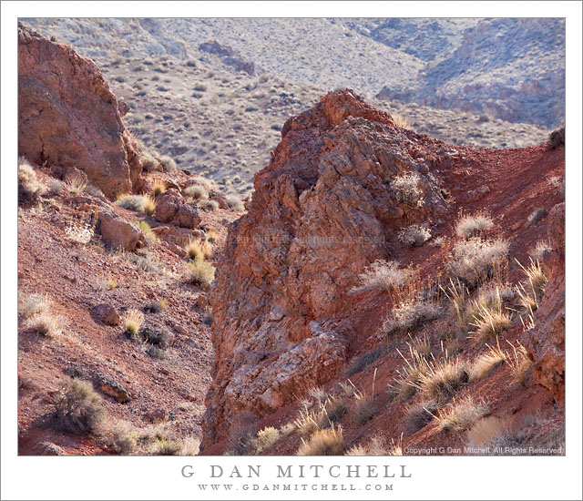
Red Rock and Desert Hills

Red Rock and Desert Hills. Death Valley National Park, California. March 29, 2011. © Copyright G Dan Mitchell – all rights reserved.

A red rock gully among the desert hills of the Panamint Range, Death Valley National Park.

This is anything but an iconic image, but I think that it is emblematic of a certain type of scene that is often seen in Death Valley National Park once you get out of the main Valley and up into the hills, especially during the brief spring season when the light can be a bit softer and the plants a bit (relatively speaking!) greener.

The photograph looks up a broad valley that is visible from along the road that rises from the main road through the Valley and climbs toward the Wildrose Canyon area. Here the elevation is high enough that the dry, sun-baked flat land of the Valley is nowhere to be found. Instead this is a country of large valleys and plateaus, cut in places (mostly at the bottom of canyons) but rocky outcroppings and gullies. This red rock gully is easily visible from the road, though the odds are that most people just drive right by. I had seen it on several drives past this spot before I thought to stop and photograph it, and I was fortunate to be there when the light seemed just right.

G Dan Mitchell Photography | Flickr | Twitter | Facebook | Email
Text, photographs, and other media are © Copyright G Dan Mitchell (or others when indicated) and are not in the public domain and may not be used on websites, blogs, or in other media without advance permission from G Dan Mitchell.
Mesquite Dunes and Cottonwood Mountains

Mesquite Dunes and Cottonwood Mountains

Mesquite Dunes and Cottonwood Mountains. Death Valley National Park, California. March 29, 2011. © Copyright G Dan Mitchell – all rights reserved.

Soft and hazy late-afternoon light on Mesquite Dunes and lower Cottonwood Mountains, Death Valley National Park.

The color of the sand dunes of Death Valley changes radically at different times of the day, in different weather conditions, and even seasonally. Many of the photographs of these dunes – the “Mesquite Dunes” in the middle Valley near Stovepipe Wells – are made in the early morning or in the evening. At those times the dunes take on the colors of sunrise/sunset light (generally very warm yellow to golden colors) or the pre-dawn or (better yet) post-sunset light of the sky, which can include a range of colors from blues to pinks to purples and so on. Judging by photographs you might think that the dunes are brightly and intensely colorful. (Or black and white, but that’s a different story.)

Most of the time the coloration is quite different from what we see at the early and late “edges” of the day. The less saturated colors at other times of day can be a bit more complicated to shoot, but they can also create some wonderful subtle effects if you happen to look in the right place at the right time. Late in the afternoon on this early spring day, there was some haze in the atmosphere – perhaps from some blowing dust and/or some clouds and moisture that had been around earlier. As the sun drops at Mesquite Dunes, it goes behind mountains to the west well before actual sunset. When this happens, the dunes are gently back-lit by soft light from the western sky, and the backlit haze mutes the colors of the dunes and, even more, the distant slopes of the rugged Cottonwood Mountains.

My idea here was to isolate the undulating shapes of the softly lit dunes in front of the background of the very, very muted colors and shapes of the lower Cottonwood Mountains, which are obscured by haze. There is some color in this scene, but it is subdued and edges quite a ways towards pastels.

G Dan Mitchell Photography | Flickr | Twitter | Facebook | Email
Text, photographs, and other media are © Copyright G Dan Mitchell (or others when indicated) and are not in the public domain and may not be used on websites, blogs, or in other media without advance permission from G Dan Mitchell.