
Tag Archives: evening

Seven Sandhill Cranes in Flight

Seven Sandhill Cranes in Flight

Seven Sandhill Cranes in Flight. Merced National Wildlife Reserve, California. February 21, 2011. © Copyright G Dan Mitchell – all rights reserved.

Panoramic photograph of seven sandhill cranes in flight above the Merced National Wildlife Area against a sky full of clearing evening storm clouds.

As I wrote when I posted the first in this series recently, on my return drive from Death Valley to the San Francisco Bay Area I realized that I had enough time to stop at the Merced National Wildlife Reserve just before sunset, so I altered my route so that I could drive out on Sandy Mush Road (I still love writing that road name!) to the Reserve and do a little bit of photography. Although I’ve done a bit of wildlife photography, it isn’t my main thing and this is the first year that I’ve headed out to the migratory bird areas of California’s Great Central Valley – so this is a relatively new experience for me.

I had seen video and photographs of the morning “fly out” and evening “fly in” at several locations in the Valley and was hoping that I might get to witness something like this. That didn’t happen, though at one point I saw and heard the event taking place at pond a ways north of the road I had stopped on. I’m getting the impression that this experiences probably requires some persistence and repeat visits. However, I did find a field that was filled with scores of sandhill cranes. I quietly stopped my car, grabbed the camera with a long lens, and got out on the side away from the field and watched quietly. Even these attempts at quiet weren’t enough as the birds began to edge a ways away from the roadside edge of the field before they quieted again and went about their business.

Before long a few small groups began to take flight. I was fortunate that a storm had just passed through and the remnant clouds were beginning to clear in the west, both providing a dramatic background in that direction and allowing a bit of colorful light to strike clouds directly above and to my east. This brings up an observation about photographing birds – admittedly from a photographer who isn’t quite an expert on this but who likes to try to learn… thinking about what is behind and around the birds is often as important as getting the birds themselves into the frame. I like to say that in this series I was thinking about the clouds almost as much as I was thinking about the birds. As I continue to practice and learn how to photograph these animals in flight, I find that I can begin to simultaneously think about keeping them framed in the viewfinder in interesting ways and remain aware of what else is in the frame as I pan.

Special thanks to my friend Tom Clifton for helping me identify some of the other birds I photographed on this visit.

G Dan Mitchell Photography | Flickr | Twitter | Facebook | Email
Text, photographs, and other media are © Copyright G Dan Mitchell (or others when indicated) and are not in the public domain and may not be used on websites, blogs, or in other media without advance permission from G Dan Mitchell.
Canon EOS 5D Mark II (at B&H)
Canon EF 100-400mm f/4.5-5.6 L IS USM at 400mm (at B&H)
ISO 400, f/5.6, 1/3200 second


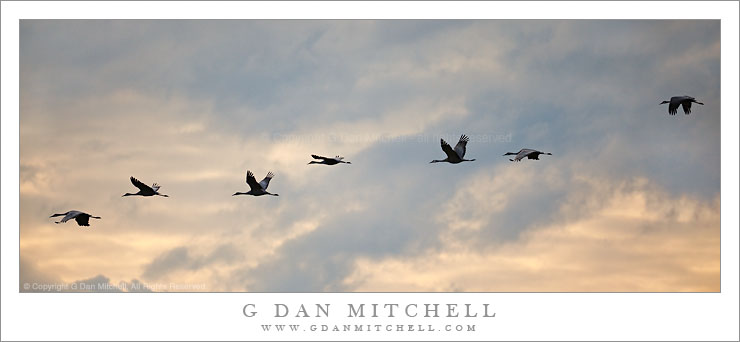
Sandhill Cranes in Flight, Evening

Sandhill Cranes in Flight, Evening

Sandhill Cranes in Flight, Evening. Merced National Wildlife Area, California. February 21, 2011. © Copyright G Dan Mitchell – all rights reserved.

Five sandhill cranes take flight above the Merced National Wildlife Area in evening light.

Migratory birds have always been a subject that I’ve been aware of, but that I haven’t really paid enough attention to. Intellectually I know of their amazing travels between arctic and more temperate regions and I had heard about their appearance in California each winter season. I recall one magical evening a few years back when I began a long drive from the San Francisco Bay Area to Seattle late on a winter day, and as I travelled up the Sacramento Valley at twilight I saw huge flocks of birds and thought that I’d like to try to photograph this scene. I’ve seen and photographed a few interesting birds such as egrets and pelicans. But I somehow managed to mostly remain uninformed about their presence not far from where I live.

This season several things came together, seemingly by chance, to encourage me to actually make the effort to get out into California’s Great Central Valley to see (and hear!) the birds. The first was a chance meeting with one of my colleagues in front of the college espresso stand one morning. We were having a casual conversation and she mentioned that she had been out in the Cosumnes River area looking for birds recently. We talked a bit more and I asked her for more information. Being a librarian, she provided me with lots of information, including details of how to find some interesting places out there. A day or two later I found my way out to that part of the Valley and saw, for the first time close-up, the flocks of winter birds… and I was hooked. Within a few weeks I saw posts on the Chuq 3.0 blog where Chuq wrote about his photography of these birds. Then I saw a couple videos at Michael Frye’s blog that captured the “fly in” and “fly out” phases at the Merced National Wildlife Area. (This place is located out on a road that has to have my all-time favorite Central Valley road name: Sandy Mush Road ;-)

Fast forward a week or two and I was returning from shooting for four days in Death Valley, and driving into the Central Valley near Bakersfield. I looked at my watch and realized that I could probably make a small detour and be at the Merced National Wildlife Area before sunset. So I headed up highway 99 (rather than the more usual route up highway 5), found the turn off to Sandy Mush Road, and arrived at the area an hour or so before sunset on an evening when the clouds from a departing cold front lingered. I basically had no idea where I was going, since I had done literally no prior research other than finding the location via my iPhone. As I arrived in the general area I found a large field filled with what seemed like several hundred sandhill cranes. Slowly and quietly I stopped my car and got out on the side away from the birds and began to watch. I never did get to see the fly-in up close (though I could see a huge cloud of birds landing at a pond north of my position) but some of these cranes did depart from time to time, and I was able to photograph this group of the magnificent birds against the clouds in the western sky.

G Dan Mitchell Photography | Flickr | Twitter | Facebook | Email
Text, photographs, and other media are © Copyright G Dan Mitchell (or others when indicated) and are not in the public domain and may not be used on websites, blogs, or in other media without advance permission from G Dan Mitchell.
Winter Evening Sky, Panamint Range, Death Valley

Winter Evening Sky, Panamint Range, Death Valley

Winter Evening Sky, Panamint Range, Death Valley. Death Valley National Park, California. February 18, 2011. © Copyright G Dan Mitchell – all rights reserved.

Winter clouds fill the evening sky above the eastern slopes of the Panamint Range in Death Valley National Park.

After the long drive from the San Francisco Bay Area I arrived at Stovepipe Wells in Death Valley and set up my camp in the mid afternoon and hung out a bit, thinking about the prospects of late afternoon and evening shooting. Because a weather front was coming in (the forecast called for a chance of rain in the Valley and pretty much certain light snow over the passes) the clouds were increasing, in many directions heading past the point of “picturesque” and more towards “socked in.” I was hoping for some evening light – or early rain? – but it seemed less promising as evening approached. In circumstances like these I may come up with a few possible shooting alternatives ahead of time, watch as conditions develop, and make a last-minute decision about where to go based on observations and hunches.

So, late in the afternoon I stopped near Death Valley Dunes and worked to line up some long shots that filled the background of the dunes with the rugged shapes of the Grapevine Mountains, and then headed towards the junction with the road to Scotty’s Castle to try to figure out if the light held more promise to the north or the south. It didn’t look totally promising in either direction, but I thought that I might be able to make something out of the haze to the south as the ridges on both sides of the Valley receded, especially if a bit of glow in the sky turned up right at sunset. So, south it was.

I drove just a little ways in that direction to a point where the road curves a bit towards the east to travel around the northernmost area of salt flats in what I think of as the lower valley – this is the area a bit south of the Salt Creek cutoff. From here there is a fairly open view all the way down to the end of the Valley, and it looked like the clouds were going to evolve in some interesting ways. It didn’t look like I would see a gaudy, brilliantly colorful sunset, but something more subtle and quiet looked like it might happen. As the light began to fade I made a series of photographs whose subject was largely the sky and the atmospheric recession along the Panamint Range (shown here) on the west side of the Valley and the mountains just beyond Furnace Creek.

G Dan Mitchell Photography | Flickr | Twitter | Facebook | Email
Text, photographs, and other media are © Copyright G Dan Mitchell (or others when indicated) and are not in the public domain and may not be used on websites, blogs, or in other media without advance permission from G Dan Mitchell.

Glacial Erratics and Trees, Lembert Dome

Glacial Erratics and Trees, Lembert Dome

Glacial Erratics and Trees, Lembert Dome. Yosemite National Park, California. June 5, 2010. a© Copyright G Dan Mitchell – all rights reserved.

Glacial erratics and trees at the base of Lembert Dome, Tuolumne Meadows, Yosemite National Park.

This photograph was made last spring in early June, when I drove over Tioga Pass on a quick one-day jaunt right around the time that the road was re-opened for the season after its annual winter closure. The road opened a bit later than usual in 2010 due to above average and late snow fall, and when I crossed there was as much or more snow than I recall seeing up there.

This was one of my marathon drive days. I started well before dawn in the San Francisco Bay Area and arrived in Yosemite in the very early morning and without any concrete plan – except that the ideas of visiting waterfalls and possibly getting up to Tioga Pass were on my mind. I did stop near the Valley first, where I made a series of photographs of Cascade Creek in virtually full flow. After doing this and making a very brief visit to the Valley, I decided to visit the high country along Tioga Pass road. I went just over the pass before turning back. There was so much snow still around that in most places it still looked much more like winter than like early June.

I finally started heading back to the west, as my plan was to return late to the SF Bay Area. As I left the pass and started down toward Tuolumne Meadows the light began to get “interesting” as the sun dropped lower in the west and some high clouds occasionally softened the light. As I drove past Lembert Dome I thought of photographing these glacial erratics that sit on the apron at the bottom of the dome before making one last stop to photograph snow-covered Tuolumne Meadow in the day’s last light.

G Dan Mitchell Photography | Flickr | Twitter | Facebook | Email
Text, photographs, and other media are © Copyright G Dan Mitchell (or others when indicated) and are not in the public domain and may not be used on websites, blogs, or in other media without advance permission from G Dan Mitchell.