Tag Archives: hills

Rocky Point, Sea Stacks

Rocky Point, Sea Stacks - Sea stacks near Rocky Point on a foggy evening along the Big Sur coastline.

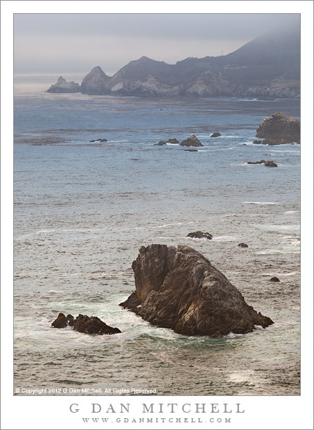
Rocky Point, Sea Stacks. Big Sur Coastline, California. August 13, 2012. © Copyright 2012 G Dan Mitchell – all rights reserved.

Sea stacks near Rocky Point on a foggy evening along the Big Sur coastline.

This photograph was made along the Big Sur coastline roughly in the area between the Rocky Creek and Bixby Creek bridges, about as far south as we managed to get while wandering around before a 8:00 p.m. dinner reservation back in Monterey. (Hey, it was my birthday!) The Peninsula extending into the Pacific in the upper section of the frame could be any of probably hundreds of similar peninsulas where the steep hills of the Big Sur coast drop to meet the ocean – but this one happens to be Rocky Point. The foreground sea stack could be any of thousands (or tens of thousands? I see perhaps a dozen or more in this scene alone…) of similar features found almost anywhere you look along this coast.

The light was both interesting and challenging. In most cases, I would rather try to photograph this interesting, foggy atmosphere than shoot perfect blue-sky conditions. (The latter can occur, though not as often as photography might suggest! Fog is more common.) It was very late in the day, probably around 7:00 p.m, and the sun was low and mostly hidden behind the off-shore fog bank. Here and there the fog backed off a bit from the shoreline or thinned a bit, and slightly more light appeared. The sea stack was in one such spot, and around and beyond the point there is also a bit more light.


G Dan Mitchell is a California photographer and visual opportunist. His book, “California’s Fall Color: A Photographer’s Guide to Autumn in the Sierra” (Heyday Books) is available directly from him.

G Dan Mitchell: Blog | Bluesky | Mastodon | Substack Notes | Flickr | Email


All media © Copyright G Dan Mitchell and others as indicated. Any use requires advance permission from G Dan Mitchell.

Big Sur Coast at Soberanes Point

Big Sur Coast at Soberanes Point - Evening fog comes in as the rugged Big Sur coast stretches north from near Soberanes Point, California
Evening fog comes in as the rugged Big Sur coast stretches north from near Soberanes Point, California

Big Sur Coast at Soberanes Point. Big Sur, California. August 13, 2012. © Copyright 2012 G Dan Mitchell – all rights reserved.

Evening fog comes in as the rugged Big Sur coast stretches north from near Soberanes Point, California.

Talk about photographic geekiness – we ended up making photographs on my birthday! Because of a variety of factors, this turned out to be a bit of a low key birthday this year – despite some earlier plans to do all sorts of wild and crazy things. (Completing the JMT or going to Alaska will perhaps wait a bit… ;-) After a quiet and lazy morning we decided to head down to the Monterey area for a birthday dinner, which turned out to be quite nice by the way. (Thanks, Patty!)

Since we arrived a few hours before our dinner reservation. After stalling around a bit, thinking about this and that option, we decided to do the usual, obvious thing and head south on the Highway 1, the “coast highway,” into the upper portion of the Big Sur coastline area. While it is a very familiar area and one I visit a lot, it is never the same twice – all of the variables of light and atmosphere and season and weather are in play and you almost never know quite what you’ll find. On this early evening, the most important factor was that the edge of the ocean fog was positioned very close to the shore. This meant that sometimes it extended just a bit inland, creating light that ranged from slightly luminous to gray and murky, while in other areas it was just offshore, allowing light to hit the coast and even to light the surface of the ocean a bit. Here at the cove where the creek comes down Soberanes Canyon to meet the ocean, we found one of those boundaries – quite gray along the immediate coast in the distance, sunlight on the bluffs and hills at the right, and that wonderful boundary light in between. And above that, the barely perceptible difference between the soft clouds of fog and the light blue of the late-day sky.

G Dan Mitchell is a California photographer whose subjects include the Pacific coast, redwood forests, central California oak/grasslands, the Sierra Nevada, California deserts, urban landscapes, night photography, and more.
Blog | About | Flickr | Twitter | FacebookGoogle+ | 500px.com | LinkedIn | Email

Text, photographs, and other media are © Copyright G Dan Mitchell (or others when indicated) and are not in the public domain and may not be used on websites, blogs, or in other media without advance permission from G Dan Mitchell.

Lee Vining Canyon and Mono Craters, Morning

Lee Vining Canyon and Mono Craters, Morning - Morning clouds and haze over Mono Craters, as seen from the upper elevation of Lee Vining Canyon.
Morning clouds and haze over Mono Craters, as seen from the upper elevation of Lee Vining Canyon.

Lee Vining Canyon and Mono Craters, Morning. Eastern Sierra Nevada, California. July 14, 2012. © Copyright 2012 G Dan Mitchell – all rights reserved.

Morning clouds and haze over Mono Craters, as seen from the upper elevation of Lee Vining Canyon.

East of Tioga Pass, highway 120 (a.k.a. “Tioga Pass Road”) descends relatively gently past Tioga Lake and then Ellery Lake before it drop precipitously down the eastern escarpment of the Sierra Nevada through Lee Vining Canyon on its way to the junction with highway 395 just south of the town of Lee Vining. I’ve driven over it for years, going back and forth between my home in the San Francisco Bay Area and the east side of the Sierra, so I should be fairly nonchalant about it by now – but every so often as I pass over the route (most often looking down into the canyon from above) I wonder whatever possessed people to think that it would be a good idea to route a road across the talus fields and across the steep headway of this canyon.

During last week’s photographic trip to the Tuolumne Meadows area of Yosemite National Park I went over the pass twice. The first time was to scout out some possible shooting locations around Mono Lake – OK, and to get an espresso at Latte Da in Lee Vining – and the second was the following morning when I returned to shoot one of these locations. The night before I had moved my camp to Ellery Lake (it is a long story), which put me a bit closer to Mono Lake, so I was up well before dawn and at the lake before sunrise. After photographing my primary subject there right at dawn, I stuck around long enough to photograph the early morning light and haze above the lake, then headed back to break up my camp before heading home. As I crossed that headwall high up above Lee Vining Canyon, I looked east toward the Mono Craters. Looking that way is pretty much a habit, but I rarely find it to present anything that I want to photograph. This morning was different. I quickly found a turn-out and drove back to this spot. A nice haze filled the air (I like atmospheric haze for photography!), a few clouds clustered around ridges just beyond the volcanic Mono Craters, and a high line of clouds from monsoonal flow were in the far distance, with the steep walls of Lee Vining Canyon backlit and almost seen entirely in silhouette.

G Dan Mitchell is a California photographer whose subjects include the Pacific coast, redwood forests, central California oak/grasslands, the Sierra Nevada, California deserts, urban landscapes, night photography, and more.
Blog | About | Flickr | Twitter | FacebookGoogle+ | 500px.com | LinkedIn | Email

Text, photographs, and other media are © Copyright G Dan Mitchell (or others when indicated) and are not in the public domain and may not be used on websites, blogs, or in other media without advance permission from G Dan Mitchell.

Iris Blossom, Japanese Garden

Iris Blossom, Japanese Garden - A new iris blossom emerges against a background of summer greenery.
A new iris blossom emerges against a background of summer greenery.

Iris Blossom, Japanese Garden. Portland, Oregon. July 3, 2012. © Copyright 2012 G Dan Mitchell – all rights reserved.

A new iris blossom emerges against a background of summer greenery.

I was in Portland, Oregon during the past week on a family visit. I’ve been to and through Portland before, but this was the first time I have been able to stay there for a substantial amount of time. Although this was not primarily a photographic trip – I didn’t even carry a tripod! – I did keep a camera with me, and I had some opportunities to do some informal photography while getting to know the place. I also had a chance to find out just how much of a garden city Portland is. During five days in the city I think we visited at least that many gardens, ranging from formal rose gardens (for which the city is famous), small and informal gardens, several Japanese and Chinese gardens, gardens around homes and historic buildings, and more.

I made this photograph of what I’m pretty certain is an iris (I’m actually very bad at plant identification…) while walking around one such garden. Shooting in shade on an overcast afternoon, the light was close to the limit of what I would want to try to shoot handheld, but I crouched down low and I think I managed to make it work. I like the slightly curving shape of the stem, with its partially unwrapped sections, and the flower itself illuminated by soft light from the sky.

G Dan Mitchell is a California photographer whose subjects include the Pacific coast, redwood forests, central California oak/grasslands, the Sierra Nevada, California deserts, urban landscapes, night photography, and more.
Blog | About | Flickr | Twitter | FacebookGoogle+ | 500px.com | LinkedIn | Email

Text, photographs, and other media are © Copyright G Dan Mitchell (or others when indicated) and are not in the public domain and may not be used on websites, blogs, or in other media without advance permission from G Dan Mitchell.