Tag Archives: kern

Backpackers Near Milestone Basin

Backpackers, Near MIlestone Basin

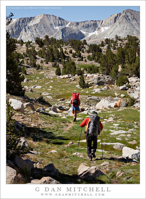
Backpackers, Near Milestone Basin. Sierra Nevada, California. August, 2010. © Copyright 2010 G Dan Mitchell – all rights reserved

Two backpackers descend through sub-alpine meadows toward the peaks of the Great Western Divide near Milestsone Basin, Sequoia National Park.

My two friends, Caroline and Owen, head through a lovely sub-alpine meadow toward the peaks of the Great Western Divide and the upper Kern River drainage of the Sierra Nevada in early August. (When doing backpacking photography it is always good to be accompanied by friends with colorful gear! My clothing color scheme is not conducive to photography, consisting mostly of colors that match the rocks, grasses, and dirt…)

This is a spectacular and less-visited area of the Sierra, being very high and at least two days from any trailhead – and those trailheads lead over very high Sierra crest passes. We hit it at perhaps the peak of its seasonal beauty – despite the clouds of mosquitoes, everything was tremendously green. Even in the late morning hour – not typically the time for photography – the scene was quite something. Our trail here passed through a succession of small, intimate meadows surrounded by rolling hills and filled with scattered glacial rocks, occasionally passing by small lakes and tarns — perhaps my favorite kind of Sierra terrain!


G Dan Mitchell is a California photographer and visual opportunist whose subjects include the Pacific coast, redwood forests, central California oak/grasslands, the Sierra Nevada, California deserts, urban landscapes, night photography, and more.
Blog | About | Flickr | Twitter | Facebook | Google+ | 500px.com | LinkedIn | Email

Text, photographs, and other media are © Copyright G Dan Mitchell (or others when indicated) and are not in the public domain and may not be used on websites, blogs, or in other media without advance permission from G Dan Mitchell.

Evening, Unnamed Lake and the Great Western Divide

Evening, Unnamed Lake and the Great Western Divide

Evening, Unnamed Lake and the Great Western Divide. Sequoia National Park, California. August 2. 2010. © Copyright G Dan Mitchell – all rights reserved.

Evening sky over the Great Western Divide reflected in an unnamed alpine lake, Sequoia National Park, California.

I don’t know quite what to say about this area of the Sierra located just east of the Great Western Divide in the upper reaches of the Kern River drainage – I’ve been very close to here on many previous trips, but I never quite managed to hop the intervening ridge even though I’ve thought vaguely about visiting this area for decades and I once passed through the lower reaches of it, more or less by accident and completely unaware of what was just upstream.

A group of us traveled over Kearsarge Pass (11,700’+) and Forrester Pass (13, 200′) to arrive in the upper Kern at Tyndall Creek along the JMT. (I think the general area is also known as the “bighorn plateau.”) I’ve been here on several previous occasions while heading to or circumnavigating Mt. Whitney. While I’ve gone east (to exit over the very rough Shepherd Pass at 12,000′) I’ve not really explored west and north of this area. Our general plan on this trip was to rectify that, specifically by visiting remote and very high Lake South America. After wandering up a mosquito-infested valley, climbing its headwall, and then dropping to a lake just below the saddle we made it to Lake South America. We had originally planned to stay here overnight, but the very barren and rocky surroundings didn’t attract us in the end, so we decided to head on to the west and south.

After a bit of a walk on a somewhat rough trail (which got much rougher later on) we arrived at a series of timberline lakes overlooking the Great Western Divide, which towered above us to the west. There is much I could say about this area, but I’ll limit myself to a few comments… and not name the specific location we visited. We finally found a sandy camping spot between a few lakes and tarns – it was surrounded by stunning alpine views ranging from the lakes themselves and the surrounding rocky meadows and clumps of trees to the jagged and high peaks to our west. The next morning we followed a very faint trail down the canyon, passing almost continuously through astonishing scenery featuring intimate, granite-surrounded meadows and small lakes.

I must go back. It won’t be easy. I’ll want to carry a bit more photography gear than I carried on this trip, and I’ll want to stay a day or two longer. And the location is two to three days from the nearest trailheads, all of which take you over some very high passes.

This photograph is not in the public domain and may not be used on websites, blogs, or in other media without advance permission from G Dan Mitchell.

G Dan Mitchell Photography
About | Flickr | Twitter | Facebook | Google+ | 500px.com | LinkedIn | Email

Text, photographs, and other media are © Copyright G Dan Mitchell (or others when indicated) and are not in the public domain and may not be used on websites, blogs, or in other media without advance permission from G Dan Mitchell.

(Basic EXIF data is available by “mousing over” large images in blog posts. Leave a comment if you want to know more.)


Alpine Tarn, Great Western Divide

Alpine Tarn, Great Western Divide

Alpine Tarn, Great Western Divide. Sequoia National Park, California. August 2, 2010. © Copyright 2010 G Dan Mitchell – all rights reserved.

The peaks of the Great Western Divide tower above a small alpine tarn reflecting afternoon light, Sequoia National Park.

Our original goal on this late-July, early-August southern Sierra backpacking trip was to be Lake South America, a very high, very barren, and very remote lake in the upper reaches of the Kern River basin in Sequoia National Park. Believe it or not, I’ve thought of visiting this lake for decades, ever since a very early pack trip on which I planned to go there but ended up bypassing the lake and exiting in Mineral King. (Mineral King is nowhere near Lake South America. It is a long story… :-)

After staying on the JMT at Tyndall Creek the night before, we headed up over the ridge to the northwest in the morning. After walking up a broad and mosquito infested marshy valley, we climbed the steep headwall at the upper end of this valley and looked down at a lake on the other side. Just beyond this lake was Lake South America. Oddly, when we arrived we were not tremendously excited by the scene. Yes, it is a wild and high place in the heart of the Sierra, but for some reason it seemed a bit like many other high, barren lakes we had visited before… and we decided to make only a very brief visit and then move on.

This turned out to be a great decision. After returning to the lake that we had passed just prior to the short side trip to Lake South America, we picked up a trail heading towards the head waters of the Kern and eventually dropped down to a set of about four beautiful lakes just below treeline. The lakes, unnamed as far as I can tell, seem to sit at the edge of a valley with the high and jagged peaks of the Great Western Divide just beyond, providing one of the most rugged and spectacular scenes I’ve encountered in the Sierra. Needless to say, we decided to camp here despite the mosquito hatch that was currently underway.

This photograph is not in the public domain and may not be used on websites, blogs, or in other media without advance permission from G Dan Mitchell.

G Dan Mitchell Photography
About | Flickr | Twitter | Facebook | Google+ | 500px.com | LinkedIn | Email

Text, photographs, and other media are © Copyright G Dan Mitchell (or others when indicated) and are not in the public domain and may not be used on websites, blogs, or in other media without advance permission from G Dan Mitchell.

(Basic EXIF data is available by “mousing over” large images in blog posts. Leave a comment if you want to know more.)


Cascade, Tyndall Creek

Cascade, Tyndall Creek

Cascade, Tyndall Creek. Sequoia National Park, California. August 1. 2010. © Copyright G Dan Mitchell – all rights reserved.

High in the Upper Kern River drainage, water dashes over the rocks of Tyndall Creek.

Tyndall Creek is in one of my most favorite areas of the Sierra Nevada. It runs between Shepherd Pass (located on the Sierra Crest a bit north of Mount Whitney) and the upper reaches of the Kern River in Sequoia National Park. It begins, more or less, in a small, barren lake right on the crest at the verge of the drop-off into Shepherd Pass, flows gently westward through alpine rock gardens as it descends towards timberline, and then drops more quickly to join the Kern a few miles later. It crosses the John Muir Trail where one encounters almost the first trees after descending from 13,200′ Forrester Pass to the north. Quite a few JMT travelers camp at this spot – partly because of the shelter of the trees and partly because of the terraced rocks over which the creek passes here.

G Dan Mitchell Photography
About | Flickr | Twitter | FacebookGoogle+ | 500px.com | LinkedIn | Email

Text, photographs, and other media are © Copyright G Dan Mitchell (or others when indicated) and are not in the public domain and may not be used on websites, blogs, or in other media without advance permission from G Dan Mitchell.

(Basic EXIF data is available by “mousing over” large images in blog posts. Leave a comment if you want to know more.)