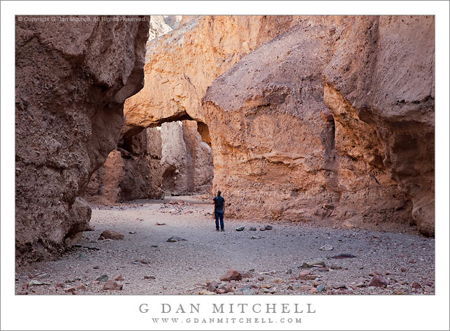
A hiker pauses below the bridge in Natural Bridge Canyon, Death Valley National Park, California.
I visited this canyon and its natural bridge on my late-March visit to Death Valley. The Nature Bridge canyon is located just a bit north of Badwater, and after a short drive up the alluvial fan to the trailhead it is an easy hike up an impressively narrow and deep canyon to the large, blocky bridge. I like to save the canyons for mid-morning or late-afternoon shooting, since the light here can actually improve a bit further away from the sunrise/sunset edges of the day – the direct light is block by the tall canyon walls.
This canyon is narrow, but not as narrow as some of the other popular canyons with trails such as Mosaic Canyon, in which there a spots where two people cannot pass. Compared to that this canyon is much wider in most spots, perhaps 20 feet or more in places. Nonetheless the vertical and tall walls of the lower section of the canyon block out most of the sky and give a feeling of being somewhat closed in.
G Dan Mitchell is a California photographer and visual opportunist. His book, “California’s Fall Color: A Photographer’s Guide to Autumn in the Sierra” (Heyday Books) is available directly from him.
Black and white photograph of “the “Grandstand” formation standing in the middle of the Racetrack Playa, Death Valley National Park, California.
The Grandstand is a striking formation located a distance out onto the flat expanse of the Racetrack Playa, the location of the famous “moving rocks” in Death Valley National Park. The formation is located not far from where the road first reaches the playa and it is only a short walk. As I recall, it is just the tip of a large “hill” that is mostly buried beneath the very deep silt that was washed down from the surrounding mountains to form the playa. It has a shape this is vaguely “castle-like,” with several “turrets” that tower above the flat surrounding terrain and invite quite a few visitors to climb to the top. (The Grandstand is located at nearly the opposite end of the playa from the location of the largest concentration of moving rocks.)
I think that the Grandstand makes an interesting photographic subject, even though the thing most people come to see and photograph is the phenomenon of the moving rocks. I often plan to stop there and photograph in mid to late afternoon – when light on the rocks is interesting and photogenic, but before the “good light” begins further south on the playa and it is time to photograph the rocks and their tracks. It can also be a compositional element in photographs of the rocks at the south end of the playa, especially when you shoot with a long lens.
This photograph is not in the public domain and may not be used on websites, blogs, or in other media without advance permission from G Dan Mitchell.
Technical Data:
Canon EOS 5D Mark II
Canon EF 24-105mm f/4 L IS USM at 55mm
ISO 200, f/11, 1/320 second
keywords: death valley, national, park, california, usa, north america, nature, scenic, travel, landscape, the, grandstand, hill, rock, boulder, formation, race, track, racetrack, playa, sky, clouds, black and white, monochrome, geology, stock, light
Sunset clouds above the patterned salt flats near Badwater, Death Valley National Park, California.
This photograph was made in the evening at the “secret” spot on the salt flats just south of Badwater. Reports and photographs from this location a couple weeks ago indicated that it had been flooded by earlier heavy rains, but by the time of my visit there was little standing water left here, with the exception of a few open spots (one seen in the middle distance on the salt flats) – though it did appear that the flats might still be wet beneath the salt crust. Walking on this was an odd experience that reminded me a bit of walking on newly frozen winter ice. The appearance of the salt flats was quite changed by the water. Typically the ridges between the flat “polygon” sections of the salt are more distinct, being as tall as a few inches and sometimes almost seeing to break over one another like the edges of ice floes. But at this stage the flats are almost, well, flat.
Shooting this scene in the evening often provides a few technical challenges. In the past I’ve shot from a lower camera position in order to get a closer view of the salt. This time I decided to place the camera bit higher so that I could capture a larger expanse of the salt flat texture. Another issue is the color of the salt. We “know” that salt is white, and when one walks on the playa it registers as white to the eyes/mind. But if you observe carefully – or look at a photograph later – you find out that this salt is anything but white, mostly because it is illuminated entirely by the open sky and therefore picks up the sky coloration. When the sky is clear the salt can become so blue that corrections are needed, in my opinion, during post-processing. On this evening the blue was not as pronounced since the colorful clouds balanced it out to some extent. A third issue is the tremendous dynamic range of the scene, ranging from some very bright sky below the clouds near the left side of the frame, through the much less brightly-lit salt flat, to the very dark foothills on the horizon at the right. In order to manage this I had to do two things. First, instead of using a graduated neutral density filter to lighten the foreground and control sky brightness, I made two exposures one stop apart and combined them in post. Secondly, I used layers to separately adjust sections of the image, primarily differentiating between the salt (which need to be lightened up a bit) and the sky (where the brightest areas needed to be controlled).
This photograph is not in the public domain and may not be used on websites, blogs, or in other media without advance permission from G Dan Mitchell.
Sunset light on lower reaches of the Amargosa Range and the Kit Fox Hills above the Transverse Dunes, Death Valley National Park, California.
The Amargosa Range lies east of Death Valley and the Death Valley Dunes, and its foothills (called the “Kit Fox Hills,” if I’m not mistaken) here from a backdrop for the “transverse dunes,” the lower eastern portion of the Death Valley Dunes near Stovepipe Wells. The dunes turn all sorts of interesting colors at and just after sunset on evenings when the light is just right, and the evening light brings out colors in the further hills and gullies that are generally washed out in the harsh midday light.
To get an idea of the scale of the scene consider that the photograph was made with a rather long focal length of nearly 400mm and that the very subtle line along the base of the hills is the roadway running north towards Scotty’s Castle. Walking out to the dunes along the lower edge of the photograph might take a half hour or so.
This photograph is not in the public domain and may not be used on websites, blogs, or in other media without advance permission from G Dan Mitchell.
Technical Data:
Canon EOS 5D Mark II
Canon EF 100-400mm f/4.5-5.6 L IS USM at 370mm
ISO 200, f/8, 1/50 second
keywords: kit fox, hills, mountains, amargosa, range, alluvial, fan, desert, transverse, dunes, mesquite, gully, geology, grapevine, foothills, shadow, sunset, dusk, wash, evening, death valley, national, park, california, usa, north america, travel, scenic, wilderness, landscape, nature, barren, light, stock
Photographer and visual opportunist. Daily photos since 2005, plus articles, reviews, news, and ideas.
Manage Consent
To provide the best experiences, we use technologies like cookies to store and/or access device information. Consenting to these technologies will allow us to process data such as browsing behavior or unique IDs on this site. Not consenting or withdrawing consent, may adversely affect certain features and functions.
Functional
Always active
The technical storage or access is strictly necessary for the legitimate purpose of enabling the use of a specific service explicitly requested by the subscriber or user, or for the sole purpose of carrying out the transmission of a communication over an electronic communications network.
Preferences
The technical storage or access is necessary for the legitimate purpose of storing preferences that are not requested by the subscriber or user.
Statistics
The technical storage or access that is used exclusively for statistical purposes.The technical storage or access that is used exclusively for anonymous statistical purposes. Without a subpoena, voluntary compliance on the part of your Internet Service Provider, or additional records from a third party, information stored or retrieved for this purpose alone cannot usually be used to identify you.
Marketing
The technical storage or access is required to create user profiles to send advertising, or to track the user on a website or across several websites for similar marketing purposes.