
Tag Archives: peak

Alpenglow, Mammoth Peak

Alpenglow, Mammoth Peak

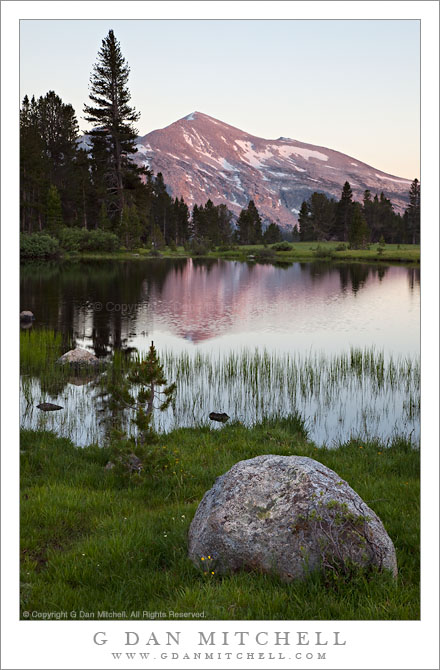
Alpenglow, Mammoth Peak. Yosemite National Park, California. July 22, 2010. © Copyright G Dan Mitchell – all rights reserved.

Alpenglow lights the face of Mammoth Peak beyond a small tarn near the summit of Tioga Pass, Yosemite National Park.

This was very close to the last exposure I made on this productive late-July day last year. After photographing for a few hours in the vicinity of Tioga Pass, I ended up right at the pass as the day came to an end. Braving hordes of mosquitos – comes with the territory! – I worked the area around the pass itself, building compositions out of juxtapositions of the water in the small meltwater ponds, shoreline meadow and boulders, grasses growing along the edge of the water, the surrounding pine forests, and the more distant peaks of Kuna Crest. In this photograph, what is very nearly the very last direct light of the day is bathing the slopes of Mammoth Peak, which still had a fair amount of snow on its flanks even in late July.

This scene posed a few technical challenges. First, there is obviously a great distance between the foreground granite boulder and the very distance mountain. I wanted the foreground to be in optimal sharpness, so I used a relatively small aperture to maintain sufficient sharpness on the far ridge. There was also a fairly large dynamic range in the scene, ranging from soft but direct light on the snow fields of the peak to the dark areas within the forest on the other side of the pond. I wasn’t certain that I’d be able to handle the full dynamic range in one exposure, so I made three – one longer exposure to get a bit more light from the shadows and another shorter one on the dark side to avoid blowing out the brighter areas of the sky. In post, I discovered that there was enough detail in the shadows that I could get everything I needed from a single exposure, though I had to do some work with curves to get create an image the conforms more closely to the way I saw the scene at the time.

G Dan Mitchell Photography | Flickr | Twitter (follow me) | Facebook (“Like” my page) | LinkedIn | Email
Text, photographs, and other media are © Copyright G Dan Mitchell (or others when indicated) and are not in the public domain and may not be used on websites, blogs, or in other media without advance permission from G Dan Mitchell.
Mammoth Peak Reflected in Tioga Tarn

Mammoth Peak Reflected in Tioga Tarn

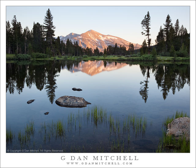
Mammoth Peak Reflected in Tioga Tarn. Yosemite National Park, California. July 22, 2010. © Copyright G Dan Mitchell – all rights reserved.

Mammoth Peak in sunset light, reflected in the still surface of Tioga Tarn, Tioga Pass, Yosemite National Park.

This view of Mammoth Peak on Kuna Crest in the Yosemite High Country from the Tioga Tarns at the top of Tioga Pass is a classic Sierra Nevada scene. The foreground tarns are lush green in the early summer after the snow melts out and fall into shadow early in the evening as the sun drops behind the ridge between this area and Gaylor Lakes. Mammoth Peak, however, has an almost unobstructed line of sight to the west, so this peak continues to hold the sunset light until the last possible minute. (Don’t let the peaceful appearance of the scene fool you – I was being devoured by clouds of mosquitos as I made these exposures.)

In order to deal with the extremely large dynamic range between the Mammoth Peak snow fields in direct sun and the very dark shadows of the nearby forest I resorted to exposure blending and a few other post-processing techniques. With exposure blending, I make two exposures, one optimized for the brightest areas of the scene and the second a slightly longer exposure to capture a bit more of the shadow detail. In post I began with the darker frame, since that presented Mammoth Peak the way I remembered it. Then I placed to other exposure beneath it and used a mask layer to reveal some of the lighter areas from the lower layer.


G Dan Mitchell is a California photographer and visual opportunist. His book, “California’s Fall Color: A Photographer’s Guide to Autumn in the Sierra” (Heyday Books) is available directly from him.

G Dan Mitchell: Blog | Bluesky | Mastodon | Substack Notes | Flickr | Email


All media © Copyright G Dan Mitchell and others as indicated. Any use requires advance permission from G Dan Mitchell.

‘Rim of the World’ Overlook, Morning

'Rim of the World' Overlook, Morning

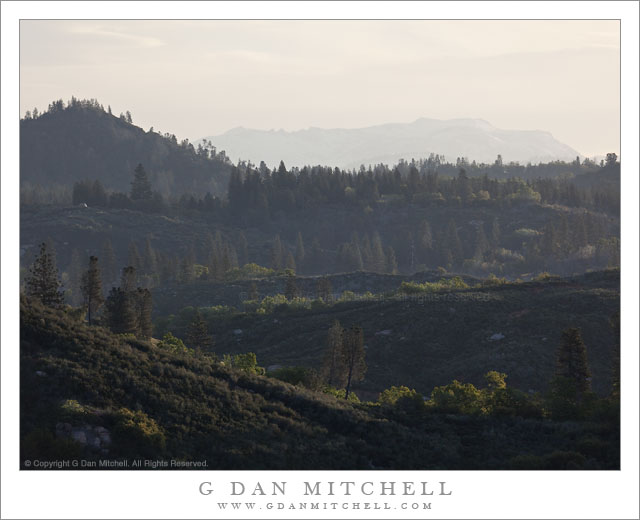
‘Rim of the World’ Overlook, Morning. Sierra Nevada, California. May 7, 2011. © Copyright G Dan Mitchell – all rights reserved.

The view toward Yosemite and the High Sierra from the ‘Rim of the World’ overlook above the Tuolumne River canyon along highway 120.

‘Rim of the World’ is the name given to a scenic overlook above the deep valley of the Tuolumne River along route 120, the northern route into Yosemite National Park. It is something of an odd place. It is a fairly pedestrian traffic pullout, though it overlooks the immense and impressively deep canyon of the Tuolumne. But the view is at least partially obstructed by things like power lines. However, it is a view that on clear days can extend great distances to very high Sierra peaks.

I most often simply blow past the spot on my way to or from the park. However, on this morning as I passed I thought the low morning light looked interesting so I found a spot to turn around and drove back. There was a bit of high cloudiness, and the light was coming across the folds of these foreground hills from the right, lighting up various bits of ridge and trees and illuminating the morning haze enough to amplify the effect of distance. If I’m not mistaken, the further ridge with its faintly seen snow fields is in the area of Mount Hoffman.

G Dan Mitchell Photography | Flickr | Twitter (follow me) | Facebook (“Like” my page) | LinkedIn | Email
Text, photographs, and other media are © Copyright G Dan Mitchell (or others when indicated) and are not in the public domain and may not be used on websites, blogs, or in other media without advance permission from G Dan Mitchell.
Post-Sunset Glow, Amargosa Range

Post-Sunset Glow, Amargosa Range

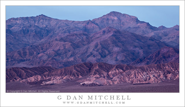
Post-Sunset Glow, Amargosa Range. Death Valley National Park, California. March 29, 2011. © Copyright G Dan Mitchell – all rights reserved.

Post-sunset light from bright red clouds casts a reddish glow on the Amargosa Range, Death Valley Buttes, and the Kit Fox Hills.

I think this might be the second in what I could call the “impossible color” series from my late-March trip to Death Valley. (The previous image was a photograph of a wash/alluvial fan at the base of Tucki Mountain, photographed on the same evening.) The lurid and unreal colors are not the result of post-processing gone horribly wrong – the light was actually this color for a short period. The sun had already gone down behind the Cottonwood Mountains to the west of my shooting location in the middle of Death Valley not far from Stovepipe Wells. It had been an interesting sunset with the usual increase in warm colors and some attractive clouds in the sky.

What happened next was something that is probably familiar to those who have done a lot of landscape photography, though they recognize that it is not something that you can quite predict. After the sun had set and dusk was coming on, some final light from far to the west, where the sun had probably already dropped just below the horizon, began to strike high clouds above Death Valley. (I could sort of see this coming, since I had noticed increasing color in the sky further to the east.) As this happened, these clouds began to glow with an intense red color that was mixed with the normal bluish tones of dusk light and surface features took on this purple/red glow for just a brief moment before the light faded.

(Those who look very carefully may notice that the sky above and to the east of the mountains is a lot bluer than the mountains themselves. The color had already left the sky to the east, and at this point was coming from the sky directly overhead and to my west.)

I’m still trying to sort out the complex geology of this area and the ways that features are named. The larger range containing these peaks is called the Amargosa Range, though it encompasses many smaller named sub-ranges – I think these might be part of the Grapevine Mountains, roughly in the neighborhood of Thimble and Corkscrew Peaks. A dark peak in front of the main range at the very far right may be part of Death Valley Buttes, and the banded foreground hills are sometimes called the “Kit Fox Hills.”

G Dan Mitchell Photography | Flickr | Twitter | Facebook |
LinkedIn | Email
Text, photographs, and other media are © Copyright G Dan Mitchell (or others when indicated) and are not in the public domain and may not be used on websites, blogs, or in other media without advance permission from G Dan Mitchell.