Patterns in eroded shoreline sandstone rocks at the Point Lobos State Reserve, California.
The rugged Point Lobos shoreline in places exposes some very interesting rocks, including sections like this one where layers of different colored sand stone are gradually worn away, revealing underlying layers of different colors and textures and sometimes exposing surprising color contrasts. On days when the light is very soft (or very boring!) I may seek out some of these rocks and photograph them since the softer light lets details appear that might easily be washed out in harsher light.
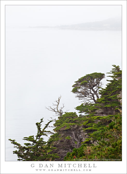
Carmel Peninsula is barely visible though fog beyond Monterey Cypress trees along the north shore of Point Lobos State Reserve.
This was a typical summer day in coastal California – completely socked in by a thick, gray blanket of cold, wet fog! The light was somewhat dismal, so it wasn’t a day for typical “scenic” landscape or seascape photography, though the colors of the plants and trees were saturated by the soft light and the distant peninsula faded almost to monochrome though the fog across the bay.
These Monterey cypress trees grow along the tops of the rocky cliffs above this part of the Pacific Ocean, in some of the most exposed and precipitous locations imaginable. In some spots they are left exposed to the full force of the ocean winds and winter storms, and they grow close to the ground, following the contours of the rocky terrain in ways that remind me of trees growing in exposed locations near timberline in the Sierra. In other spots they are a bit more sheltered and they seem to be able to “stretch out” a bit, as these trees do along a section of the rocky cliffs that faces more into the bay than out to sea.
The bay holds the outlet of the Carmel River, and the peninsula visible across the water in the distance is the coastline of the town of Carmel. The foreground trees are within the boundaries of the Point Lobos State Reserve.
Detail photograph of the patterns of overlapping gullies near Zabriskie Point, Death Valley National Park.
I have been working on a sort of informal project to photograph small details at Zabriskie Point that do not necessarily reveal the larger, familiar, and very iconic landscape of the place. A few years ago I noticed – almost by accident – that certain features of the surrounding landscape can be photographed in conditions quite different from the “standard” dawn and very early morning lighting. In fact, some of the geology can, I think, be photographed in interesting ways even during unusual times of the day when there is full sunlight. A bit later in the morning the light, which tends to glance across the tops of some features earlier in the day, begins to penetrate down into the little valleys and gullies and reflect into them from some of the brighter surfaces. While it can work in full sun, it may work even better when there is a bit of overcast, as there was when I made this photograph and a couple others in the series.
With this specific subject I also tend to work from a bit of a distance using long focal length lenses. This one was shot at 400mm! This poses a problem that we don’t encounter as often when using more (supposedly) typical landscape focal lengths, namely that it is hard to get the whole subject in focus due to depth of field issues that become more apparent with such long lenses.
Also, when photographing these rather pale and pastel formations, it is very easy to succumb to the temptation to jazz things up a bit. To be honest, I have seen some very good and interesting work that relied on amplifying contrast and the subtle colors. However, I’m trying hard to not go too far with this. I certainly do some work in post to balance things out a bit and to get the effect that I think best evokes what I recall of the scene, but I’m avoiding the inclination to, for example, adjust curves to the point that I get a lot of pure blacks and whites in this subject that mostly contains bright mid-tones.
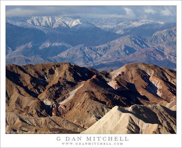
Morning light on fresh snow on the summit of the Panamint Range with Zabriskie Point Badlands in the foreground, Death Valley National Park.
After getting being frustrated by falling snow earlier in the morning when I tried to photograph dawn at Dantes View I headed back down to lower terrain. (Although I was not successful in photographing at Dantes View and, in fact, turned back before the summit in dense clouds and falling snow, it was quite an interesting visit!) I stopped along the way and made some photographs before arriving at Zabriskie Point.
At this point I no longer reflexively photograph at Zabriskie, though I will if something special or unusual is happening with the conditions. Having been frustrated in my original plans, I figured I might as well take a look around since I was there. I left the camera gear in my car and walked up the hill to the famous overlook to see what I could see. The dawn light – if there had even been any on this cloudy morning – was long gone, though a few photographers were still hanging out. As I looked about I noticed two things. First, the clouds were just beginning to thin over the Panamint range. While the summit of Telescope Peak was still socked in – it appeared to be snowing there – light was beginning to break through gaps in the clouds above the east side of the range and interesting shadows were appearing below the snow line. Second, the partially cloudy conditions were softening the light right in the Zabriskie/Gower Gulch area and the light in some of my favorite small gullies to the right of the observation area was looking somewhat interesting. (I have made a project of photographing them with a long lens.)
With no other specific plan, and two potential subjects right here, I followed one of those “laws of photography” that says shoot the thing you see now rather than continuing to wander around hoping that some other miracle crops up. (Sometimes this is great advice. Other times it is dead wrong!) I walked back down the hill to my car, grabbed my gear, and walked back up. I first spent some time photographing the nearby gullies. (I think I have a couple of interesting images of them that will appear here eventually.) But I quickly turned my attention to the interesting weather and light across the Valley, thinking about how I might photograph this wild and rugged scene without making it look like another Zabriskie Point image. I decided to use a relatively long focal length lens – which was already on the camera for shooting the gullies anyway – and try to fill the entire frame with a combination of close and far mountains and snow and clouds in the morning light.
Photographer and visual opportunist. Daily photos since 2005, plus articles, reviews, news, and ideas.
Manage Consent
To provide the best experiences, we use technologies like cookies to store and/or access device information. Consenting to these technologies will allow us to process data such as browsing behavior or unique IDs on this site. Not consenting or withdrawing consent, may adversely affect certain features and functions.
Functional
Always active
The technical storage or access is strictly necessary for the legitimate purpose of enabling the use of a specific service explicitly requested by the subscriber or user, or for the sole purpose of carrying out the transmission of a communication over an electronic communications network.
Preferences
The technical storage or access is necessary for the legitimate purpose of storing preferences that are not requested by the subscriber or user.
Statistics
The technical storage or access that is used exclusively for statistical purposes.The technical storage or access that is used exclusively for anonymous statistical purposes. Without a subpoena, voluntary compliance on the part of your Internet Service Provider, or additional records from a third party, information stored or retrieved for this purpose alone cannot usually be used to identify you.
Marketing
The technical storage or access is required to create user profiles to send advertising, or to track the user on a website or across several websites for similar marketing purposes.