Tag Archives: point

Photographing Death Valley – Part 1

This material concerning Death Valley is unavailable while revisions are underway. Thanks for your understanding. In the meantime, I will respond to comments left on this page.

(Update 3/22/13: The planned update to this article has been long-delayed, and for that I apologize. It turns out that the way I want to approach the subject in the revised version is a bit more complicated than I expected. I had anticipated completing an update in early 2013, but I decided to wait until after this year’s shoot in Death Valley so that I would write with that experience fresh in my mind.)

Also, more (but not all!) of my Death Valley photography is found here: https://gdanmitchell.com/gallery/v/NaturalWorld/TheLandscape/Desert/DeathValley/

(Note: After a conversation with a friend who is a retired Yosemite ranger, in which he articulately explained why he has concerns about sharing overly specific information about sensitive and fragile places too widely, I have decided to revise this article about photographing Death Valley. The goal is to remove some of the unnecessarily specific details about places that don’t need a lot more publicity, and to let photographers who are new this wonderful park learn about it the way I did and continue to do – by slowly exploring and adding to my knowledge and experience of the place rather than looking for a quick list of the “great shots.” I hope you’ll understand.

© Copyright 2013 G Dan Mitchell – all rights reserved.

G Dan Mitchell is a California photographer and visual opportunist whose subjects include the Pacific coast, redwood forests, central California oak/grasslands, the Sierra Nevada, California deserts, urban landscapes, night photography, and more.
Blog | About | Flickr | Twitter | FacebookGoogle+ | 500px.com | LinkedIn | Email

Text, photographs, and other media are © Copyright G Dan Mitchell (or others when indicated) and are not in the public domain and may not be used on websites, blogs, or in other media without advance permission from G Dan Mitchell.

Point Lobos and Beyond

The weather service was reporting very large surf along the Pacific coast today, so I decided to head down towards Point Lobos and do some photography. It seems that I wasn’t the only one! Point Lobos was so packed that there was no parking left, and many cars were parked out on the highway. I changed plans, kept driving south, and ended up shooting along the Big Sur coast instead.

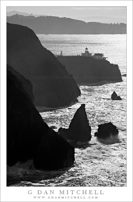
Point Bonita Lighthouse, Marin Headlands

Point Bonita Lighthouse, Marin Headlands

Point Bonita Lighthouse, Marin Headlands. Golden Gate National Recreation Area, California. December 18, 2009. © Copyright G Dan Mitchell – all right reserved.

Black and white photograph of the Point Bonita Lighthouse above the Pacific Ocean surf of the Marin Headlands with the south side of the Golden Gate beyond.

I earlier posted a photograph of the inland side of Point Bonita – this one is from the Pacific Coast side, high on bluffs just north of the Point Bonita Lighthouse and looking south back across the outer entrance to the San Francisco Bay. This is a very rugged bit of coastline here between the Bay and Rodeo Beach and Fort Cronkhite just to the north, where there is a wide beach at the end of a valley.


G Dan Mitchell is a California photographer and visual opportunist. His book, “California’s Fall Color: A Photographer’s Guide to Autumn in the Sierra” is available from Heyday Books and Amazon.

Blog | About | Flickr | FacebookEmail

Links to Articles, Sales and Licensing, my Sierra Nevada Fall Color book, Contact Information.


All media © Copyright G Dan Mitchell and others as indicated. Any use requires advance permission from G Dan Mitchell.

G Dan Mitchell Photography | Twitter | Friendfeed | Facebook | Facebook Fan Page | Email

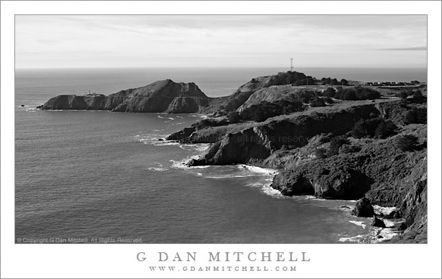
Point Bonita, Pacific Ocean

Point Bonita, Pacific Ocean

Point Bonita, Pacific Ocean. Marin Headlands, California. December 18, 2009. © Copyright G Dan Mitchell – all rights reserved.

Black and white photograph of morning light on coastal cliffs and beaches near the Point Bonita Lighthouse in the Marin Headlands with the Pacific Ocean beyond – Golden Gate National Recreation Area.

This photograph represents another “stop the car, back up, and shoot this now!” moments – the second one during a single weekend.

I had taken a long day to photograph north of San Francisco, ostensibly with the excuse of having to meet someone in the City that evening – heck, might as well leave early and spend the day shooting, right? I had only vague plans to head across the Golden Gate Bridge when I started out that morning, but I stopped near the north end and headed up into the Marin Headlands when I saw some pretty special lighting and atmospheric conditions over the Bay. After shooting that general subject (including photos of the Bridge, the Bay, and the City posted earlier and still to come) I drove on up the road and then out toward Point Bonita.

The last part of this road is a narrow, twisty one-way drive high on the coastal hills above the outer reaches of the Golden Gate. As I came around one turn the view opened up and I saw – for the first time, though I’ve been here before – this great view of Point Bonita and the Pacific. I quickly stopped, set up, and made a few exposures.

The Point Bonita area is an interesting one. All along this section of the Marin Headlands are found old forts and artillery sites, supposedly to protect the Bay from invasion by sea. There is no longer a military presence here – this is now part of the Golden Gate Recreation Area, but many of the historic sites remain. Point Bonita itself is the site of a lighthouse at the north edge of the entrance to San Francisco Bay. It is a wild place. Not only it is in a spectacular location of tall coastal bluffs and steep cliffs that is fully open to the power of the Pacific, but the lighthouse itself is on a small island set slightly apart from the main landmass. The only way to get to it is to walk a trail along the steep cliffs – which passes through a tunnel at one point – then cross the top of the low bluff, and then walk the bridge to the small island.

This photograph is not in the public domain and may not be used on websites, blogs, or in other media without advance permission from G Dan Mitchell.
G Dan Mitchell Photography | Twitter | Friendfeed | Facebook | Facebook Fan Page | Email

keywords: california, usa, travel, scenic, san francisco, bay, area, golden, gate, national, recreation, area, park, stock, marin, county, headlands, point, bonita, fort, historic, beach, coast, shore, pacific, ocean, coastline, waves, surf, horizon, sky, clouds, bluffs, rocks, island, trees, nature, landscape, seascape, tower, antenna, trail, road, travel, scenic, black and white, monochrome, stock, morning, light