Tag Archives: sage

Owens Valley, Tungsten Hills, and Mount Tom

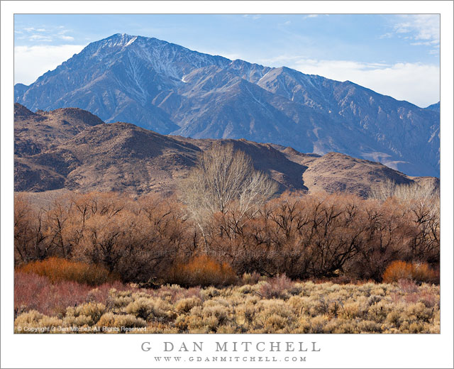
Owens Valley, Tungsten Hills, and Mount Tom - Massive Mount Tom rises above the Tungsten Hills and the high desert terrain of Owens Valley near Bishop, California.
Massive Mount Tom rises above the Tungsten Hills and the high desert terrain of Owens Valley near Bishop, California.

Owens Valley, Tungsten Hills, and Mount Tom. Eastern Sierra Nevada, California. January 2. 2012. © Copyright 2012 G Dan Mitchell – all rights reserved.

Massive Mount Tom rises above the Tungsten Hills and the high desert terrain of Owens Valley near Bishop, California.

When I’m driving to a photography destination, I often have to suppress the desire to stop and make photographs along the way. If I’m not careful, I can end up spending extra hours on the drive and arrive too late. (Sometimes I plan extra time for my long drives just to accommodate my need to stop and photograph en route.) I cope with sighting photographic potential as I drive by either pretending it isn’t there, filing it away for a later trip… or occasionally giving in and stopping.

As I headed down highway 395 on this winter afternoon, on my way to get a camp site in Death Valley, I was aware of the fact that if I took too long I would end up having to find a camp site and set up camp after dark when I arrived – and my destination was still hours away. But after descending to Round Valley just north of Bishop, California I became more aware of the interesting and somewhat unusually afternoon winter light and I finally just had to make a quick stop. The foreground Owens Valley high desert plants had lost all of their “green,” and now had a range of shades of yellow, brown, red, white, black, and even a bit of near-purple. Beyond them the Tungsten Hills began the rise from the valley toward the crest of the eastern escarpment of the Sierra, here dominated by the bulk of massive Mount Tom, a very tall peak that appears even larger because it sits more to the east than most of the other high peaks. The combination of backlight from above the range and high, thin clouds created a sort of muted sunny effect.

G Dan Mitchell is a California photographer whose subjects include the Pacific coast, redwood forests, central California oak/grasslands, the Sierra Nevada, California deserts, urban landscapes, night photography, and more.

Blog | About | Flickr | Twitter | FacebookGoogle+ | 500px.com | LinkedIn | Email

Text, photographs, and other media are © Copyright G Dan Mitchell (or others when indicated) and are not in the public domain and may not be used on websites, blogs, or in other media without advance permission from G Dan Mitchell.

Cook Bank Ruins, Rhyolite

Cook Bank Ruins, Rhyolite - The ruins of the Cook Bank in the ghost town of Rhyolite, Nevada, with barren desert hills under a pre-sunrise sky.
The ruins of the Cook Bank in the ghost town of Rhyolite, Nevada, with barren desert hills under a pre-sunrise sky.

Cook Bank Ruins, Rhyolite. Rhyolite, Nevada. January 3, 2012. © Copyright 2012 G Dan Mitchell – all rights reserved.

The ruins of the Cook Bank in the ghost town of Rhyolite, Nevada, with barren desert hills under a pre-sunrise sky.

This was the closest to the winter solstice that I’ve visited Rhyolite, so I shouldn’t have been surprised by several things. First, the sun came up not only later, but also a bit further south along the horizon – and the light that would usually strike these ruins at sunrise was blocked for a while by a large hill that sits next to the town. Second, it was cold! Third, no one else was there at sunrise! This is a bit unusual since in the Death Valley high season (which arrives a bit later in the year), Rhyolite can be a pretty popular place… for a ghost town… in the middle of the desert… in Nevada. :-)

Because I have photographed here several times before and for the reasons mentioned above, I took a bit of a different approach to photographing the place this time. The winter light, some high clouds, and the different point along the horizon of the sun rise meant that the light was quite different from what I’ve occasionally had to work with in the past. At first I was a bit disappointed to realize that the direct dawn light was not going to strike the old Cook Bank and other nearby buildings. But when some clouds to the east obscured the direct light and high, thin overhead clouds begin to pick up color and fill in the shadows, I saw that other interesting lighting was going to make up for it. At the moment that I made this photograph, those clouds to the east (right) of my position beautifully softened what might otherwise have been some stark and harsh light on the pinnacles beyond the town. They also created an unusual and beautiful quality of light for a few moments – a reddish-pink quality from the light reflected from the clouds but with a few soft quality.

I decided to shoot from a distance with a long lens so as to control the position of the ruins against the background hills, and the longer focal length makes these hills more prominent than they would be if I shot the building with a shorter focal length from a closer position. This also allowed me to more carefully eliminate some distracting elements that invariably appear at old sites like this. (The first times I visited, access to most of the ruins was quite unimpeded. Now fences have been erected around some of them. Part of me regrets the loss of access, but the greater part of me understands that this will allow these buildings to be around longer so that more people will get to see them. I stayed behind the fences.) If you look around on the web a bit, you can find some wonderful old photographs of this town when it was a bustling place with thousands of residents, and when the Cook Bank was a very impressive and modern-for-the-time building.

G Dan Mitchell is a California photographer whose subjects include the Pacific coast, redwood forests, central California oak/grasslands, the Sierra Nevada, California deserts, urban landscapes, night photography, and more.
Blog | About | Flickr | Twitter | FacebookGoogle+ | 500px.com | LinkedIn | Email

Text, photographs, and other media are © Copyright G Dan Mitchell (or others when indicated) and are not in the public domain and may not be used on websites, blogs, or in other media without advance permission from G Dan Mitchell.
Petroglyphs

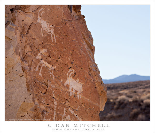
Petroglyphs - Petroglyphs on a rock face overlooking desert terrain
Petroglyphs on a rock face overlooking desert terrain

Petroglyphs. Death Valley National Park, California. January 5, 2012. © Copyright 2012 G Dan Mitchell – all rights reserved.

Petroglyphs on a rock face overlooking desert terrain.

Encountering these very old and very mysterious traces of people who lived in this desert terrain many, many years ago is always a special experience. Perhaps you have read the following story here before, but I think of it every time I encounter these things. Well over a decade ago I was camped in a place in Death Valley National Park that lies somewhere between popular and the anonymous wild spaces far out in the back areas of the park. I was with a group of other people. In the morning I wandered away from the place where we were camped. I crossed a wash and walked up onto the base of a great alluvial fan, found a suitable “sitting rock,” and just sat there for a while taking in the immense space and silence. I happened to look down at the rocky ground and I an oddly shaped rock caught my attention. I’m no expert on these things, but it seemed completely clear to me that this rock had been shaped by human hands. (I later came to understand that it was probably a “knife,” perhaps one designed for scraping.)

At the moment I saw and then picked up and held this rock, the place was transformed from a semi-wilderness of rock and scattered plants into a very different sort of thing – a place that had been the home of people, many years before I sat there on my rock. My thoughts turned from the landscape around me to try to imagine the person who had created and held this rock – who was this person? what was it like to live in such a place in such a time? what had happened to them? I returned the rock to the desert floor and walked back to my camp.

The petroglyphs in the photograph are located in another place in the park, and I have visited and photographed them more than once. These are perhaps the most precious and among the most fragile things in this desert, which is why I never write about the specifics of their locations. (I also have photographs of petroglyphs that have been defiled by thoughtless morons.) If you know where these are, let’s keep it to ourselves, OK?

The first time I photographed these examples of rock art, I simply shot them straight on so that the shapes were as clear and large as possible. Since then I had been thinking of trying to photograph them in a way that might reveal them in the context of the larger surroundings – perhaps as the person or people who made them might have seen the place.

G Dan Mitchell is a California photographer whose subjects include the Pacific coast, redwood forests, central California oak/grasslands, the Sierra Nevada, California deserts, urban landscapes, night photography, and more.
Blog | About | Flickr | Twitter | FacebookGoogle+ | 500px.com | LinkedIn | Email

Text, photographs, and other media are © Copyright G Dan Mitchell (or others when indicated) and are not in the public domain and may not be used on websites, blogs, or in other media without advance permission from G Dan Mitchell.

Frozen Pond and Sierra Nevada Range, Owens Valley

Frozen Pond and Sierra Nevada Range, Owens Valley

Frozen Pond and Sierra Nevada Range, Owens Valley. Long Valley Area, California. October 9, 2011. © Copyright 2011 G Dan Mitchell – all rights reserved.

The snow-dusted eastern escarpment of the Sierra Nevada reflected in the surface of a frozen pond on the high desert of Owens Valley, California.

On a very cold early October morning this year I ended up driving out into Owens Valley toward the Owens River after I spotted some interesting morning fog while driving out of Mammoth Lakes on highway 395. Although I had started out with the intention of photographing aspens, when I saw the fog I changed my plans and decided to leave the aspen photography for later. I first drove to a small lake where I have photographed several times in the past, a lake that provides very still water at sunrise and great reflections of the peaks of the Sierra crest which were covered with the snow from a series of early season storms.

After sunrise I decided that I was finished at that lake, so I got back in the vehicle and went exploring on some gravel roads that wander around in the general area of Hot Creek and Owens River. At first I aimed for some ground fog-covered areas that I had spotted earlier, and for a section of creek where the warm water seems to frequently create interesting fog on cold mornings. I arrived at this creek, took a look around, and decided that it wasn’t quite what I wanted to photograph, so I kept driving, ending up on some roads I had not visited before. As I crossed one long flat area of rangeland I passed this mall frozen pond, drove a bit further, and then turned around to come back and photograph it with the early morning – but no longer dawn – like on the snow-covered peaks just south of Mammoth.

G Dan Mitchell is a California photographer whose subjects include the Pacific coast, redwood forests, central California oak/grasslands, the Sierra Nevada, California deserts, urban landscapes, night photography, and more.
Blog | About | Flickr | Twitter | FacebookGoogle+ | 500px.com | LinkedIn | Email

Text, photographs, and other media are © Copyright G Dan Mitchell (or others when indicated) and are not in the public domain and may not be used on websites, blogs, or in other media without advance permission from G Dan Mitchell.