Tag Archives: winding

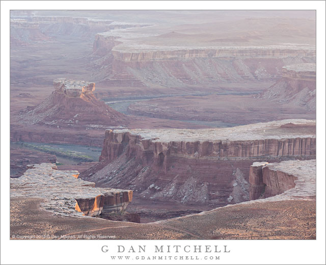
Turk’s Head, Green River, Evening Haze

Turk's Head, Green River, Evening Haze - The Green River curves past Turk's Head in evening haze, Canyonlands National Park, Utah.
The Green River curves past Turk's Head in evening haze, Canyonlands National Park, Utah.

Turk’s Head, Green River, Evening Haze. Canyonlands National Park, Utah. April 6, 2012. © Copyright 2012 G Dan Mitchell – all rights reserved.

The Green River curves past Turk’s Head in evening haze, Canyonlands National Park, Utah.

Just to the west of the “Island in the Sky” area of Canyonlands National Park, the Green River flows though deep and rugged canyons on its way to the confluence with the Colorado River. The river and its tributary streams have cut thousands of feet down through the layers of rock, exposing plateaus and steep canyon walls and more sandstone than can be believed. At Turks’ Head the river winds through a very large S-curve that widens the lower part of the canyon.

I had begun shooting the evening light at the Green River Overlook somewhat earlier on this evening, and by the time I made this photograph the direct light was almost gone – a bit of it is still hitting the cliff faces at lower left and glancing across the tops of nearby flat areas. It was a rather hazy evening, which is part of what attracted me to this spot – I love shooting into or across back-lit haze which can almost glow in the right light and which can also enhance the sense of distance in the scene. Of course, most of the “glow” was gone by this time, and the result is something a lot more subtle with the most distant terrain above the far end of a tributary canyon almost disappearing into the distant haze.

G Dan Mitchell is a California photographer whose subjects include the Pacific coast, redwood forests, central California oak/grasslands, the Sierra Nevada, California deserts, urban landscapes, night photography, and more.
Blog | About | Flickr | Twitter | FacebookGoogle+ | 500px.com | LinkedIn | Email

Text, photographs, and other media are © Copyright G Dan Mitchell (or others when indicated) and are not in the public domain and may not be used on websites, blogs, or in other media without advance permission from G Dan Mitchell.

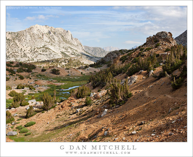
East Side of Bishop Pass

East Side of Bishop Pass - Trail and meadows below the east side of Bishop Pass, eastern Sierra Nevada range
Trail and meadows below the east side of Bishop Pass, eastern Sierra Nevada range

East Side of Bishop Pass. Eastern Sierra Nevada, California. August 4, 2005. © Copyright 2005 G Dan Mitchell – all rights reserved.

Trail and meadows below the east side of Bishop Pass, eastern Sierra Nevada range.

This photograph comes from about a dozen years ago. I recently came across it while sorting through older photograph files for a variety of reasons – general clearing out of old images, searching for photographs of a particular subject for a client, and seeing what older images I might have missed when I first made them. When I saw this photograph it evoked a whole series of fun recollections.

Nearly weeks earlier, I had begun a two-week-long backpack trip along a section of the John Muir Trail. At that time, the only section of the JMT that I had not hiked (at least once!) was an area between approximately Shadow Lake and the Muir Trail Ranch – and this was to be the trip on which I covered this remaining bit of trail. The trip started just fine, though in some territory that is not exactly my favorite portion of the range – the low areas around Devils Postpile. After passing by that national monument we headed south, passing Duck Lake and camping at Purple Lake.

The next morning I woke up feeling a bit under the weather, an unusual experience for me on the trail. The next leg of the trip was to take us through an area without an easy exit, and I became concerned about what would happen if my “feeling poorly” deteriorated into actually being sick. I reluctantly decided to leave my group to continue without me, and I backtracked over Duck Pass and down into the Mammoth Lakes area and headed home. (Ironically, by the time I got out I was feeling fine…)

Ending a trip this way just didn’t feel right, so I hatched a plan to show up and run into my friends on the last day of their trip. Since they were coming out over Bishop Pass, I crossed that pass into beautiful Dusy Basin a day earlier, and on the next morning hiked down the canyon so that I could be casually sitting on a rock as they came up the trail from LeConte Canyon. I have rarely seen people as surprised as they were when they found me! After our reunion and joining them for their last trail night, the next morning we were up early to hike out over Bishop Pass. This photograph was made shortly after we crossed the pass and began our descent to the trailhead.

G Dan Mitchell is a California photographer whose subjects include the Pacific coast, redwood forests, central California oak/grasslands, the Sierra Nevada, California deserts, urban landscapes, night photography, and more.
Blog | About | Flickr | Twitter | FacebookGoogle+ | 500px.com | LinkedIn | Email

Text, photographs, and other media are © Copyright G Dan Mitchell (or others when indicated) and are not in the public domain and may not be used on websites, blogs, or in other media without advance permission from G Dan Mitchell.
Ranch and Morning Fog, Owens Valley

Ranch and Morning Fog, Owens Valley

Ranch and Morning Fog, Owens Valley. Owens Valley, California. October 9, 2011. © Copyright 2011 G Dan Mitchell – all rights reserved.

As is often the case, there is a story behind this photograph – an image that I think is fairly atypical of my work, at least as to the subject.

A year ago, almost to the day, I was also in the eastern Sierra to photograph aspens. And on that day I got up very early at my lodging in Mammoth and headed out before sunrise, which it was still dark actually, without a fixed idea of where or what I was going to photograph. I reached highway 395 and headed south, with a vague idea of heading up one of the promising canyons such as that of McGee or perhaps Rock Creek. But very soon I saw fog out in Owens Valley above Crowley Lake and I started thinking of instead heading away from the Sierra and out into that Valley. I ended up at a small pond from which I photographed the light from the rising sun as it hit the eastern slopes of the Sierra.

That show was over fairly quickly, so I decided to explore a bit. I had noticed mist and fog in various places in the surrounding area. Some of it seemed to come from small hot springs while in other places it seemed to extensive for that. I picked, more or less randomly, some gravel roads that headed toward the foggy areas and ended up on Hot Creek, where I made several photographs of and through the fog rising from the water.

Fast forward to this year. The first day of aspen shooting was productive, but the colors were overall not really as spectacular as I had hoped. If the intended subject “isn’t happening,” I’ll often change course and look for something else. So, once again I woke up without an aspen photography plan, but with two other vague ideas in mind. One was to go up to Minaret Summit and photograph the first light on the Minarets and Ritter and Banner Peaks. The other was to drive south again on 395 to see what would happen. When I got in my car to head out I still literally did not know where I would go. I sat in the car a moment and then, for reasons that I can’t recall, picked the 395 option. (Later I realized that the other option could have been productive, too.) I headed south on 395 and was astonished to see – again! – the fog over Crowley and the mist rising out in Owens Valley. So I went to my little lake to shoot there first and then headed out to where I had shot Hot Creek last year, but this time I kept going. At one point I passed this small range while heading out but couldn’t see a shot. Later on my return trip I passed it again, and this time I saw the stock grazing in the frozen meadow next to this small creek, with mist and fog rising everywhere. I stopped.

(By the way, this is a color photograph…)

G Dan Mitchell Photography
About | Flickr | Twitter | FacebookGoogle+ | 500px.com | LinkedIn | Email

Text, photographs, and other media are © Copyright G Dan Mitchell (or others when indicated) and are not in the public domain and may not be used on websites, blogs, or in other media without advance permission from G Dan Mitchell.

(Basic EXIF data may be available by “mousing over” large images in posts when this page is viewed on the web. Leave a comment if you want to know more.)

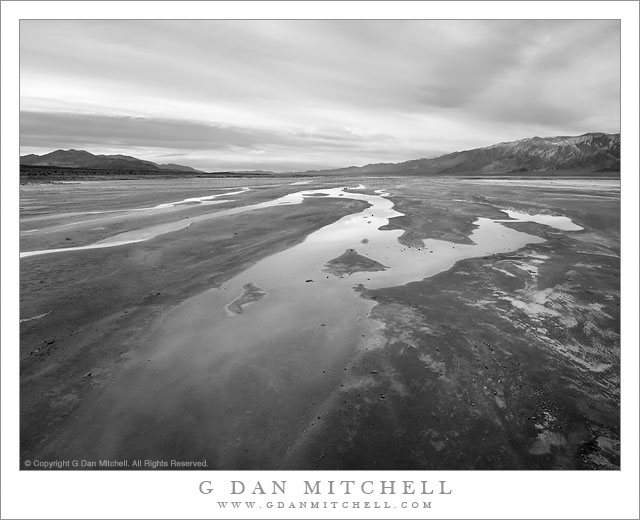
Morning Sky Reflected in Desert Stream

Morning Sky Reflected in Desert Stream

Morning Sky Reflected in Desert Stream. Death Valley National Park, California. February 21, 2011. © Copyright G Dan Mitchell – all rights reserved.

Black and white photograph of water from a salt spring reflecting cloudy morning sky above Death Valley.

Moments before I made this stark and, I think, desolate photograph of the shallow stream from a salt spring flowing slowly over the flats of Death Valley and reflecting the light from morning clouds, the Panamint Range mountains at the left side of the frame had been briefly lit by colorful sunrise light. But this light lasted only a couple minutes and shortly everything went largely gray.

The patterns of the very shallow and slowly flowing water as they spread out across the flats and reflected the light from the cloud filled sky intrigued me as soon as I arrived at this location. But before I made this photograph I had taken a different approach, positioning the camera down very low and very close to the water so that its reflective surface filled a larger portion of the frame and then lining things up to catch the first light on the Panamints and its reflection. But when that passed so quickly, it seemed like the flat and gray effect could also make an interesting photograph. When I made the exposure I wasn’t quite certain, but I think I was leaning towards a black and white rendition of the scene. Frankly, there wasn’t a lot of color to work with! The sky was mostly clouded over, though there was a hint of faded blue in a few spots. Any color in the Panamints was muted by the distance and haze. The mud is essentially gray and white (where salt has formed) and the water held less color than the sky!

G Dan Mitchell Photography | Flickr | Twitter | Facebook | Email
Text, photographs, and other media are © Copyright G Dan Mitchell (or others when indicated) and are not in the public domain and may not be used on websites, blogs, or in other media without advance permission from G Dan Mitchell.