Tag Archives: amargosa

Post-Sunset Glow, Amargosa Range

Post-Sunset Glow, Amargosa Range

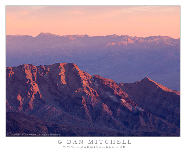
Post-Sunset Glow, Amargosa Range. Death Valley National Park, California. March 29, 2011. © Copyright G Dan Mitchell – all rights reserved.

Post-sunset light from bright red clouds casts a reddish glow on the Amargosa Range, Death Valley Buttes, and the Kit Fox Hills.

I think this might be the second in what I could call the “impossible color” series from my late-March trip to Death Valley. (The previous image was a photograph of a wash/alluvial fan at the base of Tucki Mountain, photographed on the same evening.) The lurid and unreal colors are not the result of post-processing gone horribly wrong – the light was actually this color for a short period. The sun had already gone down behind the Cottonwood Mountains to the west of my shooting location in the middle of Death Valley not far from Stovepipe Wells. It had been an interesting sunset with the usual increase in warm colors and some attractive clouds in the sky.

What happened next was something that is probably familiar to those who have done a lot of landscape photography, though they recognize that it is not something that you can quite predict. After the sun had set and dusk was coming on, some final light from far to the west, where the sun had probably already dropped just below the horizon, began to strike high clouds above Death Valley. (I could sort of see this coming, since I had noticed increasing color in the sky further to the east.) As this happened, these clouds began to glow with an intense red color that was mixed with the normal bluish tones of dusk light and surface features took on this purple/red glow for just a brief moment before the light faded.

(Those who look very carefully may notice that the sky above and to the east of the mountains is a lot bluer than the mountains themselves. The color had already left the sky to the east, and at this point was coming from the sky directly overhead and to my west.)

I’m still trying to sort out the complex geology of this area and the ways that features are named. The larger range containing these peaks is called the Amargosa Range, though it encompasses many smaller named sub-ranges – I think these might be part of the Grapevine Mountains, roughly in the neighborhood of Thimble and Corkscrew Peaks. A dark peak in front of the main range at the very far right may be part of Death Valley Buttes, and the banded foreground hills are sometimes called the “Kit Fox Hills.”

G Dan Mitchell Photography | Flickr | Twitter | Facebook |
LinkedIn | Email
Text, photographs, and other media are © Copyright G Dan Mitchell (or others when indicated) and are not in the public domain and may not be used on websites, blogs, or in other media without advance permission from G Dan Mitchell.

Dusk Clouds, Badwater Basin Salt Flats

Dusk Clouds, Badwater Basin Salt Flats

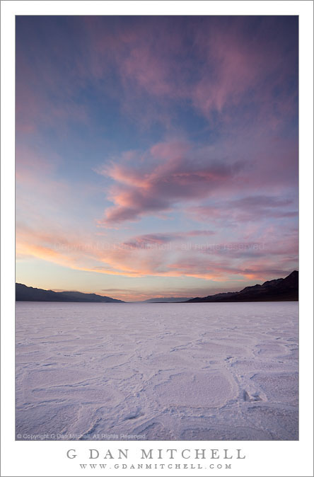
Dusk Clouds, Badwater Basin Salt Flats. Death Valley National Park, California. March 29, 2010. © Copyright G Dan Mitchell – all rights reserved.

Late light illuminates dusk clouds above the salt flats of Badwater Basin, Death Valley National Park, California.

First, my disclaimer: I really am getting very near the end of the photographs of Badwater Basin shot on this late March evening. Really, I am. I’ve posted a number already, but I don’t see how there could be possibly be more than two additional images at this point. :-)

To recap, for anyone who didn’t catch the earlier posts, I visited this spot near Badwater Basin on an evening that turned out to have a wonderful combination of somewhat unusual salt flat conditions and interesting evening clouds. The “unusual conditions” were due to recent heavy rains in Death Valley that had flooded this section of the the salt flats a few weeks earlier. The flooding had subsided – at this point there was some water below the salt crust but the surface was mostly dry – but the character of the salt “polygons” had been “reset to zero” by the water. What had been very jagged and worn and cracked material had been flattened and smoothed. While the joints between the sections of the salt are clearly still visible, they were almost flush with the surface of the flat at this time.

On top of this somewhat rare condition, I was very fortunate to be there on an evening when there were clouds and, in addition, the cloud conditions evolved beautifully as the evening progressed. I saw this possibility earlier in the afternoon, which was one reason that I chose to shoot here, but you can never really know for sure what will happen… until it happens. The clouds started out thicker than what is seen in this photograph but as the day came to an end they began to thin and separate – enough that the colorful light from the evening sun began to light the clouds during the last moments of the day.

This photograph is not in the public domain and may not be used on websites, blogs, or in other media without advance permission from G Dan Mitchell.
G Dan Mitchell Photography | Twitter | Friendfeed | Facebook | Facebook Fan Page | Email

Technical Data:
Canon EOS 5D Mark II
Canon EF 17-40mm f/4 L USM at 17mm
ISO 100, f/16, composite of two photographs at .4 and .8 second exposure time

keywords: late, evening, sunset, dusk, clouds, sky, light, orange, blue, pink, badwater, basin, salt, flat, polygon, white, death valley, national, park, california, usa, north america, landscape, nature, scenic, travel, mountain, amargosa, panamint, range, horizon, stock

Dusk Clouds, Badwater Basin Panorama

Dusk Clouds, Badwater Basin Panorama

Dusk Clouds, Badwater Basin Panorama. Death Valley National Park, California. March 29, 2010. © Copyright G Dan Mitchell – all rights reserved.

Colorful dusk clouds against darkening sky above the salt flats of Badwater Basin and the distant ridges of the Amargosa and Panamint mountain ranges.

This was one of the final photographs I made in fading light on this evening. (I made another series a few minutes later when the sky and clouds and salt flats were all various stages of blue – I may ultimately post that image here as well.) The very last light was catching the clouds above Badwater and the central portions of Death Valley, and the color was already fading quickly in the darker area to the east over the Amargosa Range.

As I have mentioned before, the very wide dynamic range between the shaded surface of the salt flats and the bright bit of sunlit cloud and sky at the far left necessitated the use of two exposures which were then combined in post. (Even after this light finally faded I was not yet finished for the day. An hour or so later I was doing night photography under the light of the rising full moon at Zabriskie Point.)

This photograph is not in the public domain and may not be used on websites, blogs, or in other media without advance permission from G Dan Mitchell.
G Dan Mitchell Photography | Twitter | Friendfeed | Facebook | Facebook Fan Page | Email

Technical Data:
Canon EOS 5D Mark II
Canon EF 17-40mm f/4 L USM at 17mm
ISO 100, f/16, composite of two exposures in the 1/2 to 1/4 second range.

keywords: badwater, basin, salt, flat, polygon, pattern, white, texture, panorama, evening, sunset, twilight, dusk, dark, sky, color, orange, pink, blue, amargosa, panamint, mountain, range, ridge, horizon, death valley, national, park, california, usa, north america, landscape, travel, scenic, nature, stock

Eroded Terrain Near Natural Bridge Canyon

Eroded Terrain Near Natural Bridge Canyon


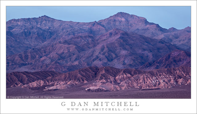
Eroded Terrain Near Natural Bridge Canyon. Death Valley National Park, California. March 27, 2010. © Copyright G Dan Mitchell – all rights reserved.

Rugged and eroded terrain near the entrance to Natural Bridge Canyon in morning light at Death Valley National Park, California.

Natural Bridge Canyon is located at the foot of the Amargosa Range Black Hills just a short distance north of the popular Badwater area. As is typical of many of the canyon entrances in Death Valley, the approach is by leaving the main road paralleling the edge of the Valley and driving up a large alluvial fan on a gravel road towards the hills. The road ends and the canyon quickly narrows.

This photograph was made along this gravel approach road and shows a bit of the fan in the foreground, the cliffs alongside the was in the middle distance, and beyond that the convoluted and colorful strata of the lower section of the mountain range, here with low-angle back light from the morning sun coming from the other side of the mountains. This photograph also shows something that I found remarkable on this visit, namely the incredible profusion of plant life that was coming to live in the wake of some unusually heavy rain fall earlier in the season. During normal years and during most of the year even in wet years you’ll see almost no green at all on terrain like this aside from a few small and isolated bushes. But on this late-March visit there was plant life springing up everywhere. When I looked closely I could find a fringe of green almost everywhere. Here, not only is there obvious growth in the gravel of the wash at the bottom of the frame, but there is a fringe of green along the edges of the cliff and even in the far distance on the higher slopes.

This photograph is not in the public domain and may not be used on websites, blogs, or in other media without advance permission from G Dan Mitchell.

G Dan Mitchell Photography | Twitter | Friendfeed | Facebook | Facebook Fan Page | Email

Technical Data:
Canon EOS 5D Mark II
Canon EF 24-105mm f/4 L IS USM at 73mm
ISO 200, f/13, 1/40 second

keywords: death valley, national, park, california, usa, north america, scenic, travel, nature, desert, rugged, erosion, eroded, mountains, hill, cliff, gully, wash, pink, strata, layer, green, plant, growth, spring, rock, morning, light, natural, bridge, canyon, landscape, nature, stock, plants, rock, gravel, red, black, amargosa