Tag Archives: black and white

Sandstorm, Dunes

Sandstorm, Dunes
Sandstorm, Dunes

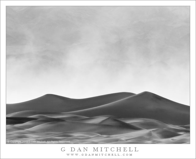
Sandstorm, Dunes. Death Valley National Park, California. April 4, 2013. © Copyright 2013 G Dan Mitchell – all rights reserved.

Strong winds lift clouds of sand high into the air above desert sand dunes, Death Valley National Park.

Sandstorms are common in Death Valley, especially when I visit, typically in the spring. I wasn’t totally surprised (nor totally pleased!) when one arose on the second day of this early April visit. After photographing all morning, I was back in camp to get something to eat and take care of camp business before heading back out in the mid-afternoon for the second shoot of the day. As I sat by my camp I saw a few pillars of dust out in the valley near dunes, and at that point I had a pretty good idea of what might be in store for me in the next few hours. It wasn’t long before the wind began to pick up, soon becoming strong enough to stir up a lot of dust and blow down any weak tents left by campers who had headed out for daytime activities elsewhere.

In objective terms, a sandstorm is an unpleasant thing. It is hot. It is dry. It is full of blowing sand and dust, and the fine dust gets into everything, no matter what you do to try to protect against it. In the worst cases, the blowing sand can damage the paint on vehicles. However, in visual terms, a sandstorm can be quite interesting – as long as you can find ways to shoot it that don’t risk destroying your photographic gear. It looked to me like the main storm was in the middle of the valley, so I figured I might be able to cross the valley, take road along the other side, and skirt the far edge of the storm, and photograph back into it with the light coming from behind. I drove across the valley and stopped right at the edge of the blowing sand and mostly shot from inside my vehicle so as to minimize the dust contamination. From this vantage point I could use a long lens to photograph the abstract shapes of sand dunes, backed by clouds of whirling and drifting sand that obscured the Cottonwood Mountains on the far side of the valley.

G Dan Mitchell is a California photographer and visual opportunist whose subjects include the Pacific coast, redwood forests, central California oak/grasslands, the Sierra Nevada, California deserts, urban landscapes, night photography, and more.
Blog | About | Flickr | Twitter | FacebookGoogle+ | 500px.com | LinkedIn | Email

Text, photographs, and other media are © Copyright G Dan Mitchell (or others when indicated) and are not in the public domain and may not be used on websites, blogs, or in other media without advance permission from G Dan Mitchell.

Rat Rock Island, Hills

Rat Rock Island, Hills

Rat Rock Island, Hills. China Camp, California. January 6, 2013. © Copyright 2013 G Dan Mitchell – all rights reserved.

Rat Rock Island and hills of the north San Francisco Bay

This remarkable little island sits just a short distance from the shoreline along the northern San Francisco Bay. Several things contribute to its visual appeal. It is unexpected, in that it is not exactly common to find such islands in this bay. It seems that what formed the island might have been a process similar to one found in coastal areas with much rougher seas, where rocky peninsulas are eventually cut off from the shoreline. The area is very quiet, in contrast to the busy north bay areas you typically might drive through to get here, and the main sounds are those of shore birds. The view beyond the island is expansive – the far side of the bay is distant enough that you the hills are little more than a think break along the horizon, and mostly you see sky and water. The shape of the island is almost but not quite symmetrical, and the little bonsai-like trees on the “summit” echo the curve of the island.

I used a nine-stop neutral density filter so that I could get a relatively long ten second exposure for this photograph. The idea was to let the slight motion of the water blur and create a smooth, glassy quality. (If the clouds had been moving faster, they might also have been blurred. Although it probably isn’t apparent in the photograph, this image is partially the result of quite a bit of work during the post-processing phase.

G Dan Mitchell is a California photographer and visual opportunist whose subjects include the Pacific coast, redwood forests, central California oak/grasslands, the Sierra Nevada, California deserts, urban landscapes, night photography, and more.
Blog | About | Flickr | Twitter | FacebookGoogle+ | 500px.com | LinkedIn | Email

Text, photographs, and other media are © Copyright G Dan Mitchell (or others when indicated) and are not in the public domain and may not be used on websites, blogs, or in other media without advance permission from G Dan Mitchell.

Sea Stacks and Coastal Bluffs, Northern California

Sea Stacks and Coastal Bluffs, Northern California - Haze obscures sea stacks and bluffs along the rugged Pacific Ocean coastline of Northern California
Haze obscures sea stacks and bluffs along the rugged Pacific Ocean coastline of Northern California

Sea Stacks and Coastal Bluffs, Northern California. Mendocino Coast, California. October 30, 2011. © Copyright 2012 G Dan Mitchell – all rights reserved.

Haze obscures sea stacks and bluffs along the rugged Pacific Ocean coastline of Northern California.

I made this photograph almost a year ago, from just about the same location as a more recent photograph of this scene that I posted a month or so ago. The location is along the Mendocino County coastline of northern California, a rugged and beautiful section of the state. Here the coast highway travels very close to the water along high bluffs that overlook the Pacific, and this particular cove holds this two-peaked island or sea stack and is backed by receding coastal bluffs that extend out into the water. In the far distance the shoreline to the south curves gently back towards the west, creating a large and very shallow bay.

The personality of this land and seascape changes constantly. On a (rare) completely clear day, the view to the farther shoreline might be easier to make out, but on the many foggy days the foreground scene could well be completely obscured. On this morning, most of the fog had cleared back from the coast, leaving a softly hazy atmosphere that amplified the effects of distance, and the surf was creating low clouds of spray along the coastline.

G Dan Mitchell is a California photographer whose subjects include the Pacific coast, redwood forests, central California oak/grasslands, the Sierra Nevada, California deserts, urban landscapes, night photography, and more.
Blog | About | Flickr | Twitter | FacebookGoogle+ | 500px.com | LinkedIn | Email

Text, photographs, and other media are © Copyright G Dan Mitchell (or others when indicated) and are not in the public domain and may not be used on websites, blogs, or in other media without advance permission from G Dan Mitchell.

Tuolumne Meadows, Lembert Dome, and Mount Dana

Tuolumne Meadows, Lembert Dome, and Mount Dana - Lembert Dome and the more distant Mount Dana rise above Tuolumne Meadows, Yosemite National Park
Lembert Dome and the more distant Mount Dana rise above Tuolumne Meadows, Yosemite National Park

Tuolumne Meadows, Lembert Dome, and Mount Dana. Yosemite National Park, California. September 13, 2012. © Copyright 2012 G Dan Mitchell – all rights reserved.

Lembert Dome and the more distant Mount Dana rise above Tuolumne Meadows, Yosemite National Park

This photograph is from my mid-September trip to the Sierra – I spent the first couple of days camped at Tuolumne Meadows before heading over to the “east side” to meet friends for a short pack trip up into McGee Canyon. The photograph was made from what might be described as the central meadow, shooting across a bend in the Tuolumne River, over a band of forest trees, with first Lembert Dome and then Mount Dana rising beyond. Lembert is the well-known dome that towers above the east end of the meadow, and there is a popular trail to the panoramic views at its summit. Mount Dana is the second-tallest peak in the park, being less than 100 feet shorter than Mt. Lyell. Dana sits on the eastern boundary of the park, along the Sierra crest right above Tioga Pass.

Although it was not longer early (at least by my standards) morning when I made this photograph, the typical early morning haze was still present. At this time of year it is a combination of the campfires at Tuolumne Meadows (a relatively small contributor on this morning), typical late season wild-fire smoke, and a bit of natural atmospheric haze. When backlit, this haze can almost glow, and while it does mute the contrast and details on more distant subjects, it also can accentuate the sense of distance through atmospheric recession. I chose to go with a black and white rendition of this scene for several reasons. One, frankly, is just because I felt like it! But on top of that, I like the way that monochrome can perhaps abstract the shapes and lines of the scene a bit more. And in this case, I ended up feeling that shades of gray might be more effective than the particular not-very-exciting color combinations in the scene!

G Dan Mitchell is a California photographer whose subjects include the Pacific coast, redwood forests, central California oak/grasslands, the Sierra Nevada, California deserts, urban landscapes, night photography, and more.
Blog | About | Flickr | Twitter | FacebookGoogle+ | 500px.com | LinkedIn | Email

Text, photographs, and other media are © Copyright G Dan Mitchell (or others when indicated) and are not in the public domain and may not be used on websites, blogs, or in other media without advance permission from G Dan Mitchell.