Tag Archives: boulder

Greenstone Lake, Morning

Greenstone Lake, Morning

Greenstone Lake, Morning. Sierra Nevada, California. August 11, 2011. © Copyright 2011 G Dan Mitchell – all rights reserved.

Early morning light on Greenstone Lake and surrounding trees and rocky terrain.

Greenstone is a relatively small lake just beyond the upper end of Saddlebag Lake, which is itself located just east of the Sierra crest and Yosemite National Park in an area dominated by Mount Conness and the tall ridge on which it stands. I had arrived before dawn at the Saddlebag Lake parking lot so that I could be on the trail before sunrise. Rather than giving in to the temptation to pay for a “water taxi” ride to the other end of the lake, I took the trail along the left shore, and arrived at Greenstone Lake just about the time that the first direct light was making its way down to this lake and the surrounding rocky hillside.

In this wet year with its late arrival of summer conditions, everything was still very wet around the lake and the meadow plants were still green and growing. (In dry years they start to finish up their growth spurt and begin turning brown by this time.)

I think this lake is a bit tricky to photograph in morning light. The light could be lovely at sunrise, but it would still be well up on the high ridges above the lake. It takes a long time for the sun to get high enough to rise above the ridge leading to Tioga Peak, and by that time most of the early morning warm light quality has given way to more typical daytime light. There were a few challenges in this photograph. They included trying to figure out how to find a workable composition in such a complex scene that was made even more complex by the reflections in the water. I think the triangle of rocky terrain in the upper half of the frame may help with this. The light posed several problems, mainly related to the very large dynamic range between the bright rocks and the shaded areas of forest at upper right. The light color was also tricky – because the shadows tend to be much bluer in a photograph than your eyes register when you are there, I had to mute the very blue quality of the shadows. This was done partly with an overall adjustment to color, but some additional work had to be done directly on the shadows.

G Dan Mitchell Photography
About | Flickr | Twitter | FacebookGoogle+ | 500px.com | LinkedIn | Email

Text, photographs, and other media are © Copyright G Dan Mitchell (or others when indicated) and are not in the public domain and may not be used on websites, blogs, or in other media without advance permission from G Dan Mitchell.

(Basic EXIF data may be available by “mousing over” large images in posts. Leave a comment if you want to know more.)

Flooded Meadow Near Greenstone Lake

Flooded Meadow Near Greenstone Lake

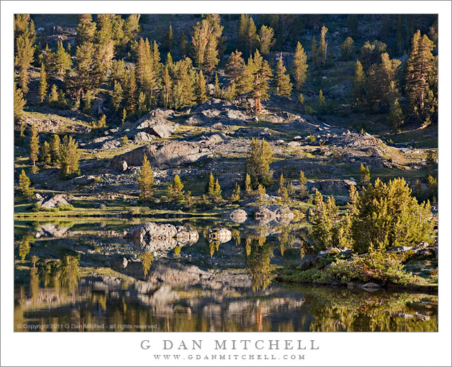
Flooded Meadow Near Greenstone Lake. Sierra Nevada, California. August 11, 2011. © Copyright 2011 G Dan Mitchell – all rights reserved.

Late-season snow fields are reflected in the pond of a flooded alpine meadow near Greenstone Lake, Sierra Nevada.

During this year of heavy and late winter snowfall, there is still a surprising amount of snow in the Sierra Nevada high country. In the upper portion of this image you can see large snow fields (with much larger ones higher on the slope and out of the frame) at that base of this talus slope at around 10,000+ feet of elevation. During a more typical year, there would still be a few scattered snow fields, but nothing like we see this year. And because there is still so much snow, the plants that would normally be well-developed by now are still just emerging, and the creeks and ponds are overflowing, the meadows are flooded… and the mosquitos are having a field day!

This little pond among the boulder-filled meadows near Greenstone Lake at the far end of Saddlebag Lake was still overflowing with snowmelt water that reflected the extensive snow fields still on the talus field beyond. To get to this spot – in mid-August! – I had to cross a number of still frozen snow fields, follow trails that were flooded in places, and pick my way carefully across waterlogged meadows. It is going to be a short summer season in the high Sierra, but as a compensatory bonus we may still see wildflowers all the way into September.

G Dan Mitchell Photography
About | Flickr | Twitter | FacebookGoogle+ | 500px.com | LinkedIn | Email

Text, photographs, and other media are © Copyright G Dan Mitchell (or others when indicated) and are not in the public domain and may not be used on websites, blogs, or in other media without advance permission from G Dan Mitchell.

(Basic EXIF data may be available by “mousing over” large images in posts. Leave a comment if you want to know more.)

Eastern Sierra Nevada Near June Lake

Eastern Sierra Nevada Near June Lake

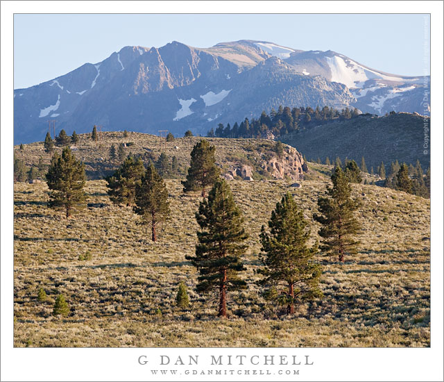
Eastern Sierra Nevada Near June Lake. Mono County, California. August 10, 2011. © Copyright 2011 G Dan Mitchell – all rights reserved.

Trees ascend sage-covered hills toward the Sierra Nevada crest near June Lake, California.

Near highway 395 in Mono County, the main north-south route east of the Sierra crest, these open stands of large conifers ascend from the high desert sagebrush country towards the peaks of the Sierra crest, which rise much more abruptly on this side of the range than on the gentle west side. The tall ridge is above the June Lakes resort area between Mammoth Lakes and Lee Vining.

While my primary goal on this trip was to photograph in the Yosemite high country along Tioga Pass Road, smoke from a wildfire near Glacier Point in the park was drifting over the Tuolumne area and creating a lot of very non-photogenic haze. I had a hunch that by dropped over to the east side of the range I might be able to get away from the smoke or at least find areas where it wasn’t so thick. The smoke was still affecting the light near Lee Vining, but I didn’t have to drive too far south to get out of its path, though even here there is a bit of haze increasing the effect of atmospheric recession.

G Dan Mitchell Photography
About | Flickr | Twitter | FacebookGoogle+ | 500px.com | LinkedIn | Email

Text, photographs, and other media are © Copyright G Dan Mitchell (or others when indicated) and are not in the public domain and may not be used on websites, blogs, or in other media without advance permission from G Dan Mitchell.

(Basic EXIF data may be available by “mousing over” large images in posts. Leave a comment if you want to know more.)
Sunset and Moonrise, Kuna Crest

Sunset and Moonrise, Kuna Crest

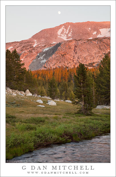
Sunset and Moonrise, Kuna Crest. Yosemite National Park, California. August 10, 2010. © Copyright 2011 G Dan Mitchell – all rights reserved.

The nearly- full moon rises above the sunset light on Kuna Crest, Yosemite National Park.

Kuna Crest runs up Lyell Canyon between the Lyell and Dana forks of the Tuolumne River with the Sierra crest at one end and Mammoth Peak at the other. (Mammoth Peak is the large peak straight in front of you as you top Tioga Pass entering Yosemite National Park.) This ridge can catch great sunset light during the summer, and as I came down from the pass, heading back toward my camp at Porcupine Flat, and saw the almost full moon appearing over the shoulder of the ridge I decided to quickly stop and make a few exposures as the last light was about to leave the forest and soon after the peaks.

If you have tried photographing a scene that includes the moon in the early evening you know that the exposure is a tricky thing. The moon is lit by daylight, so it isn’t too surprising that the “correct” exposure for the moon is close to a normal daytime exposure. But that is not the right exposure for the rest of the scene, which turns out to be quite a bit darker than daylight at this time of day. In this scene things were even more complicates as the very saturated red colors on the ridge were quite “hot,” while the foreground meadow and forest was in shade and both darker and cooler in color. Basically, the dynamic range between the moon and the foreground was too large for a single exposure… so I made several.

At the time of exposure I thought that I might need as many as three component images in the final photograph – they would be one exposed for the bright ridge and sky, one exposed for the rather dark and shadowed foreground, and possibly a third that correctly exposed the moon. To be on the safe side I bracketed four exposures. When I began to work on the image I figured out that in this case I could construct a final “believable” image from two exposures if I was careful and could make some additional adjustments during post.

This is an example of a shot in which the use of a graduated neutral density filter could have been problematic, but where exposure blending could work very well. (“Exposure blending” is one term for the process of manually combining two component exposures using masked layers in Photoshop. No, it is not the same thing as HDR photography.) One of the things that would have been quite tricking using graduated neutral density filters is that the division between the brighter upper half and the darker lower half is not linear. Instead, the roughly follows the curved boundary between the lower meadow and dark trees and the still sunlit trees and the peak and sky.

G Dan Mitchell Photography
About | Flickr | Twitter | FacebookGoogle+ | 500px.com | LinkedIn | Email

Text, photographs, and other media are © Copyright G Dan Mitchell (or others when indicated) and are not in the public domain and may not be used on websites, blogs, or in other media without advance permission from G Dan Mitchell.

(Basic EXIF data may be available by “mousing over” large images in posts. Leave a comment if you want to know more.)