Tag Archives: boulders

Trees and Boulders, Artist Point

Trees and Boulders, Artist Point

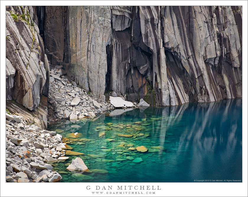
Trees and Boulders, Artist Point. Mt. Baker-Snoqualmie National Forest, Washington. August 28, 2010. © Copyright G Dan Mitchell – all rights reserved.

Ridgetop trees and boulders along the trail catch the afternoon light at Artist Point, Mt. Baker-Snoqualmie National Forest, Washington.

I had been admiring this steep, rugged, and distant ridge all afternoon, starting with our first shooting location down lower on the mountain. As we hiked up the Artist Point trail, we took a detour to the right and I noticed this low rocky ridge covered with trees and the ridge in the distance. At first I couldn’t quite see a shot and I looked elsewhere, but soon I came back to this spot and thought that something with the foreground rocks and trees along with the clouds and more distant ridge might be interesting – but as soon as I saw this a large cloud floated over and blocked the sun from my position, leaving the nearby trees and rocks in shade!

Sometimes when this happens it makes more sense to move on and look for a photograph that works with the conditions you have, but other times it can be worth waiting. It is hard to know for sure which is right, but I decided to set up and sit tight, waiting to see if the light would improve. The light shining around the edge of the cloud was tantalizingly close, but the cloud was stubborn about moving. At one point the light increased a bit for perhaps 15-20 seconds, but then quickly went away. I continued to wait. Finally, the light began to gradually increase, and I got about one minute or less of sun before the cloud again blocked the light – but this was long enough to make a few exposures of this scene.

I have a favor to ask of anyone who is familiar with this area – help in identifying the trees and, even more, help in identifying/naming the distant ridge and the peaks that sit on it. I’m not great at plant identification, but I’m really out of my league in the Cascades. One person walking by as I made the shot seemed to think that the trees are mountain hemlock – but I’d be grateful if anyone can confirm this… or set me straight. Although I was impressed with the peaks on the ridge in the distance in this photograph… I do not have any Washington topographical maps or guide books, so I’m completely in the dark about what to call this ridge or the peaks. Here, too, I would be grateful if anyone can help me identify the ridge, the peaks, and any other important features in the photograph.

Update: A Facebook reader shared information about the peaks on the distant ridge in this photograph…

Alan Majchrowicz writes: “From left to right, Tomyhoi Peak, Canadian and American Border Peaks, Larrabee Mountain. Nice photo Dan, hope I can break away this week and spend some time up there!”

This photograph is not in the public domain and may not be used on websites, blogs, or in other media without advance permission from G Dan Mitchell.

G Dan Mitchell Photography | Twitter | Friendfeed | Facebook | Facebook Fan Page | Email

Cascade, Tyndall Creek

Cascade, Tyndall Creek

Cascade, Tyndall Creek. Sequoia National Park, California. August 1. 2010. © Copyright G Dan Mitchell – all rights reserved.

High in the Upper Kern River drainage, water dashes over the rocks of Tyndall Creek.

Tyndall Creek is in one of my most favorite areas of the Sierra Nevada. It runs between Shepherd Pass (located on the Sierra Crest a bit north of Mount Whitney) and the upper reaches of the Kern River in Sequoia National Park. It begins, more or less, in a small, barren lake right on the crest at the verge of the drop-off into Shepherd Pass, flows gently westward through alpine rock gardens as it descends towards timberline, and then drops more quickly to join the Kern a few miles later. It crosses the John Muir Trail where one encounters almost the first trees after descending from 13,200′ Forrester Pass to the north. Quite a few JMT travelers camp at this spot – partly because of the shelter of the trees and partly because of the terraced rocks over which the creek passes here.

G Dan Mitchell Photography
About | Flickr | Twitter | FacebookGoogle+ | 500px.com | LinkedIn | Email

Text, photographs, and other media are © Copyright G Dan Mitchell (or others when indicated) and are not in the public domain and may not be used on websites, blogs, or in other media without advance permission from G Dan Mitchell.

(Basic EXIF data is available by “mousing over” large images in blog posts. Leave a comment if you want to know more.)

Forest and Lake, Morning

Forest and Lake, Morning

Forest and Lake, Morning. Yosemite National Park, California. © Copyright G Dan Mitchell – all rights reserved.

A forest ascending a slope is reflected in the smooth waters of a mountain lake in morning light, Yosemite National Park, California.

As I passed by this mountain lake in the morning I noticed that there was a very shallow layer of fog or mist sitting on the surface of the very still water and moving slowly in the gentle morning breeze. I’m always a sucker for trees (and other things) reflected in mountain lakes, and in this case the blurred mirror image of the trees attracted me along with the way the trees receded as they marched up the slope on the far shoreline. While the sun was most certainly up by this time in the morning, it had not yet reached these trees along the shaded side of the lake below a tall ridge.

This photograph is not in the public domain and may not be used on websites, blogs, or in other media without advance permission from G Dan Mitchell.

G Dan Mitchell Photography | Twitter | Friendfeed | Facebook | Facebook Fan Page | Email

Technical Data:
Canon EOS 5D Mark II
Canon EF 70-200mm f/4 L USM at 91mm
ISO 100, f/16, 1 second

keywords: tenaya, lake, morning, reflection, mist, fog, smooth, quiet, green, shore, shoreline, rocks, boulders, trunk, forest, tree, pine, landscape, nature, scenic, travel, yosemite, national, park, california, usa, north america, tioga, pass, road, highway, 120, sierra, nevada, mountain, range, stock

A Photograph Exposed: “Submerged Boulders, Lake, and Cliffs”

(“A Photograph Exposed” is a series exploring some of my photographs in greater detail.)

Submerged Boulders, Lake, and Cliffs
Sunlight illuminates submerged boulders near the cliff face along the High Sierra Trail – Sequioa National Park.

Submerged Boulders, Lake, and Cliffs. Sequoia National Park, California. August 6, 2008. © Copyright G Dan Mitchell – all rights reserved.

I have backpacked in California’s Sierra Nevada range for quite a few decades. A number (a large number!) of years ago my wife and I went on a two-week trans-Sierra backpack trip that traversed the range from west to east between Crescent Meadow and Whitney Portal,  following a route known as the “High Sierra Trail.” On the third morning we left our camp and began the stiff ascent toward the pass we had to cross to enter the Kern River drainage. Near the top of the steepest part of the climb the trail momentarily leveled out and we found ourselves facing a high, rockbound lake with a perfectly vertical patterned rock face dropping straight into the water on the far side. The view seemed familiar – and I realized that it was a scene captured by Ansel Adams (“Frozen Lake and Cliffs“) in the early 1930s.  (I also later realized that there is a wonderful and well-known photograph of the subject by Vern Clevenger.)

My wife and I were enthusiastic about photography in those days, too, and we carried a couple of Pentax SLRs and a few lenses and many rolls of film into the back-country. But I don’t think I came back with more than a few “snapshots” of this lake on that trip.

Fast-forward a few decades to 2008 when a group of my backpacking friends decided to follow this same trans-Sierra route — and, of course, I had to join them. Once again, I found myself ascending the trail toward that small bowl, but this time I had a plan to photograph the lake and the equipment to do it right. I recalled parts of the climb from my previous trip, but I had probably forgotten more than I remembered during the intervening decades. As the trail traverses a beautiful wet section full of wildflowers (which I had forgotten) I could tell that the lake was just ahead, and soon I topped a small saddle and saw the familiar scene before me.

As planned, I set to work doing some of the photography that I had contemplated before the trip. To be honest, I mainly worked from more or less the location that Adams must have used, though the conditions were a bit different on this day – the light was changeable as broken clouds passed above, and there was very little snow, much less ice, left at the lake. After perhaps 30 or 45 minutes of work, my hiking partners were getting restless and it was time to move on. I felt that I had worked this scene about as much as possible under the circumstances – and I did get a photograph of the “classic view” that I like a great deal — so I loaded up my heavy 9-day backpack load, put away the camera, and strapped the tripod to the outside of the pack. I hoisted the load and slowly started up the switchbacks immediately above the lake.

A couple of switchbacks up the trail I happened to look back at the lake from a slightly higher vantage point, and from here the astonishing deep blue color of the lake and the apron of rocks falling into the water became visible. My first reaction was a combination of “Wow!” and “No way am I taking this pack off and setting all that stuff up again!” Continue reading A Photograph Exposed: “Submerged Boulders, Lake, and Cliffs”