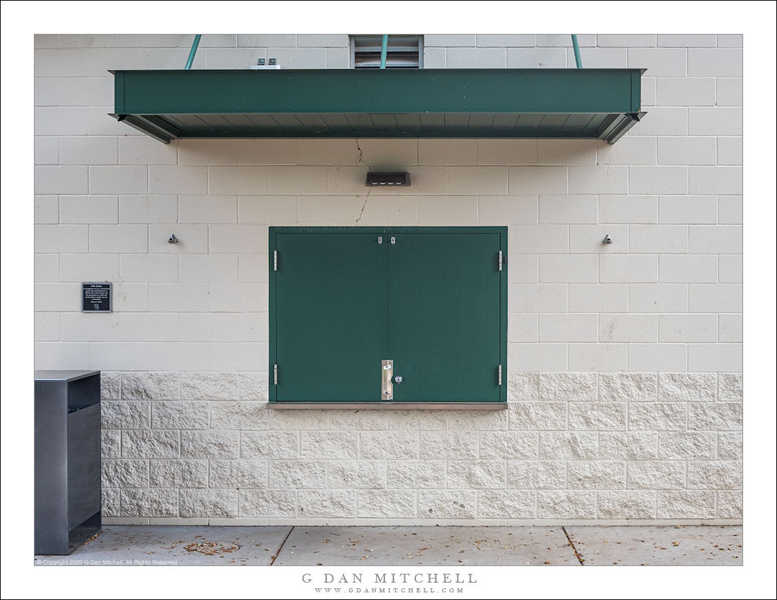
Tag Archives: closed

Boulangerie Coquelicot

Boulangerie Coquelicot
Two people walk past the closed storefront of Boulanger Coquelicot at night, Paris

Boulangerie Coquelicot. Paris. France. August 11, 2016. © Copyright 2016 G Dan Mitchell – all rights reserved.

Two people walk past the closed storefront of Boulanger Coquelicot at night, Paris

This will be a brief post today… I made this photograph last August on an evening in Montemartre when we went out to look for a place to grab dinner. We passed this bakery, a place that our son and daughter-in-law had told us they had visited when they were here a few months earlier, and I figured I should photograph it. The location was quite dark and I was shooting handheld, so the long exposure allowed the furtive, hurrying figures to blur a bit.


G Dan Mitchell is a California photographer and visual opportunist. His book, “California’s Fall Color: A Photographer’s Guide to Autumn in the Sierra” is available from Heyday Books and Amazon.
Blog | About | Flickr | Twitter | FacebookGoogle+ | LinkedIn | Email


All media © Copyright G Dan Mitchell and others as indicated. Any use requires advance permission from G Dan Mitchell.

Gate and Harbor

Gate and Harbor
Closed gate and shadows at South Beach Harbor, San Francisco

Gate and Harbor. San Francisco, California. May 20, 2016. © Copyright 2016 G Dan Mitchell – all rights reserved.

Closed gate and shadows at South Beach Harbor, San Francisco

Up early and on the train to San Francisco on a sunny spring morning, I got off at the SF Caltrain Station and began walking along the waterfront. This is familiar territory to me, since “train walks” are a somewhat regular event for me, especially during spring and summer. I get off the train and slowly wander in one or another direction on foot, taking time to look. Sometimes it turns into and out-and-back walk, and sometimes something like a loop. (The latter is what happened on this morning.)

I decided to hear toward the bay, past AT&T Park and then along the waterfront. I angled over toward the South Beach Harbor, mainly because of the luminous and intense light coming across the bay as the fog began to clear — so bright that it was almost impossible to look directly into it. As I passed the harbor this shadow fell across the walkway, so I stepped back and shot straight into its shadow, with the harbor and the bay behind.


G Dan Mitchell is a California photographer and visual opportunist. His book, “California’s Fall Color: A Photographer’s Guide to Autumn in the Sierra” is available from Heyday Books and Amazon.
Blog | About | Flickr | Twitter | FacebookGoogle+ | LinkedIn | Email


All media © Copyright G Dan Mitchell and others as indicated. Any use requires advance permission from G Dan Mitchell.

Little Italy, Evening

Little Italy, Evening

Little Italy, Evening. New York City. August 10, 2014. © Copyright 2014 G Dan Mitchell – all rights reserved.

Visitors pack closed streets though Manhattan’s Little Italy.

Walking more or less northwest from New York’s Chinatown district after dinner we ended up heading through Little Italy. As we walked on this Sunday evening we started seeing huge crowds of people and we soon figured out why. Apparently the streets through here are closed on Sunday evening, and restaurants tables spill out across the sidewalks, and people end up walking up and down the middle of the streets. The photograph is deceptive — it shows perhaps the smallest number of people that I saw here, and most of the time the streets were packed.

Originally we “planned” (to the extent that we were operating on any kind of plan!) to just walk through here, but it was so lively that we slowed down, stopping for sidewalk gelato, and I made some photographs. The colors were intensified by the diminishing late-day light, and I held my camera above my head and shot blind to get this elevated point of view. Ideally, I think this image works best as a large print, since there are so many small details to look at that aren’t easily visible in this small web version.

G Dan Mitchell is a California photographer and visual opportunist whose subjects include the Pacific coast, redwood forests, central California oak/grasslands, the Sierra Nevada, California deserts, urban landscapes, night photography, and more.
Blog | About | Flickr | Twitter | FacebookGoogle+ | 500px.com | LinkedIn | Email

Text, photographs, and other media are © Copyright G Dan Mitchell (or others when indicated) and are not in the public domain and may not be used on websites, blogs, or in other media without advance permission from G Dan Mitchell.

About the Yosemite “Rim” fire… and more

UPDATE and a NOTE:

Update: Shortly after I posted this, my reports on highway 120 through the park via the Tuolumne Meadows area  were rendered incorrect/outdated by way of an updated announcement from the park service as follows:

“Beginning at 12:00pm on Wednesday, August 28th, Tuolumne Meadows and the High Sierra will only be accessible via Highway 120 East through Lee Vining.  The Tioga Rd/Hwy 120 East will be temporarily closed between White Wolf Lodge and the Big Oak Flat Rd./Hwy 120 West at Crane Flat; the closure is estimated to be 3 to 4 days.  Tuolumne Meadows Lodge, the High Sierra Camps, and Tuolumne Meadows and Porcupine Flat campgrounds all remain open.”

Basically, this means that you will not be able to use highway 120 as a route across the Sierra until further notice. I’m not surprised – in fact, I’ve been somewhat surprised that the road remained open this long. Apparently the following URL is also a good source of updates from the park: http://www.yosemitepark.com/yosemite-fire-update.aspx

Note: All of which brings me back to my original statement that I don’t have inside information on this fire, and that anyone traveling to the area needs to check official sources for conditions updates. I will likely not update this page as things change, so the information posted here should be regarded as potentially being out of date!

My original post follows…

A few people have asked me for information about the “Rim” fire which started not far from Groveland near highway 120, and which is currently burning along the northwest boundary of Yosemite National Park, generally moving east and north toward the highway 108 area. While I know much of this area fairly well from many years (decades, actually) of visits, I do not have any inside information about the fire itself, nor am I an expert on wildfires. One good source of (limited but objective) information is the Stanislaus National Forest Rim Fire Incident web page. A map on this page is a quite amazing source of information, especially when combined with some familiarity with the area and a reading of various written reports. (The version on the main page seems to be based on Google Maps, and allows you to scroll around and zoom in.) Lots of folks who live and work in the area are sharing updates on the usual social media sites. The Mariposa Gazette is another local news source.

The fire started on August 17 more or less midway between Groveland and the  northwest park entrance and not far off of the highway 120 corridor near the Rim of the World area overlooking the canyon of the Tuolumne River. (Highway 120 is a common route for entry to the park from the west and northwest, and it connects via Tuolumne Meadows and Tioga Pass to the east side of the Sierra at the town of Lee Vining.) The spread of the fire at first was somewhat quick, which is no surprise given the extremely dry conditions in the Sierra following a second very dry winter and almost no real precipitation since late 2012. Then, between about August 20 and 23, the fire exploded, expanding  very quickly to cover a huge area generally to the east and north of the starting point, with the fire generally racing northeast but also spreading to the north and south. Continue reading About the Yosemite “Rim” fire… and more