Tag Archives: cove

Coal Chute Point and The Pit

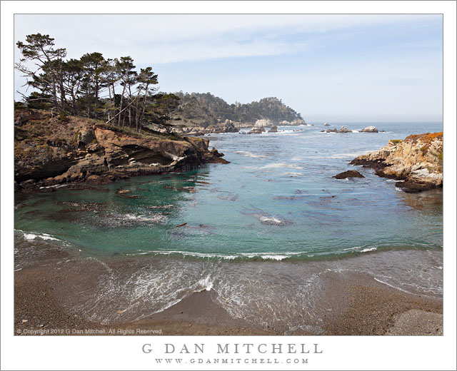
Coal Chute Point and The Pit - Coal Chute Point, the Pit, and the rugged shoreline of Point Lobos State Reserve, California.

Coal Chute Point and The Pit. Point Lobos State Reserve, California. March 29, 2012. © Copyright 2012 G Dan Mitchell – all rights reserved.

Coal Chute Point, the Pit, and the rugged shoreline of Point Lobos State Reserve, California.

(Shortly after posting this, another photographer wrote to suggest that I might consider renaming the image to “Point and Chute.” ;-)

For all the years – decades, actually, and more than a few – that I’ve been visiting Point Lobos, there are still places that I have not gotten around to visiting within the boundaries of the park. Among them are some headlands not far from Whalers Cove that I’ve looked at for a long time… and then always headed off to some other part of the reserve without visiting them. Earlier this week I visited Point Lobos with no particular goal in mind aside from making some photographs, and I somehow finally ended up in this picturesque area that offers some quite different views from those found in the areas that more directly face out into the Pacific. (While it is, indeed, picturesque… the place names are not. Coal Chute Point? The Pit?)

The light in this photograph is somewhat subdued, at least in comparison to some of the photographs you might see of such a place, typically shot in the evening when the sky is at its most colorful. (Yes, I’ve certainly made my share of those photographs at Point Lobos, too!) But this light had a different sort of appeal, and it continuously changed during my half day there. When I arrived some fog was just clearing near the coast. It was a strange pattern – fog way inlands that looked more like the typical winter valley tule fog than the summer coastal fog. In fact, as is frequently the case in winter, it was clear at the coast. But somewhat surprisingly there was a regular old fog bank lurking a ways off the shoreline – and later in the day it moved in on the coast. Along with this there were high, thin clouds from a weather front that was passing well to the north. These conditions can still provide directional light but light which is softer and can fill in the shadows a bit – making it possible to shoot in places and at times of the day when the light might otherwise be too harsh. For this photograph I decided to “go wide,” and shoot with a 24mm focal length of a full frame DSLR to accentuate the distance between the foreground beach and the distant horizon and to include the full width of the curving wave as it broke on the beach.

G Dan Mitchell is a California photographer whose subjects include the Pacific coast, redwood forests, central California oak/grasslands, the Sierra Nevada, California deserts, urban landscapes, night photography, and more.
Blog | About | Flickr | Twitter | FacebookGoogle+ | 500px.com | LinkedIn | Email

Text, photographs, and other media are © Copyright G Dan Mitchell (or others when indicated) and are not in the public domain and may not be used on websites, blogs, or in other media without advance permission from G Dan Mitchell.

Offshore Fog Bank, Marin Headlands

Offshore Fog Bank, Marin Headlands

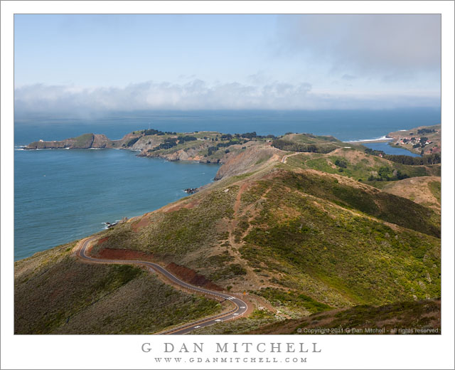
Offshore Fog Bank, Marin Headlands. Golden Gate National Recreation Area, California. July 14, 2011. © Copyright 2011 G Dan Mitchell – all rights reserved.

Offshore fog lies beyond Point Bonita and Rodeo Beach and the Marin Headlands of the Golden Gate National Recreation Area.

I was surprised to find a clear view like this during my mid-July visit to the Marin Headlands of the Golden Gate National Recreation Area (GGNRA) across the Bay from San Francisco. I had almost decided to stay home or go elsewhere based on weather reports that had the coast completely socked in my dense fog for most of the day. Indeed, it was foggy as I passed through San Francisco and drove across the Golden Gate Bridge. The fog was high, and I could see some distance beneath it, but it was still a rather gray day.

Since the lower section of Conzelman Road, the normal quick and scenic route up into the headlands, was closed for construction, I took that alternate route that passes through a tunnel to come out near Rodeo Beach. I turned left up the hill to reach the upper section of the road. After photographing near Battery 129 for a while, the sun began to break through the fog, and I was surprised to find a fairly clear patch just outside the Golden Gate.

The photograph shows the last section of the headlands as the hills drop towards the historic fort and batteries near the Point Bonito light house, which is barely visible at the end of the peninsula on the left. The line of surf at the upper right is Rodeo Beach, a popular spot with Bay Area folks.

G Dan Mitchell Photography
About | Flickr | Twitter | FacebookGoogle+ | 500px.com | LinkedIn | Email

Text, photographs, and other media are © Copyright G Dan Mitchell (or others when indicated) and are not in the public domain and may not be used on websites, blogs, or in other media without advance permission from G Dan Mitchell.
(Basic EXIF data may be available by “mousing over” large images in posts. Leave a comment if you want to know more.)

Monterey Cypress and Coastal Cliffs at Bluefish Cove

Monterey Cypress and Coastal Cliffs at Bluefish Cove

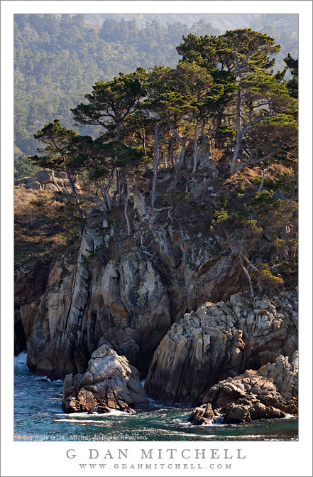
Monterey Cypress and Coastal Cliffs at Bluefish Cove. Point Lobos State Reserve, California. January 8, 2010. © Copyright G Dan Mitchell – all rights reserved.

Monterey Cypress trees grow atop cliffs above Bluefish Cove at Point Lobos State Reserve.

One fun thing about photographing places that I have visited for nearly my full life is that it sometimes encourages me to learn things about places that I had taken for granted – like names of features and places. Although I’ve been to Point Lobos since I was a child and I have seen this area of the reserve many times, I had no idea there was a place called Bluefish Cove, much less that this was it. More accurately, the small patch of water at the foot of this wonderful bit of rocky cliff and cypress forest is Bluefish Cove. I am surprised to note that the point itself seems to be unnamed, at least according to several maps I checked, each of which names many lesser places. The ridge rises from the water to form a peninsula between Bluefish Cove and the larger Whalers Cove. Beyond and above are some of the first coastal hills at what I think of as the north end of the Big Sur coastline.

This photograph is not in the public domain and may not be used on websites, blogs, or in other media without advance permission from G Dan Mitchell.
G Dan Mitchell Photography
FlickrTwitter (follow me) | Facebook (“Like” my page) | LinkedInEmail

Text, photographs, and other media are © Copyright G Dan Mitchell (or others when indicated) and are not in the public domain and may not be used on websites, blogs, or in other media without advance permission from G Dan Mitchell.


Shoreline Plants and Sandstone, Weston Cove

Shoreline Plants and Sandstone, Weston Cove

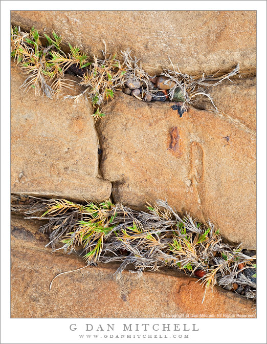
Shoreline Plants and Sandstone, Weston Cove. Point Lobos State Reserve, California. October 23, 2010. © Copyright G Dan Mitchell – all rights reserved.

Plants grow in cracks in the sandstone along the shore of Weston Cove, Point Lobos State Reserve, California.

On this visit to Point Lobos, a place I photograph frequently, I wasn’t quite sure what conditions I would encounter. A Pacific weather front was approaching and I thought that I might encounter dismal, overcast conditions – but I was surprised to find it mostly sunny when I arrived. Even better, high, thin clouds were approaching the coast line and soon muted the direct sunlight, which made photographing these shoreline rock formations a more reasonable possibility during the late morning.

I’m pretty familiar with Point Lobos in general at this point, having visited the place from the time I was a child. I’m especially familiar with Weston Beach (or “cove,” as I like to think of it), with its circular shape, protective rock barrier, angled sandstone edges, and large pebbly “sand.” But as familiar as I am with this location, I almost alway find something new if I look around carefully enough, and these plants growing in the angular cracks in the sandstone were new to me.

This photograph is not in the public domain and may not be used on websites, blogs, or in other media without advance permission from G Dan Mitchell.

G Dan Mitchell Photography | Twitter | Friendfeed | Facebook | Facebook Fan Page | Email