Tag Archives: distance

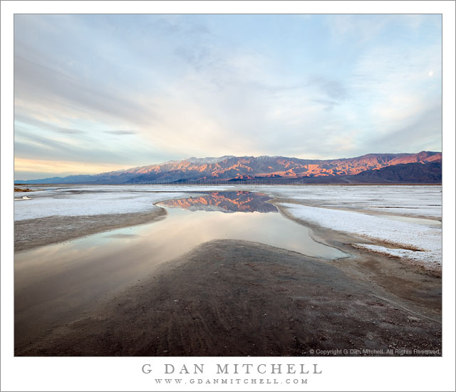
Dawn Light, Panamint Range and Salt Flats

Dawn Light, Panamint Range and Salt Flats

Dawn Light, Panamint Range and Salt Flats. Death Valley National Park, California. February 21, 2011. © Copyright G Dan Mitchell – all rights reserved.

The first dawn light on the snow-dusted Panamint Range is reflected in shallow winter pools on the salt flats of Death Valley National Park.

This is yet another story of serendipity, I think, though it also does involve some advance work – which should please those who become uncomfortable with the idea that not every landscape photograph results from a slow and deliberate and well-planned process! ;-)

The general location of this scene is along a section of salt flat just below the Salt Creek turnoff from the main highway – it is the first area of obvious salt flats that you come to as you head south towards the Furnace Creek area. One one of my first photographic visits to Death Valley I recall stopping near this location along the road and trying to make a photograph pointing down the length of the Valley. It was not successful, but I’ve always been a bit intrigued by this location where the road has to curve around to the east to avoid this salt flat. A day or two earlier on this trip I had stopped along the road at almost this exact location during the “boring light” part of the day after shooting somewhere else. I had wandered – without any camera gear – down across the wash to a patch of brown salt grass and beyond to the edge of the salt flat. I had noticed a lot of things: the very alien nature of this landscape consisting of mud and caked salt and not much else, the surprising presence of some worms and larvae in this tremendously salty water, the fact that the water seemed to seep from beneath the wash, and the interesting shapes that the water created as it slowly spread along the edge of the salt flat.

Move ahead to this morning, the final one of this trip to Death Valley, and I was up well before first light. I had several ideas about what I might photograph, but had not made a firm decision yet since the weather was something of an unknown. I had a vague idea about heading north up the valley and photographing the first light on the hills along its western edge. I was keeping open the possibility that spectacular light might make it worth while to photograph Zabriskie. But I really didn’t know.

I drove to the Furnace Creek/Scotty’s Castle junction and pulled over to watch the light begin to grow. There were lots of clouds! It looked like a lighter area might evolve straight to my east, but I couldn’t quite see photographic potential in it. To the north things looked pretty bleak. There was some possibility that light could happen way to the south, but I wasn’t convinced. I decided to drive a bit south and see what might happen, and very soon I came back to this place where I had stopped earlier. The light wasn’t very promising – clouds to the east seemed likely to block the sunrise light even though there were some interesting cloud patterns overhead that were starting to become more transparent as the sky began to lighten.

Then I caught just a bit of light on some of the higher clouds above the middle level clouds and I started to wonder if the light just might make it through. I went to the back of the car and grabbed my camera with one lens already attached and mounted it on the tripod. I wasn’t sure if I’d want wide or tele for some of the possible subjects, so I grabbed two additional lenses and stuck them in a shoulder bag and headed down the wash, not really looking up too much, just heading straight towards these little areas of water that I remembered from earlier. As I got close to the edge of the flats I saw that, indeed, a band of sunrise light was coming in below the cloud deck to the east (something I have learned to watch for) and starting to light up the highest peaks of the Panamints. I knew that if this light survived long enough to make it down across the range that it was going to happen fast, so I quickly headed out onto the edge of the flats, more or less ignoring the larger scene and simply looking for an interesting reflecting pool. As I set up – working very quickly now – the first sun lit up the face of the panamints and revealed radiating cloud shapes above. I had perhaps two minutes of this light… and then the small gap along the eastern horizon must have closed up as the light disappeared and went back to gray.

G Dan Mitchell Photography | Flickr | Twitter | Facebook | Email
Text, photographs, and other media are © Copyright G Dan Mitchell (or others when indicated) and are not in the public domain and may not be used on websites, blogs, or in other media without advance permission from G Dan Mitchell.

Half Dome and El Capitan, Morning

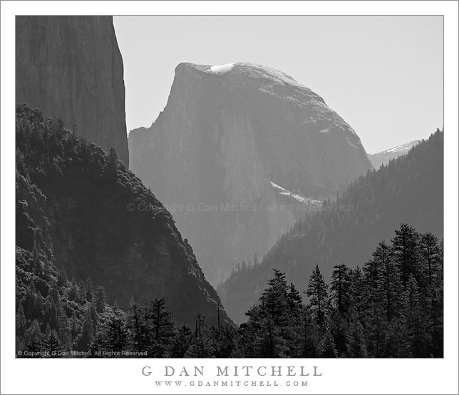
Half Dome and El Capitan, Morning

Half Dome and El Capitan, Morning. Yosemite National Park, California. June 5, 2010. © Copyright G Dan Mitchell – all rights reserved.

Black and white photograph of backlit Half Dome framed by steep Yosemite Valley canyon walls including the face of El Capitan.

Allow me one more photograph in the recent sequence of black and white photographs of “Yosemite icons.” On most drives into and out of the Valley I stop and look at this scene and frequently try to photograph it if the conditions are special. In the morning there is often haze here, and this creates an effect of atmospheric recession from the half dozen or so layers in the scene. It is a tricky thing – a bit too much haze and the details of forest and rock can become almost invisible; too little haze and the contrast between brightly lit highlights (like the patch of snow on Half Dome) and the deep shadows can become quite stark. The image I have in mind includes the effect of atmosphere-highlighted distance, the effect of back-lighting on the trees (most obvious here perhaps at the lower left), and the abstract nature of the different intersecting slopes and faces.

A technical note: I used the Canon 5D2 with the EF 100-400mm zoom at 365mm to make this photograph. Some doubt that a zoom like this can produce enough resolution, but at full size I can just barely make out a couple people on the snow bank atop Half Dome. Sharp enough for me!

This photograph is not in the public domain and may not be used on websites, blogs, or in other media without advance permission from G Dan Mitchell.
G Dan Mitchell Photography | Twitter | Friendfeed | Facebook | Facebook Fan Page | Email

Technical Data:
Canon EOS 5D Mark II
Canon EF 100-400mm f/4.5-5.6 L IS USM at 365mm
ISO 200, f/11, 1/400 second

keywords: yosemite, national, park, sierra, nevada, mountain, spring, nature, valley, half, dome, el capitan, forest, ridge, mountain, cliff, face, back, light, trees, atmosphere, recession, distance, sky, snow, patch, field, summit, canyon, bright, landscape, scenic, travel, california, usa, north america, mariposa, county, haze, stock, black and white, monochrome, morning, highway, 120, icon

Spring Oaks and Santa Cruz Mountains – Castle Rock State Park

Spring Oaks and Santa Cruz Mountains. Castle Rock State Park, California. April 24. 2010.

Spring Oaks and Santa Cruz Mountains - Castle Rock State Park

© Copyright G Dan Mitchell – all rights reserved.

Spring Oaks and Santa Cruz Mountains. Castle Rock State Park, California. April 24. 2010. © Copyright G Dan Mitchell – all rights reserved.

Panoramic photograph of oak trees with new spring growth above the Santa Cruz Mountains descending towards Monterey Bay – Castle Rock State Park.

This is the first (in order of posting) of a few stitched panoramas I made last month. I’ve thought about this shot for a while. It is from at the top of a staircase section of trail at Castle Rock State Park in California, alongside Goat Rock. From this spot you can see all the way to Santa Cruz, the Monterey Bay, and the Monterey Peninsula hills beyond. On this early spring morning the oak trees were just getting their new leaves, so it was still possible to shoot between the branches and see the distant scene where fog filled the bay.

One idea I’m currently working with – among many others – is creating very wide panoramic stitched images of subjects that would usually be shot in a taller format – especially trees. Instead of photographing the entire tree, this feels to me more like looking through the trees at the scene beyond, closer to how I might actually look at this scene if I were there.

This photograph is not in the public domain and may not be used on websites, blogs, or in other media without advance permission from G Dan Mitchell.

G Dan Mitchell Photography | Twitter | Friendfeed | Facebook | Facebook Fan Page | Email

Technical Data:
Canon EOS 5D Mark II
Canon EF 70-200mm f/4 L USM at 131mm
ISO 100, f/16, 1/60 second
three image stitched panorama

keywords: oak, tree, grove, forest, trunk, branch, silhouette, spring, season, growth, new, leaves, santa cruz, monterey, mountains, hills, ridge, valley, summit, county, bay, distance, haze, goat, rock, castle, state, park, california, usa, red, green, nature, scenic, travel, stock, landscape, flora, foliage, plant, north america, west, coast, bay, area, stitched, panorama

Soberanes Canyon, Morning Light

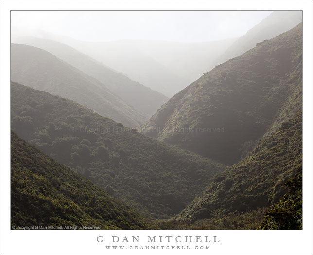
Soberanes Canyon, Morning Light

Soberanes Canyon, Morning Light. Garrapata State Park, Big Sur, California. May 1, 2010. © Copyright G Dan Mitchell – all rights reserved.

Morning light and morning fog fill the upper reaches of Soberanes Canyon, Big Sur, California.

I’ve driven past the trailhead for Soberanes Canyon many times. The trail starts at a curve in the Coast Highway above a popular portion of the rugged beach at Garrapata State Park. This time, as I came past heading south I noticed brilliant light in the steep canyon above the trailhead caused by light shining down from the tops of the peaks through the slightly foggy atmosphere. I didn’t stop right away – I had a different objective further down the coast in mind – but I made a mental note to take a look on my way back north, thinking that I’d probably be back within a half hour or so.

I did return shortly. I parked, loaded up the photo gear, and headed up the trail towards the canyon. I wanted to try to make a photograph that captures the intensity of the light-filled atmosphere created when a steep canyon like this is filled with slightly hazy air – the light is so bright that you almost cannot look at it, but when you do look the light seems almost palpable and the receding ridges of the canyon form interesting patterns before the furthest of them virtually disappear into the light. My first stop was at a small footbridge crossing a creek. This might have made a beautiful photograph – with lush green plants and wildflowers lining the small, rushing creek and the mountains beyond – but I couldn’t find a composition that would work, do so I continued on a bit. Soon I came to a more open area where the trail curved above the floor of the canyon near a cactus-covered slope, and from here the view into the upper reaches of the canyon was unobstructed.

As I framed up several compositions of the ridge patterns of the canyon the light continued to change – one moment it was smooth and undifferentiated, but the next a bit of fog would come through and brilliant clouds would sit on top of the ridge. In the end I wasn’t completely satisfied with the result – but I’m going to think of this as work in progress, and I’ll be back to try to photograph this canyon and these conditions again.

This photograph is not in the public domain and may not be used on websites, blogs, or in other media without advance permission from G Dan Mitchell.
G Dan Mitchell Photography | Twitter | Friendfeed | Facebook | Facebook Fan Page | Email

Technical Data:
Canon EOS 5D Mark II
Canon EF 70-200mm f/4 L USM at 84mm
ISO 125, f/11, 1/400 second

keywords: ridge, atmospheric, recession, distance, canyon, mountain, hill, steep, fog, mist, haze, morning, light, back light, upper, reaches, brush, chaparral, garrapata, state, park, california, usa, north america, big sur, coast, pacific, ocean, highway, trail, scenic, travel, landscape, nature, valley, stock