Tag Archives: hike

Flooded Meadow Near Greenstone Lake

Flooded Meadow Near Greenstone Lake

Flooded Meadow Near Greenstone Lake. Sierra Nevada, California. August 11, 2011. © Copyright 2011 G Dan Mitchell – all rights reserved.

Late-season snow fields are reflected in the pond of a flooded alpine meadow near Greenstone Lake, Sierra Nevada.

During this year of heavy and late winter snowfall, there is still a surprising amount of snow in the Sierra Nevada high country. In the upper portion of this image you can see large snow fields (with much larger ones higher on the slope and out of the frame) at that base of this talus slope at around 10,000+ feet of elevation. During a more typical year, there would still be a few scattered snow fields, but nothing like we see this year. And because there is still so much snow, the plants that would normally be well-developed by now are still just emerging, and the creeks and ponds are overflowing, the meadows are flooded… and the mosquitos are having a field day!

This little pond among the boulder-filled meadows near Greenstone Lake at the far end of Saddlebag Lake was still overflowing with snowmelt water that reflected the extensive snow fields still on the talus field beyond. To get to this spot – in mid-August! – I had to cross a number of still frozen snow fields, follow trails that were flooded in places, and pick my way carefully across waterlogged meadows. It is going to be a short summer season in the high Sierra, but as a compensatory bonus we may still see wildflowers all the way into September.

G Dan Mitchell Photography
About | Flickr | Twitter | FacebookGoogle+ | 500px.com | LinkedIn | Email

Text, photographs, and other media are © Copyright G Dan Mitchell (or others when indicated) and are not in the public domain and may not be used on websites, blogs, or in other media without advance permission from G Dan Mitchell.

(Basic EXIF data may be available by “mousing over” large images in posts. Leave a comment if you want to know more.)

Gaylor Basin and the Cathedral Range, Evening

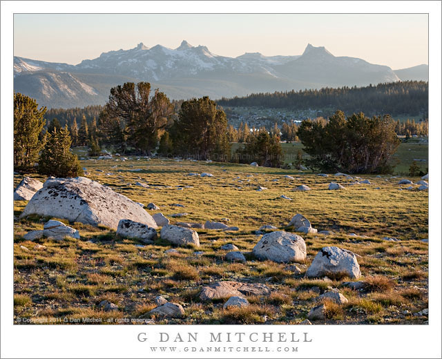
Gaylor Basin and the Cathedral Range, Evening

Gaylor Basin and the Cathedral Range, Evening. Yosemite National Park, California. July 26, 2011. © Copyright 2011 G Dan Mitchell – all rights reserved.

Evening shadows stretch across the boulder-filled meadows and forests of Gaylor Basin with the peaks of the Cathedral Range on the skyline, Yosemite National Park.

On the first evening of my late-July four-day visit to Yosemite’s high country along Tioga Pass Road I decided to visit this favorite location of mine. It is a short (but steep!) hike from near Tioga Pass over a nearby ridge to reach this quiet basin with its many lakes, long distance views of the Cathedral Range, and the treeline terrain of rocks and trees that I believe is my very favorite in the Sierra.

I started out after my mid-afternoon “dinner” and the drive to the trailhead from my camp at Porcupine Flat. Probably because it was so late in the day, I met a fair number of people hiking back out but only saw two others in the entire basin once I arrived. I suppose this is one of the advantages of keeping odd “photographer’s hours” – while most people are heading back to camp to fix dinner, I’m heading out to catch the evening light.

In the end, I didn’t make many photographs on this evening. I mostly wandered, something I love to do in these high open basins. I walked around the first lake, passing over some still-unmelted snow, and crossed the very full outlet stream, trying to skirt the wettest portions of the meadow by looking for rocky terrain. I finally settled on an area just below the lake and made a few photographs of trees and rocks and the long, shallow valley leading toward the main trunk of the Tuolumne River and the mountains beyond. I finished just after dusk, climbed back up the ridge as darkness came on, and finished the hike back to my car with the help of the light from my headlamp.

G Dan Mitchell Photography
About | Flickr | Twitter | FacebookGoogle+ | 500px.com | LinkedIn | Email

Text, photographs, and other media are © Copyright G Dan Mitchell (or others when indicated) and are not in the public domain and may not be used on websites, blogs, or in other media without advance permission from G Dan Mitchell.

(Basic EXIF data may be available by “mousing over” large images in posts. Leave a comment if you want to know more.)
Morning Reflections, Unnamed Lake

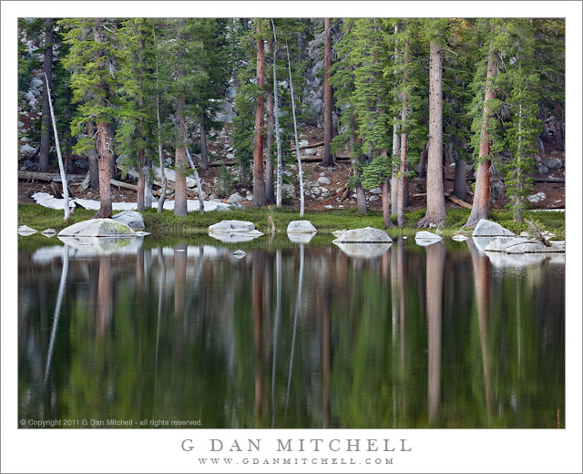
Morning Reflections, Unnamed Lake

Morning Reflections, Unnamed Lake. Yosemite National Park, California. July 29, 2011. © Copyright 2011 G Dan Mitchell – all rights reserved.

The still early morning surface of an unnamed subalpine lake reflects the boulders and trees along its rocky shoreline, Yosemite National Park.

This is yet another of those little places in Yosemite that is both surprisingly accessible and surprisingly neglected. Since keeping it that way may be a good thing, I’ll refrain from locating it more specifically than to say that it is along the Tioga Pass Road through the park.

I have photographed here before, and I am intrigued by the good-sized granite boulders along the shoreline and out into the water of this shallow lake surrounded by forest. Because of the surrounding terrain, morning light does not reach down to th lake right away, so I was able to shoot in this soft and indirect light and include both some details in the shadows of the forest and their beautifully blurred reflections in the still surface of the water.

The photograph includes one indication of what an unusual year this has been in the high country. The horizontal white area beyond the shoreline trees at the left side of the frame is a melting snow bank. Normally that might not be a big deal, but this photograph was made near the very end of July. It is a very unusual year when we can still find snow at this elevation near the beginning of August!

G Dan Mitchell Photography
About | Flickr | Twitter | FacebookGoogle+ | 500px.com | LinkedIn | Email

Text, photographs, and other media are © Copyright G Dan Mitchell (or others when indicated) and are not in the public domain and may not be used on websites, blogs, or in other media without advance permission from G Dan Mitchell.

(Basic EXIF data may be available by “mousing over” large images in posts. Leave a comment if you want to know more.)
Yosemite High Country – A Brief Late July Report

Carefully timing my visit to miss the weekend crowds, I spent the better part of the last week of July (2011) in the Yosemite National Park high country along and around Tioga Pass Road. I posted the first photograph from this visit earlier today, and more will appear here soon. But while the visit is still fresh in my mind, I thought I’d share a few observations and comments that might be useful to others heading there or to other parts of the high Sierra soon.

In a typical late July, all of the snow is melted out at “campground elevations” (generally 8000′ – 9000′ or so – Tuolumne Meadows is at 8600′), essentially all of the usual high country areas are accessible by trail or cross-country travel, wildflowers are at or near their peak, mosquito populations have reached their peak, and visitors are starting to arrive en masse for day use, camping, and backpacking. With the exception of the influx of visitors, this is not quite a typical season, however.

Snow – As I drove up Tioga Pass Road on July 26, the first surprise was finding that there were still large snow patches in some forested areas as low as 8000′ or so. I don’t recall seeing this much snow so low so late in the season in the past. (My memory may not include the lower elevations at this time of year in 1996, the last year with such impressive snow fall.) I stayed at the Porcupine Flat campground, and at least one site there still had enough snow as to make it pretty unusable. Continue reading Yosemite High Country – A Brief Late July Report