
Tag Archives: hill

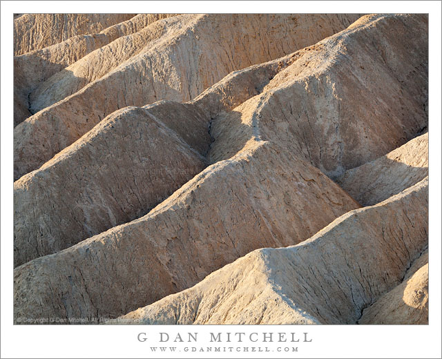
Hills and Gullies, Twenty Mule Team Canyon

Hills and Gullies, Twenty Mule Team Canyon

Hills and Gullies, Twenty Mule Team Canyon. Death Valley National Park, California. April 2, 2009 © Copyright 2009 G Dan Mitchell – all rights reserved.

Morning light across the shapes of hills and gullies, Twenty Mule Team Canyon, Death Valley National Park.

This is a photograph I made back in 2009 when I managed to get to Twenty Mule Team Canyon before sunrise and then continued to shoot for several hours. Though this area is very close to one of the most popular and oft-photographed locations in Death Valley National Park, it gets relatively few visitors from what I’ve seen. While it doesn’t generally present the huge and expansive vistas of some of the more famous areas, it is a great playground for those of us who enjoy the eroded and rounded landforms and the seemingly infinite variations of color and texture.

Here I tried to fill the frame completely with these shapes that have been produced by water eroding the relatively soft earth. The light was very interesting and a bit complex. Some diffused light was coming straight down from the sky, hence the bits of blue shadow in some of the gullies. At the same time, slightly diffused sunlight was directly striking the earth in a few spots. And in some of the foreground areas additional illumination was being reflected into the scene from nearby formations.

G Dan Mitchell Photography
About | Flickr | Twitter | FacebookGoogle+ | 500px.com | LinkedIn | Email

Text, photographs, and other media are © Copyright G Dan Mitchell (or others when indicated) and are not in the public domain and may not be used on websites, blogs, or in other media without advance permission from G Dan Mitchell.
(Basic EXIF data may be available by “mousing over” large images in posts when this page is viewed on the web. Leave a comment if you want to know more.)

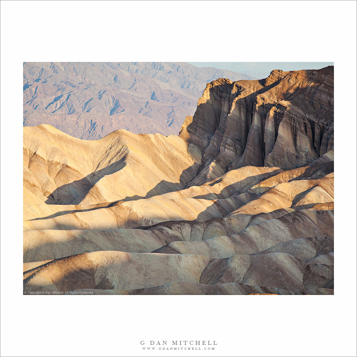
Eroded Gullies at Zabriskie Point, Morning

Eroded Gullies at Zabriskie Point, Morning

Eroded Gullies at Zabriskie Point, Morning. Death Valley National Park, California. April 6, 2006. © Copyright 2011 G Dan Mitchell – all rights reserved.

Low angle morning light illuminates a tortured landscape of eroded gullies at Zabriskie Point, Death Valley National Park.

I recently “rediscovered” this photograph while undertaking a major review of the past eight years of my raw files. (And, yes, that task is just about as much fun as you might imagine. It would actually be pretty unbearable except that every so often I find some photographs that I had perhaps forgotten or overlooked, and I also come across images that remind me of experiences that took place some time ago.)

This photograph was made, as virtually anyone who has visited the spot recognizes, by pointing my camera about 90 degrees to the left of the classic Zabriskie Point views. Timing was important, as the early light is just skimming across the tops of these tortuously eroded gullies, picking out the ridges between them but leaving the lower sections in shadow. But good fortune also played a role here. Death Valley is usually a clear blue sky kind of place, but on this morning I had clouds! At dawn, if I recall correctly, the clouds actually interfered with the light a bit. But as the sun rose the clouds provided a more dramatic background than plain blue sky and created some softer and diffused light that gave just the right sort of dynamic range for photographs.

On a technical note, if you are viewing this in the right web browser you can mouse over the image and see a summary of basic EXIF data. (Sorry, but this feature only works in web browsers – if you are viewing email, etc. you’ll need to visit the version at my blog to see the EXIF.) If you do check the EXIF you might notice that this photograph was made with a very humble example of photographic technology, the Canon Digital Rebel XT. This camera is a 8MP cropped sensor “consumer” camera that I acquired when I first tested the waters of DSLR photography. (I had actually used digital cameras back in the 1990s, but not for serious photographic work.) Those who wonder which of today’s current DSLRs might enable them to produce interesting and effective images might consider what could be done with such a humble camera. ;-)

G Dan Mitchell Photography
About | Flickr | Twitter | FacebookGoogle+ | 500px.com | LinkedIn | Email

Text, photographs, and other media are © Copyright G Dan Mitchell (or others when indicated) and are not in the public domain and may not be used on websites, blogs, or in other media without advance permission from G Dan Mitchell.

(Basic EXIF data may be available by “mousing over” large images in posts. Leave a comment if you want to know more.)

Greenstone Lake, Morning

Greenstone Lake, Morning

Greenstone Lake, Morning. Sierra Nevada, California. August 11, 2011. © Copyright 2011 G Dan Mitchell – all rights reserved.

Early morning light on Greenstone Lake and surrounding trees and rocky terrain.

Greenstone is a relatively small lake just beyond the upper end of Saddlebag Lake, which is itself located just east of the Sierra crest and Yosemite National Park in an area dominated by Mount Conness and the tall ridge on which it stands. I had arrived before dawn at the Saddlebag Lake parking lot so that I could be on the trail before sunrise. Rather than giving in to the temptation to pay for a “water taxi” ride to the other end of the lake, I took the trail along the left shore, and arrived at Greenstone Lake just about the time that the first direct light was making its way down to this lake and the surrounding rocky hillside.

In this wet year with its late arrival of summer conditions, everything was still very wet around the lake and the meadow plants were still green and growing. (In dry years they start to finish up their growth spurt and begin turning brown by this time.)

I think this lake is a bit tricky to photograph in morning light. The light could be lovely at sunrise, but it would still be well up on the high ridges above the lake. It takes a long time for the sun to get high enough to rise above the ridge leading to Tioga Peak, and by that time most of the early morning warm light quality has given way to more typical daytime light. There were a few challenges in this photograph. They included trying to figure out how to find a workable composition in such a complex scene that was made even more complex by the reflections in the water. I think the triangle of rocky terrain in the upper half of the frame may help with this. The light posed several problems, mainly related to the very large dynamic range between the bright rocks and the shaded areas of forest at upper right. The light color was also tricky – because the shadows tend to be much bluer in a photograph than your eyes register when you are there, I had to mute the very blue quality of the shadows. This was done partly with an overall adjustment to color, but some additional work had to be done directly on the shadows.

G Dan Mitchell Photography
About | Flickr | Twitter | FacebookGoogle+ | 500px.com | LinkedIn | Email

Text, photographs, and other media are © Copyright G Dan Mitchell (or others when indicated) and are not in the public domain and may not be used on websites, blogs, or in other media without advance permission from G Dan Mitchell.

(Basic EXIF data may be available by “mousing over” large images in posts. Leave a comment if you want to know more.)

Eastern Sierra Nevada Near June Lake

Eastern Sierra Nevada Near June Lake

Eastern Sierra Nevada Near June Lake. Mono County, California. August 10, 2011. © Copyright 2011 G Dan Mitchell – all rights reserved.

Trees ascend sage-covered hills toward the Sierra Nevada crest near June Lake, California.

Near highway 395 in Mono County, the main north-south route east of the Sierra crest, these open stands of large conifers ascend from the high desert sagebrush country towards the peaks of the Sierra crest, which rise much more abruptly on this side of the range than on the gentle west side. The tall ridge is above the June Lakes resort area between Mammoth Lakes and Lee Vining.

While my primary goal on this trip was to photograph in the Yosemite high country along Tioga Pass Road, smoke from a wildfire near Glacier Point in the park was drifting over the Tuolumne area and creating a lot of very non-photogenic haze. I had a hunch that by dropped over to the east side of the range I might be able to get away from the smoke or at least find areas where it wasn’t so thick. The smoke was still affecting the light near Lee Vining, but I didn’t have to drive too far south to get out of its path, though even here there is a bit of haze increasing the effect of atmospheric recession.

G Dan Mitchell Photography
About | Flickr | Twitter | FacebookGoogle+ | 500px.com | LinkedIn | Email

Text, photographs, and other media are © Copyright G Dan Mitchell (or others when indicated) and are not in the public domain and may not be used on websites, blogs, or in other media without advance permission from G Dan Mitchell.

(Basic EXIF data may be available by “mousing over” large images in posts. Leave a comment if you want to know more.)