
Tag Archives: snow

Spring Torrent, Boulders, and Trees

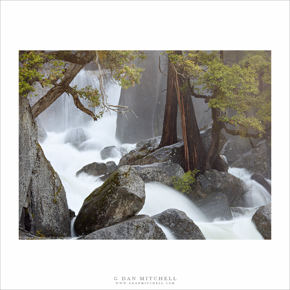
Spring torrent, mist, and trees, Yosemite.
“Spring Torrent, Boulders, and Trees” — Spring snowmelt swells a rushing creek as it rushes past trees and over boulders, Yosemite National Park.

This is a Yosemite National Park cascade that I frequently photograph – at various times of the year including winter, the spring runoff season, and the much quieter and more sedate autumn time. This creek drops precipitously down a steep mountainside (as a number of Yosemite Valley creeks tend to do!) and passes in several place through narrow, twisting, and granite boulder-filled channels.

I made this photograph at almost right around the peak of the spring runoff during an above-average precipitation year, so the water was roaring though this section. The mist that is visible in the photograph was being blown strongly down the canyon and I had to stand in its flow to make this photograph. I recall that I more or less figured out the composition (two actually – one vertical and this one horizontal) before I moved into position, and then I quickly stepped into the mist and made a series of exposures before I and my equipment became too wet, shooting straight into the blowing mist. Now, when I look at this photograph, the memory of the cool, wet air and the tremendous sound of the cascading water comes back to me.

G Dan Mitchell is a California photographer whose subjects include the Pacific coast, redwood forests, central California oak/grasslands, the Sierra Nevada, California deserts, urban landscapes, night photography, and more.
Blog | About | Flickr | Twitter | FacebookGoogle+ | 500px.com | LinkedIn | Email

Text, photographs, and other media are © Copyright G Dan Mitchell (or others when indicated) and are not in the public domain and may not be used on websites, blogs, or in other media without advance permission from G Dan Mitchell.
Snow Geese and Farm Buildings

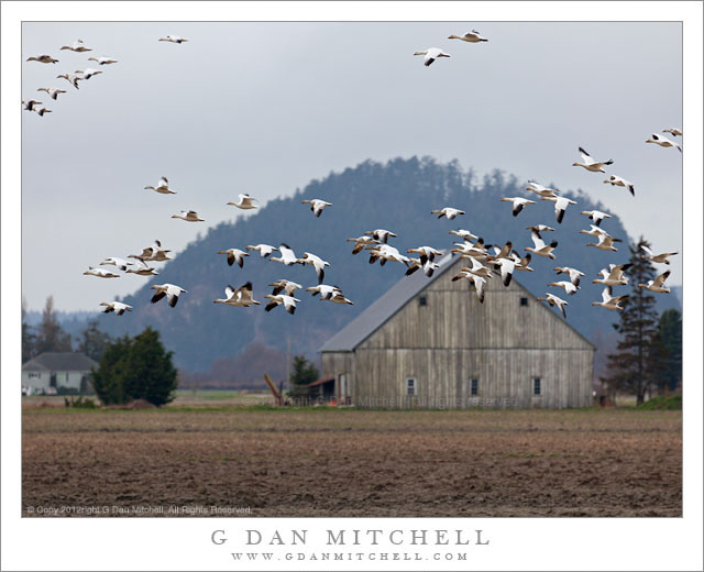
Snow Geese and Farm Buildings - Snow geese fly low past a Skagit Valley farm, Washington.
Snow geese fly low past a Skagit Valley farm, Washington.

Snow Geese and Farm Buildings. Skagit Valley, Washington. February 19, 2012. © Copyright 2012 G Dan Mitchell – all rights reserved.

Snow geese fly low past a Skagit Valley farm, Washington.

Back in February I was fortunate to be able to spend a day photographing migratory (and other) birds in the lower Skagit Valley area in the state of Washington. For me the primary draw was the snow geese, since I had just spent several days photographing Ross’s geese in California’s Central Valley, along with the beautiful trumpeter swans that hang out in the fields in this part of Washington. I had also been alerted to the presence of bald eagles in the area.

I drove up very early in the day from the Seattle area, arriving at just about the time that would have been sunrise… if it had not been a typical gray Washington day. I passed through a small town by the highway and then headed out into this farm country, immediately spotting scattered groups of trumpeter swans, whose large white bodies stand out clearly against the intense green of the new growth in the fields. However, all of these birds were too far from the roads, so I moved on, soon passing what looked like a country produce stand in front of a fallow field that where there were some geese. I stopped – and immediately heard that striking sound of the huge flocks of geese – and got out my camera gear to see what I could do. At this point I looked around a bit more and saw flock after flock of birds high in the sky to the west and heading this direction. Very soon all of these flocks began land on this very field where I had fortuitously stopped and in minutes there were tens of thousands of geese on the ground and many more flying routes above and around the field.

G Dan Mitchell is a California photographer whose subjects include the Pacific coast, redwood forests, central California oak/grasslands, the Sierra Nevada, California deserts, urban landscapes, night photography, and more.
Blog | About | Flickr | Twitter | FacebookGoogle+ | 500px.com | LinkedIn | Email

Text, photographs, and other media are © Copyright G Dan Mitchell (or others when indicated) and are not in the public domain and may not be used on websites, blogs, or in other media without advance permission from G Dan Mitchell.
Tungsten Hills, Buttermilk Country, and the Sierra Crest

Tungsten Hills, Buttermilk Country, and the Sierra Crest - Layers of terrain including Owens Valley sagebrush, the Tungsten Hills, Buttermilk Country, and the Sierra Crest including Basin Mountain, Mount Humphreys, and Mount Emerson
Layers of terrain including Owens Valley sagebrush, the Tungsten Hills, Buttermilk Country, and the Sierra Crest including Basin Mountain, Mount Humphreys, and Mount Emerson

Tungsten Hills, Buttermilk Country, and the Sierra Crest. Round Valley, California. January 2, 2012. © Copyright 2012 G Dan Mitchell – all rights reserved.

Layers of terrain including Owens Valley sagebrush, the Tungsten Hills, Buttermilk Country, and the Sierra Crest including Basin Mountain, Mount Humphreys, and Mount Emerson.

In some ways this is a very typical eastern Sierra Nevada scene but in others, some of which might not be immediately obvious, it is atypical. I made the photograph while on my way to Death Valley in early January 2012. I had done the long drive over Tioga Pass (a first hint about the “unusual” issue) and was headed south to where I would turn east to cross the Inyo Range to that park. As I descended the long grade from Tom’s Place toward Bishop I passed through familiar Round Valley, but this little scene of sagebrush, Sierra foothills, and the crest caught my attention so I quickly stopped and made a few photographs.

The first and primary unusual thing about this photograph is that this was January! In a typical January the peaks here would be completely buried in winter snows – but this January the snowpack brought to mind mid-July. Although the season had started with early and heavy snows in October, things came to an abrupt halt and at this point it had been a month since real snow had fallen. A second slightly unusual thing is that I made this photograph in the mid-afternoon time frame. This is not a time typically regarded as being conducive to landscape photography. However, the high backlight was making the bluish haze more visible and the light was softened a bit by the high clouds, so I went ahead and made a photograph that, I hope, captures the somewhat harsh and dry conditions of the area and the season.

G Dan Mitchell is a California photographer whose subjects include the Pacific coast, redwood forests, central California oak/grasslands, the Sierra Nevada, California deserts, urban landscapes, night photography, and more.
Blog | About | Flickr | Twitter | FacebookGoogle+ | 500px.com | LinkedIn | Email

Text, photographs, and other media are © Copyright G Dan Mitchell (or others when indicated) and are not in the public domain and may not be used on websites, blogs, or in other media without advance permission from G Dan Mitchell.

Tenaya Lake, January 2012

Tenaya Lake, January 2012 - Skaters and walkers on frozen Tenaya Lake, accessible via the still-open Tioga Pass Road on January 16, 2012.
Skaters and walkers on frozen Tenaya Lake, accessible via the still-open Tioga Pass Road on January 16, 2012.

Tenaya Lake, January 2012. Yosemite National Park, California. January 16, 2012. © Copyright 2012 G Dan Mitchell – all rights reserved.

Skaters and walkers on frozen Tenaya Lake, accessible via the still-open Tioga Pass Road on January 16, 2012.

I have been meaning to post this photograph since I made it last month, on January 16, 2012. The serious California drought (or so it seems) of 2012 created very unusual conditions in the Sierra this winter. The Tioga Pass Road (highway 120) through Yosemite National Park usually closes by some time in November, and has been known to close as early as October. The early season this year made it appear that we might have a normal or even heavier than normal winter – early storms near the beginning of October brought a lot of snow to the range and temporarily closed the road more than once. But by December it became clear that this was not going to be a normal year at all, and by the end of the month there was almost no snow anywhere in the range.

A week before this visit I had crossed and re-crossed the pass on a trip to Death Valley. While I appreciated the convenience and shorter drive, I found the odd conditions unnerving. Aside from a few patches here and there, I saw no snow at all, though the seasonal cold had frozen the high country lakes. A week later it looked like a storm or two might finally arrive, so we decided to make the trip up to the Tuolumne area to see the high country in a state that we probably (hopefully!) won’t see again. During the week before this visit, local news stations around California had made this story well known, and they almost all mentioned that people were visiting Tenaya Lake. And, indeed, there were tons of people at the lake when we arrived. There were about as many cars as you might see on an August afternoon. People were clustered along the frozen edge of the lake, were walking along its borders, even setting up tables for picnics on the ice. A few people thought to bring ice skates and they were skating great distances. (Fortunately for us, most people went no farther than Tenaya, and the crowds decreased rapidly after that point.)

G Dan Mitchell is a California photographer whose subjects include the Pacific coast, redwood forests, central California oak/grasslands, the Sierra Nevada, California deserts, urban landscapes, night photography, and more.
Blog | About | Flickr | Twitter | FacebookGoogle+ | 500px.com | LinkedIn | Email

Text, photographs, and other media are © Copyright G Dan Mitchell (or others when indicated) and are not in the public domain and may not be used on websites, blogs, or in other media without advance permission from G Dan Mitchell.