
Tag Archives: trail

Boulders and Trees, Lower Young Lake

Boulders and Trees, Lower Young Lake

Boulders and Trees, Lower Young Lake. Yosemite National Park. September 14, 2010. © Copyright 2010 G Dan Mitchell – all rights reserved.

Subalpine forest strewn with granite boulders in morning light, Lower Young Lake.

This photograph comes from late in last year’s backpacking season, on a mid-September trip to the Young Lakes Basin. As I have previously written, this area is a beautiful one to explore and is doubly beautiful for photographers since it is open to the western evening light. I made this photograph in the morning and not far from my campsite at the lower of the three Young Lakes. This sort of scene is no doubt familiar to anyone who has spent much time in the Sierra Nevada high country and has come to know these areas of mixed trees and meadows among fields of large granite boulders. I found this particular scene by leaving the trail behind and exploring more widely around the shoreline of the lake.

G Dan Mitchell Photography
About | Flickr | Twitter | FacebookGoogle+ | 500px.com | LinkedIn | Email

Text, photographs, and other media are © Copyright G Dan Mitchell (or others when indicated) and are not in the public domain and may not be used on websites, blogs, or in other media without advance permission from G Dan Mitchell.

(Basic EXIF data may be available by “mousing over” large images in posts. Leave a comment if you want to know more.)

Backpacking and Photography

This is the time of year when many of us find our thoughts turning the the upcoming backpacking season. (My home range is the Sierra Nevada, where I have backpacked for decades.) During the past week or two I’ve seen an upsurge in discussions of and questions about photography and backpacking. Several years ago I began posting annual updates on my approach to photography in the backcountry: “Backpacking Photography Equipment.”

G Dan Mitchell Photography | Flickr | Twitter (follow me) | Facebook (“Like” my page) | LinkedIn | Email
Text, photographs, and other media are © Copyright G Dan Mitchell (or others when indicated) and are not in the public domain and may not be used on websites, blogs, or in other media without advance permission from G Dan Mitchell.

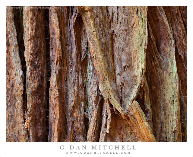
Redwood Trunk, Detail

Redwood Trunk, Detail

Redwood Trunk, Detail. Muir Woods National Monument, California. April 29, 2011. © Copyright G Dan Mitchell – all rights reserved.

Detail view of the convoluted textures of the bark of a coast redwood tree, Muir Woods National Monument.

I’m fascinated by the patterns of tree trunks and bark, and I often try to find ways to make photographs of the thick and rugged bark of coastal redwoods – but not always with a lot of success! The subject is trickier than it seems at first. Even during the daytime these forests can be quite dark – and occasional beams of direct light pose their own problems along the lines of harsh shadows. When shooting close up, relatively small apertures are needed since some amount of DOF is required to get the closest parts of the thick bar, and the deeper parts along the frame edges decently in focus. Low light and small apertures means long exposures, and even a bit of air movement will move leaves, bits of grass, or (in the case of this photo) spider webs. And when a bit of interesting filtered light does make it down through the forest canopy, it is often there and gone within a few seconds. (On this same day I came across a beautiful shadow on the side of one redwood that included the shapes of some nearby alder trees. It was wonderful! It was also gone 10-15 seconds later when I got my camera into position!)

I photographed this bit of bark shape and texture along the main trail at Muir Woods on this late-April morning. As is my usual plan, I had arrived very early – before the park actually opens – and was able to wander around without the typical crowds that appear once the post-breakfast tour buses arrive from nearby San Francisco. In this spot it was quite dark, but there was just a bit of filtered and reflected light to bring out the textures and colors of the redwood bark.

G Dan Mitchell Photography | Flickr | Twitter (follow me) | Facebook (“Like” my page) | LinkedIn | Email
Text, photographs, and other media are © Copyright G Dan Mitchell (or others when indicated) and are not in the public domain and may not be used on websites, blogs, or in other media without advance permission from G Dan Mitchell.

Trail Canyon, Lower Slopes of Wildrose Peak, Death Valley

Trail Canyon, Lower Slopes of Wildrose Peak, Death Valley

Trail Canyon, Lower Slopes of Wildrose Peak. Death Valley National Park, California. March 30, 2011. © Copyright G Dan Mitchell – all rights reserved.

Afternoon shadows fall across the lower slopes of Wildrose Peak above Trail Canyon and below Aguereberry Point, with Death Valley and the Black Mountains beyond.

The view from Aguereberry Point (and from this location close to the point) is spectacular and expansive, taking in everything from Death Valley itself, stretching almost 180 degrees from left to right, to the Green, Black, and other mountains beyond. To the south and north other ranges merge with the atmospheric haze. The peaks of the Panamint range lie behind, and in places where the view is clear you can look down on the rugged terrain of the east face of the Panamint Range with its rugged ridges and deep canyons dropping towards the Valley. This photograph looks roughly southeast towards the lower end of Death Valley in the area around Ashford Mill. The deep foreground canyon, the bottom of which is just visible at lower right, is Trail Canyon. I understand that a four-wheel-drive road used to come up to Aguereberry Point via that canyon, but that parts have washed out and it can no longer be driven. I think that you can hike it, but that would be one heck of a climb since the base of the canyon can’t be more than a few hundred feet above Death Valley (which is below sea level in this area) and the Point is well above 6000′. The lower slopes of Wildrose Peak rise beyond the canyon.

Surprisingly, this view presents several photographic challenges. Because of the haze that appears when such great distances are part of the scene, I chose to use a polarizing filter for this shot. Timing is important here, too. Arrive a bit too early and the light is harsh and flat. Arrive a bit too late and the foreground ridges are quickly enveloped in shadows as the sun drops behind the crest of the Panamint Range. (Yes, I have made both mistakes in the past.) Knowing this, I arrived a bit earlier than I might have usually arrive to shoot evening light and I managed to photograph the scene before that Panamint Range shadow obliterated the foreground light.

G Dan Mitchell Photography | Flickr | Twitter | Facebook | Email
Text, photographs, and other media are © Copyright G Dan Mitchell (or others when indicated) and are not in the public domain and may not be used on websites, blogs, or in other media without advance permission from G Dan Mitchell.