Tag Archives: travel

Fiery Furnace, Arches National Park

Fiery Furnace, Arches National Park

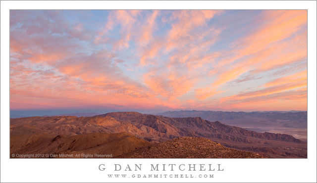
Fiery Furnace, Arches National Park. Arches National Park, Utah. October 11, 2012. © Copyright 2012 G Dan Mitchell – all rights reserved.

Ridges and mesas recede into the distance beyond Fiery Furnace formations, Arches National Park.

These formations are part of a much larger set of similar structures along the road toward the Devil’s Garden area of Arches National Park. They overlook a large section of the park and beyond. The distant plateau in the sunlight is along the Colorado River, and though they are not visible in this photograph the La Sal Mountains tower even further off. Between there is a lot of rough country full of valleys and ridges and other formations.

The Fiery Furnace area contains sandstone with layers of contrasting color, as see here. This material has been eroded it all sorts of fantastical ways. On this particular day, the light conditions were both interesting and challenging. There were quite a few high clouds and a good portion of the time the sun was blocked by them and the light was somewhat dismal. But as the clouds moved along, the sun light occasionally broke through gaps and cast beams of light that traversed the landscape. When we first stopped here and saw the overcast conditions I almost decided to just move on. But I saw a few hints of this changeable light and decided to try patience first! It took a while, but eventually some of the clear areas in the overcast lined up with our position and we had moments of nice light.

G Dan Mitchell is a California photographer and visual opportunist whose subjects include the Pacific coast, redwood forests, central California oak/grasslands, the Sierra Nevada, California deserts, urban landscapes, night photography, and more.
Blog | About | Flickr | Twitter | FacebookGoogle+ | 500px.com | LinkedIn | Email

Text, photographs, and other media are © Copyright G Dan Mitchell (or others when indicated) and are not in the public domain and may not be used on websites, blogs, or in other media without advance permission from G Dan Mitchell.

Dawn Sky, Panamint Range

Dawn Sky, Panamint Range

Dawn Sky, Panamint Range. Death Valley National Park, California. January 5, 2012. © Copyright 2012 G Dan Mitchell – all rights reserved.

First dawn light on clouds above Death Valley, as seen from high in the Panamint Range

I recently “discovered” (or perhaps “remembered?”) this photograph that I made nearly a year earlier during an early January 2012 trip to do winter photography in Death Valley National Park. Winter is a wonderful time in Death Valley, though the season can present its own challenges – not the same as summer, but challenges nonetheless. The challenges include, believe it or not, the possibility of some very, very cold weather, especially in some of the higher outlying areas of the park an up in the mountains, such as here in the Panamint Range. But there are special rewards, too, including the possibility of snow among the peaks and the more interesting skies that can come with the passage of winter low pressure systems that originate in the Pacific Ocean.

On this morning I had gotten out of my sleeping bag well before dawn so that I would have time to drive to this overlook high in the Panamints before sun rise. It was still dark as I drove the last section of the gravel road approach, and its wasn’t until after I arrived that there was enough light to see that this might turn out to be a spectacular sunrise. (When you get up in darkness and drive many miles, you have to take it on faith that something special might occur, and accept the possibility that it might not.) My original subject ideas for this location were not so much about sky as about deep valleys and receding ridges, but when the first sun hit these high clouds I was willing to angle the tripod up a bit to photograph them! This light on the clouds only lasted a few minutes, and after that I turned my attention back to the landscape below.

G Dan Mitchell is a California photographer and visual opportunist whose subjects include the Pacific coast, redwood forests, central California oak/grasslands, the Sierra Nevada, California deserts, urban landscapes, night photography, and more.
Blog | About | Flickr | Twitter | FacebookGoogle+ | 500px.com | LinkedIn | Email

Text, photographs, and other media are © Copyright G Dan Mitchell (or others when indicated) and are not in the public domain and may not be used on websites, blogs, or in other media without advance permission from G Dan Mitchell.

Red Rock at Dusk

Red Rock at Dusk
Red Rock at Dusk

Red Rock at Dusk. Capitol Reef National Park, Utah. October 8, 2012. © Copyright 2012 G Dan Mitchell – all rights reserved.

Red rock sandstone cliffs at dusk in the Fruita area of Capitol Reef National Park, Utah.

The farther mesa or tableland is a prominent feature of the Fruita District area of Capitol Reef National Park as seen when approaching from the west – though here it is photographed from a slightly different point of view that is more to the south. There is a prominent feature – not seen in this photograph – along the upper rim of these cliffs that is known as “The Organ,” and which is pointed out in guides and maps to the area. However, I’m surprise that the spectacular cliff and mesa itself seems to either not have a name or else have a name that is not widely known. I asked about this when I was there, and several people who should know did not know of a name for it, and one suggested a name that comes from another feature that is more general.

Nonetheless, these cliffs certainly impress me, named or not! The photograph was made rather late in the day, as the sun was just about to drop above the edge of the higher country to the left/west of here. Thin clouds somewhat diffused and softened the evening light, but not so much as to remove the warm coloration of the light. Among the strata visible here is one along the low ridge at front right that contains starkly differentiated layers of lighter and darker rock. Near the far lower left corner is a small area of trees that is not far from the campgrounds of the Fruita area.

G Dan Mitchell is a California photographer and visual opportunist whose subjects include the Pacific coast, redwood forests, central California oak/grasslands, the Sierra Nevada, California deserts, urban landscapes, night photography, and more.
Blog | About | Flickr | Twitter | FacebookGoogle+ | 500px.com | LinkedIn | Email

Text, photographs, and other media are © Copyright G Dan Mitchell (or others when indicated) and are not in the public domain and may not be used on websites, blogs, or in other media without advance permission from G Dan Mitchell.

Room for the Big Deep Bend

Room for the Big Deep Bend
“Room for the Big Deep Bend” — Scowercroft’s Never Rip Overalls – Room for the Big Deep Bend

At about the time I made this photograph, we were staying in Torrey, Utah for a few days. Instead of doing the obvious thing and heading east to visit Capitol Reef National Park again, we headed west towards points unknown but including the Fish Lake area. We passed through small towns whose lives seemed more divorced from the tourist trade than others we had been through along route 12, and eventually turned off the main highway to head up to Fish Lake. It turned out that, at least partially as a result of my decision to not do too much research ahead of time, we had missed the main fall color season there and that, in fact, the whole place was pretty much shutting down for the season. We poked around a bit here before reversing direction and heading back to highway 24.

Rather than end our exploration quite so soon, we continued on along highway 24, soon turned off into the Valley where Koosharem is located. I cannot recall now what drove the decision to go there – perhaps the unusual name of the place or maybe the possibility of getting to mountains on the far side of the valley – but there we went. We initially pretty much drove right through Koosharem and on out into the country on the other side of town, but we soon stopped and decided that this was not the direction we really wanted to go. We turned around and headed back towards Koosharem. This time a few things caught our attention, including the plain architecture of certain buildings in the town and the surprising – to us, anyway – appearance of this antiquated looking, though clearly kept up, sign on the side of this building next to a leave littered parking area that also held an ATV and some sort of small trailer. I wondered about this sign and the advertising copy it contained, and I later found out that Scowercroft and Sons was a fairly large manufacturer of clothing centered in Ogden.


COMMENT OR QUESTION? Scroll down to the comment form.

G Dan Mitchell is a California photographer and visual opportunist. His book, “California’s Fall Color: A Photographer’s Guide to Autumn in the Sierra” (Heyday Books) is available directly from him. Blog | Bluesky | Mastodon | Substack Notes | Flickr | Email

All media © Copyright G Dan Mitchell and others.