Tag Archives: Cloud

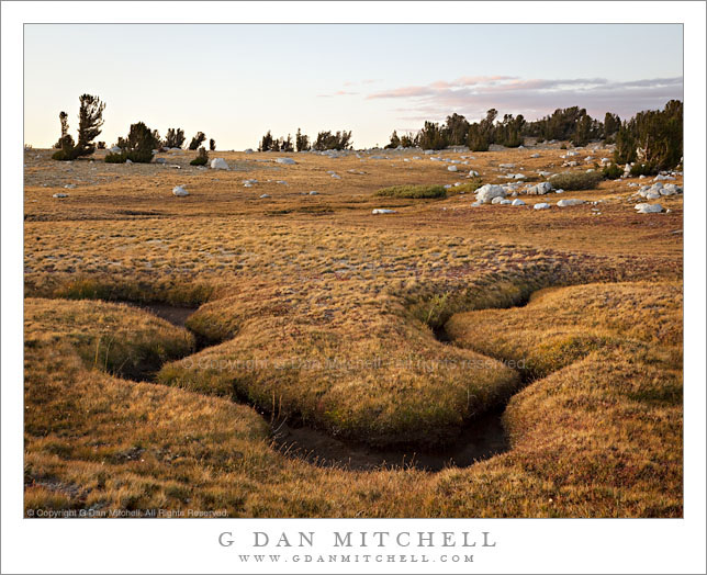
Subalpine Meadow, Evening – Evelyn Lake

Subalpine Meadow, Evening - Evelyn Lake

Subalpine Meadow, Evening – Evelyn Lake. Yosemite National Park, California. September 8, 2009. © Copyright G Dan Mitchell – all rights reserved.

Late summer evening light in a subalpine meadow near Evelyn Lake in the Yosemite National Park back-country.

I’m pretty certain that my favorite time of year in the Sierra starts right about when this photograph was made – early September right after the Labor Day Holiday. I’m also certain that my favorite terrain – I call in “my Sierra” – is this sort of open timberline country with a mixture of subalpine meadow, stunted forest, and open views of surrounding higher terrain.

On this day I had come up to Evelyn Lake – located very near the Vogelsang High Sierra camp – from Lyell Canyon. After a late arrival at my Lyell Canyon camp the night before and the rather stiff morning climb up the Ireland Lake trail, I arrived here feeling pretty tired. I pretty much set up my bivy sack camp and took a big nap! Later in the day as evening approached I came back to life and decided to make a few photographs. This photograph of the meadow and a bit of a meandering stream in the meadow was made within a few yards of my campsite on the shoreline of the lake.

This photograph is not in the public domain and may not be used on websites, blogs, or in other media without advance permission from G Dan Mitchell.

G Dan Mitchell Photography | Twitter | Friendfeed | Facebook | Facebook Fan Page | Email

keywords: stream, creek, meander, meadow, grass, plant, foliage, flora, rock, boulder, tree, forest, sub, alpine, tundra, ridge, rocky, sky, blue, cloud, cloud, pastel, sunset, evening, dusk, light, evelyn, lake, back, country, backpack, trail, hike, camp, nature, landscape, travel, yosemite, national, park, california, usa, stock

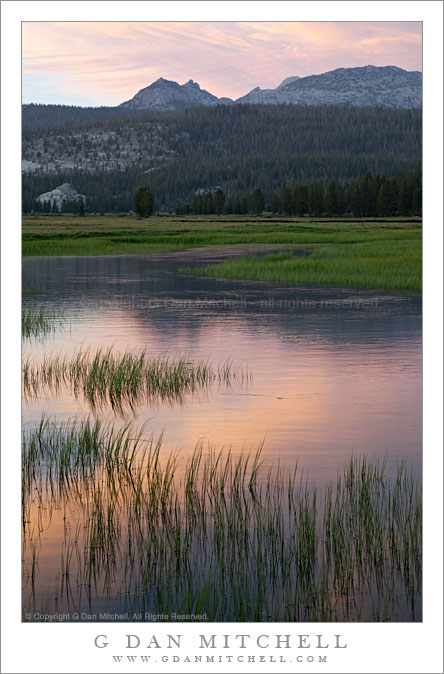
Runoff Pool, Evening – Tuolumne Meadows

Runoff Pool, Evening - Tuolumne Meadows

Runoff Pool, Evening – Tuolumne Meadows. Yosemite National Park, California. July 7, 2009. © Copyright G Dan Mitchell – all rights reserved.

Grass bordered early summer runoff pool in Toulumne Meadows reflects sunset clouds and the summit of Ragged Peak, Yosemite National Park, California.

I made this photograph on a very early-season visit to the Tuolumne Meadows area in early July of this year. Since this was a below-normal precipitation year, the road to the pass cleared a bit on the early side and by early July almost all of the snow was gone at road level – but there was still a good amount of run-off water in Tuolumne Meadows. (Though nothing like in the big precipitation years, when portions of the meadow become more lake than solid ground.) There were some interesting clouds this evening so I wandered out into one of my favorite areas in the lower end of the meadow as the day ended and photographed the new grasses and pools of water that reflected sky, clouds, and surrounding peaks. In the distance the summit of Ragged Peak marks the location of Young Lakes.

This photograph is not in the public domain and may not be used on websites, blogs, or in other media without advance permission from G Dan Mitchell.

G Dan Mitchell Photography | Twitter | Friendfeed | Facebook | Facebook Fan Page | Email

keywords: tuolumne, meadow, tioga, pass, road, sierra, nevada, mountains, range, yosemite, national, park, california, usa, reflection, runoff, pool, water, surface, grass, ripple, cloud, evening, sunset, dusk, summit, ragged, peak, ridge, forest, granite, blue, orange, green, nature, july, early, summer, nature, landscape, scenic, travel, stock

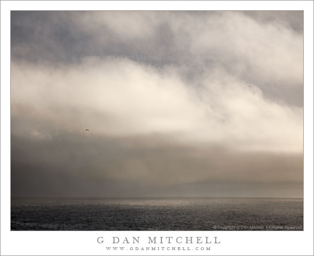
Squall, Point Lobos

Squall, Point Lobos

Squall, Point Lobos. Point Lobos State Reserve, California. November 22, 2009. © Copyright G Dan Mitchell – all rights reserved.

This photograph is not in the public domain and may not be used on websites, blogs, or in other media without advance permission from G Dan Mitchell.

An offshore squall in the wake of a frontal passage, Point Lobos State Reserve, California.

Shortly after I arrived to photograph at Point Lobos in what looked like it might become fairly photogenic weather, I was surprised by a small cold front that quickly swept across the part and left some mist in its wake. It passed quickly and after the offshore showers had passed the sun soon began to return – in fact a half hour later it was almost completely clear at sunset.

I have a long term project of photographing what I think of as minimalist seascapes and this is another in the series. Many are made during the “interesting” season along the northern and central California coastline – the season that includes late fall, winter, and early spring. During this half of the year, rather than the summer’s binary alternation between boring blue sky and dense coastal fog we seek a tremendous range of local and larger area conditions. Yes, the fog is still around, but we also see the gloom of approaching fronts, the power of Pacific storms, the mixed light and clouds and these storms clear, and the tremendously clear air after the last remnants of a front departs.

One more comment on this photograph. I think this may be one of those in which the inclusion of a very tiny object can have an effect on the perception of the image that is way our of proportion to its size. What looks like a small spot in the sky on the left side of the frame in this online jpg is a solitary bird passing across the scene. I feel that this photograph is changed in an important way by its inclusion.

G Dan Mitchell Photography | Twitter | Friendfeed | Facebook | Facebook Fan Page | Email

keywords: point, lobos, state, park, reserve, carmel, monterey, peninsula, big, sur, california, usa, ocean, sea, pacific, coast, shore, scenic, stock, travel, nature, squall, shower, rain, weather, cold, front, storm, cloud, water, light, seascape, landscape, horizon, stock

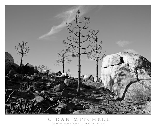
Burn Zone, Near Foresta

Burn Zone, Near Foresta

Burn Zone, Near Foresta. Yosemite National Park, California. October 31, 2009. © Copyright G Dan Mitchell – all rights reserved.

Trees, stumps, and boulders in a recently burned area near Foresta, Yosemite National Park, California.

The story behind this photograph is a sad one, and one that provokes a certain amount of anger. The small village of Foresta is just on the western boundary of Yosemite National Park, above El Portal and below the road into Yosemite Valley from the highway 120 northern park entrance. A number of years ago – seems like perhaps 15 or so, though I haven’t looked it up – a tremendous fire started near Foresta and burned quickly and very destructively through a mature forest that had gone too long without burning. Because of the build-up of litter on the forest floor, the fire burned unusually hot and not only consumed small trees and low-lying plants but also destroyed a complete mature forest between Foresta and Tioga Pass Road where it finally was stopped.

This was one of the fires that probably made clear the terrible risks forests were facing due to many years of fire suppression – these forests evolved in a world of periodic fires and smaller fires to clear out the undergrowth the inevitable big fire has so much fuel to feed upon that the damage to the forest is ultimately much worse. For this reason, Yosemite (along with other parks) has adopted a wise policy of letting natural fires burn out on their own. Personnel are dispatched to keep an eye on the fire and to ensure that it doesn’t get out of control or threaten people or structures, but otherwise the fires are allowed to burn naturally. The price of some additional late summer smoke is, I think, a small price to pay for a more healthy forest.

After that original fire, what had previously been a forest along this section of the road instead became an open area. At first many small plants and wildflowers took advantage of the sunlight and grew like crazy. Eventually larger trees began to grow and in the past few years it was almost possible to imagine that a forest like the original one might eventually return.

One day in August this past summer I was camped in the Ten Lake Basin to do photography. On the second to last day I decided to leave my base camp and instead plan a dry camp on top of a ridge above the Basin from which I had seen a tremendous panorama of the Sierra crest on my way in. I packed up, carrying extra water, and climbed the steep trail to the pass. But as I climbed I smelled smoke, and as I came to the summit I saw a plume of forest fire smoke to the west… in the direction of Foresta. I gave up on the photography and hiked on out. I eventually found out that NPS personnel had been conducting a “management fire” near Foresta (on a very hot and dry summer day!) when it got out of control. This “little fire” burned right out of the Foresta area and into the surrounding hills and valleys, eventually consuming thousands of acres… including a good portion of the area of the previous fire that had slowly been starting to recover.

The tragedies of this fire are several. First, it is troubling that those in charge of actions designed to lessen fire damage to the forest miscalculated so badly that they ended up destroying substantial areas of the forest they were to protect. Even worse, the recovery of this area has now been set back by years, and perhaps decades.

This photograph is not in the public domain and may not be used on websites, blogs, or in other media without advance permission from G Dan Mitchell.

G Dan Mitchell Photography | Gallery | Twitter | Friendfeed | Facebook | Facebook Fan Page | Email

keywords: yosemite, national, park, valley, sierra, nevada, mountain, range, autumn, fall, season, scenic, travel, nature, landscape, california, wildfire, burn, zone, ash, boulder, rock, stump, tree, dead, sky, cloud, dirt, branch, forest, fire, foresta, nature, black and white, shadow, ecology, stock, desolation