Tag Archives: fort

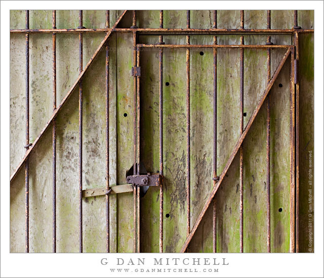
Rusted Gate and Concrete Wall, Battery 129

Rusted Gate and Concrete Wall, Battery 129

Rusted Gate and Concrete Wall, Battery 129. Golden Gate National Recreation Area, California. July 14, 2011. © Copyright 2011 G Dan Mitchell – all rights reserved.

Rusted gate against a weathered concrete wall at the entrance to a tunnel at Battery 129, Golden Gate National Recreation Area.

At the north end of the Golden Gate Bridge, Conzelman Road leads up into the Marin Headlands along the San Francisco Bay side of the ridge. This road is a favorite place for overlooking the Golden Gate and its famous bridge along with a large expanse of San Francisco and its Bay and points east. In mid-July the road was not accessible from the usual spot near the end of the bridge, so I detoured around towards the “back entrance” via the road to Rodeo Beach. From this road I turned up into the hills and joined Conzelman near its summit. I made a few foggy photographs of the Bay, but my main interest was in trying to find photographs in the old batteries and other abandoned military facilities along the ridge running out toward Point Bonita.

At the summit of the hill, before the road becomes very narrow and many people turn back, is “Battery 129.” There are several tunnels into this facility from alongside the road and a separate route leads up the hill to the old structures on the summit. I took one of the two tunnels under the hill and as I entered the second section I saw this old metal gate against a weathered concrete wall, illuminated by light leaking in from the end of the tunnel.

G Dan Mitchell Photography
About | Flickr | Twitter | FacebookGoogle+ | 500px.com | LinkedIn | Email

Text, photographs, and other media are © Copyright G Dan Mitchell (or others when indicated) and are not in the public domain and may not be used on websites, blogs, or in other media without advance permission from G Dan Mitchell.

(Basic EXIF data may be available by “mousing over” large images in posts. Leave a comment if you want to know more.)

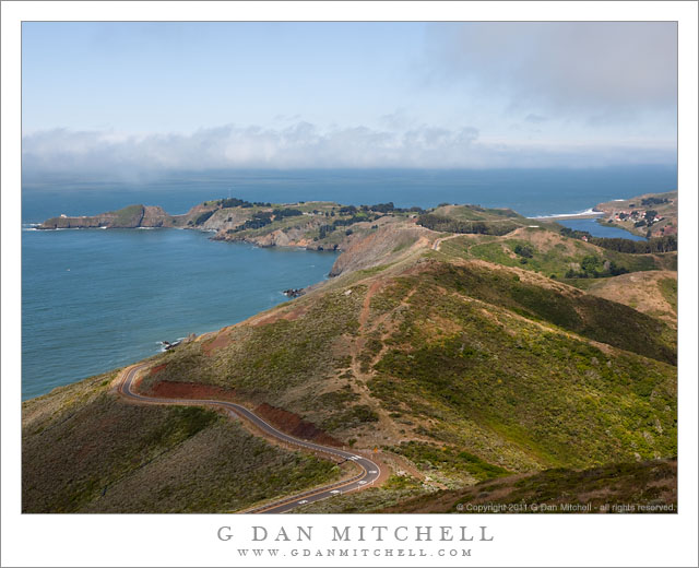
Offshore Fog Bank, Marin Headlands

Offshore Fog Bank, Marin Headlands

Offshore Fog Bank, Marin Headlands. Golden Gate National Recreation Area, California. July 14, 2011. © Copyright 2011 G Dan Mitchell – all rights reserved.

Offshore fog lies beyond Point Bonita and Rodeo Beach and the Marin Headlands of the Golden Gate National Recreation Area.

I was surprised to find a clear view like this during my mid-July visit to the Marin Headlands of the Golden Gate National Recreation Area (GGNRA) across the Bay from San Francisco. I had almost decided to stay home or go elsewhere based on weather reports that had the coast completely socked in my dense fog for most of the day. Indeed, it was foggy as I passed through San Francisco and drove across the Golden Gate Bridge. The fog was high, and I could see some distance beneath it, but it was still a rather gray day.

Since the lower section of Conzelman Road, the normal quick and scenic route up into the headlands, was closed for construction, I took that alternate route that passes through a tunnel to come out near Rodeo Beach. I turned left up the hill to reach the upper section of the road. After photographing near Battery 129 for a while, the sun began to break through the fog, and I was surprised to find a fairly clear patch just outside the Golden Gate.

The photograph shows the last section of the headlands as the hills drop towards the historic fort and batteries near the Point Bonito light house, which is barely visible at the end of the peninsula on the left. The line of surf at the upper right is Rodeo Beach, a popular spot with Bay Area folks.

G Dan Mitchell Photography
About | Flickr | Twitter | FacebookGoogle+ | 500px.com | LinkedIn | Email

Text, photographs, and other media are © Copyright G Dan Mitchell (or others when indicated) and are not in the public domain and may not be used on websites, blogs, or in other media without advance permission from G Dan Mitchell.

(Basic EXIF data may be available by “mousing over” large images in posts. Leave a comment if you want to know more.)
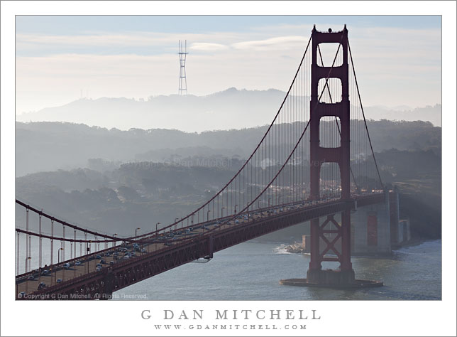
Sutro Tower and Golden Gate Bridge South Tower, Morning

Sutro Tower and Golden Gate Bridge South Tower, Morning

Sutro Tower and Golden Gate Bridge South Tower, Morning. San Francisco, California. December 18, 2009. © Copyright G Dan Mitchell – all rights reserved.

Morning traffic crosses the Golden Gate Bridge approaching the south tower with haze-shrouded San Francisco hills and Sutro Tower beyond.

I’ve played around with photographs of the south end of the Golden Gate Bridge from this iconic location above the north end of the Bridge before, including some night photography, but I’ve never quite been happy with the composition. On this morning I got lucky with the thin fog muting the colors and creating atmospheric recession into the distant hills and the warm morning light on the upper surface of the bridge. In addition I tried a different composition – instead of trying to fit the whole bridge into the frame I centered the photo on the curve of the distant ridge and then selected a focal length that included a bit of water, a bit of the area to the right of the bridge, and a good portion of the span with just enough morning traffic. The distant structure is Sutro Tower, the site of a number of San Francisco radio and television broadcast antennas.

This photograph is not in the public domain and may not be used on websites, blogs, or in other media without advance permission from G Dan Mitchell.

G Dan Mitchell Photography | Twitter | Friendfeed | Facebook | Facebook Fan Page | Email

keywords: california, usa, travel, scenic, san francisco, bay, area, golden, gate, national, recreation, area, park, stock, sutro, south, tower, cable, suspension, bridge, traffic, cars, morning, haze, fog, distance, hills, trees, water, waves, highway, 101, 1, clouds, atmosphere, recession, silhouette, urban, landscape, commute, span, shore, fort, mason, stock

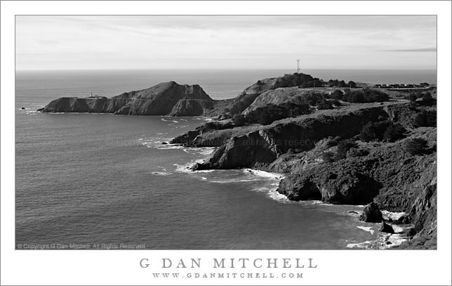
Point Bonita, Pacific Ocean

Point Bonita, Pacific Ocean

Point Bonita, Pacific Ocean. Marin Headlands, California. December 18, 2009. © Copyright G Dan Mitchell – all rights reserved.

Black and white photograph of morning light on coastal cliffs and beaches near the Point Bonita Lighthouse in the Marin Headlands with the Pacific Ocean beyond – Golden Gate National Recreation Area.

This photograph represents another “stop the car, back up, and shoot this now!” moments – the second one during a single weekend.

I had taken a long day to photograph north of San Francisco, ostensibly with the excuse of having to meet someone in the City that evening – heck, might as well leave early and spend the day shooting, right? I had only vague plans to head across the Golden Gate Bridge when I started out that morning, but I stopped near the north end and headed up into the Marin Headlands when I saw some pretty special lighting and atmospheric conditions over the Bay. After shooting that general subject (including photos of the Bridge, the Bay, and the City posted earlier and still to come) I drove on up the road and then out toward Point Bonita.

The last part of this road is a narrow, twisty one-way drive high on the coastal hills above the outer reaches of the Golden Gate. As I came around one turn the view opened up and I saw – for the first time, though I’ve been here before – this great view of Point Bonita and the Pacific. I quickly stopped, set up, and made a few exposures.

The Point Bonita area is an interesting one. All along this section of the Marin Headlands are found old forts and artillery sites, supposedly to protect the Bay from invasion by sea. There is no longer a military presence here – this is now part of the Golden Gate Recreation Area, but many of the historic sites remain. Point Bonita itself is the site of a lighthouse at the north edge of the entrance to San Francisco Bay. It is a wild place. Not only it is in a spectacular location of tall coastal bluffs and steep cliffs that is fully open to the power of the Pacific, but the lighthouse itself is on a small island set slightly apart from the main landmass. The only way to get to it is to walk a trail along the steep cliffs – which passes through a tunnel at one point – then cross the top of the low bluff, and then walk the bridge to the small island.

This photograph is not in the public domain and may not be used on websites, blogs, or in other media without advance permission from G Dan Mitchell.

G Dan Mitchell Photography | Twitter | Friendfeed | Facebook | Facebook Fan Page | Email

keywords: california, usa, travel, scenic, san francisco, bay, area, golden, gate, national, recreation, area, park, stock, marin, county, headlands, point, bonita, fort, historic, beach, coast, shore, pacific, ocean, coastline, waves, surf, horizon, sky, clouds, bluffs, rocks, island, trees, nature, landscape, seascape, tower, antenna, trail, road, travel, scenic, black and white, monochrome, stock, morning, light