Tag Archives: gravel

Titus Canyon Road

Titus Canyon Road
Titus Canyon Road

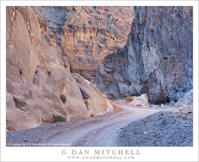
Titus Canyon Road. Death Valley National Park, California. December 11, 2013. © Copyright 2014 G Dan Mitchell – all rights reserved.

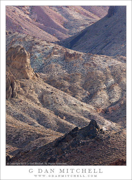
Titus Canyon Road descents into upper Titanothere Canyon before climbing to Red Pass

Early December is a fine time to be in Death Valley National Park, and I managed to spend five days there this past December. The weather is cooler this time of year – in fact, temperatures dropped into the upper twenties in the Valley during my visit and well down into the teens in some of the upper elevations that I visited during the pre-dawn hours. Although seasoned Death Valley visitors prefer to visit during the cooler months, things seem much quieter than a few months later in the spring. In fact, I almost had the entire Stovepipe Wells campground to myself on my first night!

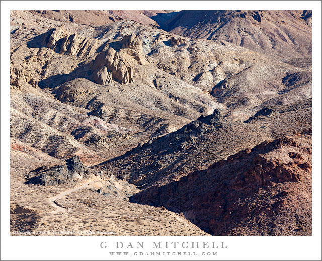
The relative solitude extended to this day, on which I drove over the Amargosa Range via Titus Canyon Road, the rough back-country one-way route between the Amargosa Valley and Death Valley itself. I know this route fairly well, having been over it a number of times. I always start in the morning, and this trip was no exception – I was well out on to the route when the sun came up. Often I just take a few hours for the trip, stopping at a few key locations. But recently I have thought more about how I might photograph some of these places that I used to simply drive through, and on this visit I slowed way down and devoted almost the entire day to this area. The location in this photograph is an example of the sort of area that I might have just passed through in the past. Here the road traverses the upper reaches of a very large canyon that eventually spills out into Death Valley far below. The location from which I made the photograph marks the high point on the route, and I always stop there – but on some previous visits I have just regarded the terrain as being empty. It isn’t, and I’m learning to see it more clearly. Here the gravel road drops down from the previous ridge, winding through the rough and dry landscape to the bottom of the canyon and its dry stream bed before climbing steeply up to my camera position.

G Dan Mitchell is a California photographer and visual opportunist whose subjects include the Pacific coast, redwood forests, central California oak/grasslands, the Sierra Nevada, California deserts, urban landscapes, night photography, and more.
Blog | About | Flickr | Twitter | FacebookGoogle+ | 500px.com | LinkedIn | Email

Text, photographs, and other media are © Copyright G Dan Mitchell (or others when indicated) and are not in the public domain and may not be used on websites, blogs, or in other media without advance permission from G Dan Mitchell.

Titus Canyon Narrows

Titus Canyon Narrows

Titus Canyon Narrows. Death Valley National Park, California. December 11, 2013. © Copyright 2013 G Dan Mitchell – all rights reserved.

Titus Canyon road passes through the Narrows as light reflects down from canyon walls high above

Titus Canyon road is a well-known “attraction” in Death Valley National Park, traveling from the eastern park boundary in the Amargosa Valley near the town of Beatty, Nevada over the Grapevine Mountains and then down to Death Valley itself. It is also known as a fairly rough road, subject to washouts and closures after storms – not a true four-wheel-drive road, but certainly not for the faint of heart of those who are not accustomed to rough desert and mountain driving. (Many chose to forgo the long drive and instead hike into the canyon from its mouth, from which the spectacular “narrows” section is easily accessible.)

I have been getting to better know the country through which this road passes as I’ve driven it many times during the past decade or so. More recently I have been slowing down and taking nearly the full day to drive its length – and in doing so I am able to see and photograph things that I used to miss. Oddly, since it is often regarded as the main attraction of the route, I’ve often found it very difficult to photograph the narrows section near the end of the road just before it spills out at the top of a giant alluvial fan along the edge of Death Valley. Perhaps it is the predominantly gray color of the rocks – once you’ve photographed the canyons of the Southwest, California rock just looks so drab! This time I think I passed through the narrows section at what must have been just about the ideal time of day and season, and light hitting upper canyon walls was reflecting down into the bottom of the canyon and creating some interesting, albeit subtle, colors and soft reflections on the rocks.

G Dan Mitchell is a California photographer and visual opportunist whose subjects include the Pacific coast, redwood forests, central California oak/grasslands, the Sierra Nevada, California deserts, urban landscapes, night photography, and more.
Blog | About | Flickr | Twitter | FacebookGoogle+ | 500px.com | LinkedIn | Email

Text, photographs, and other media are © Copyright G Dan Mitchell (or others when indicated) and are not in the public domain and may not be used on websites, blogs, or in other media without advance permission from G Dan Mitchell.

Cottonwood Trees, Reflection

Cottonwood Trees, Reflection

Cottonwood Trees, Reflection. Yosemite Valley, California. October 30, 2013. © Copyright 2013 G Dan Mitchell – all rights reserved.

Cottonwood trees with fall foliage reflected in the Merced River

Believe it or not, this is the mighty Merced River, draining a vast section of the Yosemite High Sierra that extends all the way to the highest peaks of this section of the Sierra crest. On this late October afternoon, on a dry day during a dry month at the end of the second of two drought years in the Sierra, the river felt in many ways more like a creek. The water moved slowly, gently rippling over rocks in the shallow sections and pooling in the deeper areas where the movement of the water was almost invisible. The contrast between this scene and what the river can do is apparent when your realize that these trees could be standing in very deep water during the peak runoff floods of a wet year.

I had wandered out to this relatively accessible location in the afternoon, drawn by the golden cottonwood trees that were approaching their peak autumn color, the brilliant fall backlight from the low afternoon sun down the Valley to the west, the shadowed granite face beyond, and the possibility of using the river as an element in photographs. I was apparently not the only person with this idea, and when I arrived I found perhaps a half-dozen painters occupying strategic spots on gravel bars, the beach, and along the banks. I made some photographs that included these artists, but I also contrived to exclude them from some of the compositions, including this one that brought together all of those elements that I came here to find.

G Dan Mitchell is a California photographer and visual opportunist whose subjects include the Pacific coast, redwood forests, central California oak/grasslands, the Sierra Nevada, California deserts, urban landscapes, night photography, and more.
Blog | About | Flickr | Twitter | FacebookGoogle+ | 500px.com | LinkedIn | Email

Text, photographs, and other media are © Copyright G Dan Mitchell (or others when indicated) and are not in the public domain and may not be used on websites, blogs, or in other media without advance permission from G Dan Mitchell.

High Country Desert Canyon

High Country Desert Canyon

High Country Desert Canyon. Death Valley National Park, California. April 6, 2013. © Copyright 2013 G Dan Mitchell – all rights reserved.

A back-country gravel road twists through the upper reaches of a colorful mountain canyon, Death Valley National Park

The gravel back-country road might be hard to spot in this photograph, but if you look closely near the lower right you may see it twisting around a bend before crossing the canyon behind the rocky prominence at the bottom of the frame. The road begins in desert sagebrush country, then rises to cross the Amargosa Range before descending, sometimes precipitously, down toward the main Death Valley.

Some things about photographing this subject are easy and obvious, but others are a bit challenging and require some attention and then some resistance to trying to turn the scene into something it isn’t. What is easy about this subject? I am endlessly fascinated by winding canyons with overlapping ridges that descend toward the bottom of the canyon, creating a back and forth weave of form. Here the canyon winds from right (at the top) to left to right to left to right to left and, finally, back to the left. And the colors and textures are remarkable, ranging from the very dark rocks at the bottom, through the much lighter slopes right above to the rather reddish rock in the far, upper portion of the canyon. What is hard about it? In many ways, it is easy to pass right through such an area and overlook what it offers, since there really is not single, central, and iconic “thing” to focus the attention. Instead, I almost have to remind myself to slow down, to stop, and to just look… and finally the way to photograph such subjects begins to reveal itself. In addition, because the color palette of this land is so subtle, including mostly pastel shades that subtly contrast with one another, it is important, I think, to resist the ever-present temptation to hype it up into something it isn’t.

G Dan Mitchell is a California photographer and visual opportunist whose subjects include the Pacific coast, redwood forests, central California oak/grasslands, the Sierra Nevada, California deserts, urban landscapes, night photography, and more.
Blog | About | Flickr | Twitter | FacebookGoogle+ | 500px.com | LinkedIn | Email

Text, photographs, and other media are © Copyright G Dan Mitchell (or others when indicated) and are not in the public domain and may not be used on websites, blogs, or in other media without advance permission from G Dan Mitchell.