Tag Archives: layers

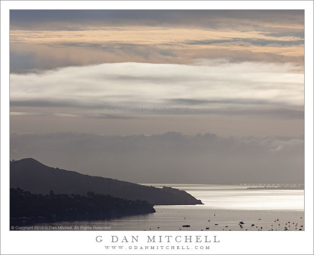
Morning Clouds, Angel Island, San Francisco Bay

Morning Clouds, Angel Island, San Francisco Bay - Light shining through layers of morning clouds over San Francisco Bay silhouettes the hills of Angel Island near Richardson Bay.
Light shining through layers of morning clouds over San Francisco Bay silhouettes the hills of Angel Island near Richardson Bay.

Morning Clouds, Angel Island, San Francisco Bay. Marin County, California. March 10, 2012. © Copyright 2012 G Dan Mitchell – all rights reserved.

Light shining through layers of morning clouds over San Francisco Bay silhouettes the hills of Angel Island near Richardson Bay.

I can be a bit of a creature of habit when it comes to shooting in certain locations that I’m very familiar with. But the habit isn’t so much shooting the same thing – though that can be part of it – as it is being attentive to how the familiar thing might present itself in ways I have not previously seen. This photograph is a case in point.

I was on my way to a location north of the Golden Gate where I frequently photograph, so I know the route well and have a routine that I frequently follow – it involves where I’m heading, what time I plan to get there, and the route I typically follow. Along the way there are several places where I almost always pause long enough to look around and see if a familiar scene might look different. At a location where my route follows a short ridge line, I often stop and look back across Richardson Bay towards Angel Island and, beyond that, the waterfront of Oakland and then the East Bay hills. On this recent morning, a weak weather front was washing out as it arrived in the Bay Area and, as a result, there were many layers of clouds stacked up to the east. While the sun was able to shine through and light the surface of San Francisco Bay beyond the boats anchored in Richardson Bay, there was haze in the atmosphere that obscured details even on relatively close Angel Island, and in the sky above and beyond there were layers of fog, lower clouds, and the highest clouds of the weather front.

G Dan Mitchell is a California photographer whose subjects include the Pacific coast, redwood forests, central California oak/grasslands, the Sierra Nevada, California deserts, urban landscapes, night photography, and more.
Blog | About | Flickr | Twitter | FacebookGoogle+ | 500px.com | LinkedIn | Email

Text, photographs, and other media are © Copyright G Dan Mitchell (or others when indicated) and are not in the public domain and may not be used on websites, blogs, or in other media without advance permission from G Dan Mitchell.

Corn Lily Leaves, Autumn

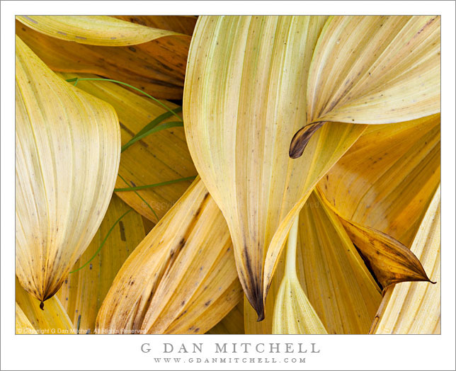
Corn Lily Leaves, Autumn

Corn Lily Leaves, Autumn. Yosemite National Park, California. September 18, 2011. © Copyright 2011 G Dan Mitchell – all rights reserved.

Corn lily plants take on autumn colors in the Sierra Nevada, Yosemite National Park.

The corn lily plants are among my favorite markers of the passage of the short high Sierra summer season. When the high country first opens and water is everywhere, the first shoots look almost like unhusked ears of corn as they come up in wet areas. (I don’t think this is where the plant gets its name – more on that in a moment.) They quickly grow to several feet tall, clustered in thick bunches, as the mosquito season arrives – and at this time they are incredibly lush and green. At this time they are also a favorite subject for photographers. A few seem to sprout much taller than others and produce clusters of white flowers. Then as August wears on and the soil begins to dry the plants also begin to lose their lush quality and brown areas appear and perhaps some spots and holes appear in the leaves. Often by the end of the month I can find some that are starting to turn one of several shades: golden-yellow, tan, or very dark brown verging on black. By mid September few healthy looking plants remain and the stalks (which look very much like corn stalks) begin to fall over to the ground.

It hardly matters where this particular group of corn lily plants was growing, so I’ll just say that they were within a few minutes of our camp site. I can hardly ever pass up the opportunity to try to photograph this plant, no matter which stage of its life it is currently going through. These had fallen over and were rapidly losing what remained of their green color.

G Dan Mitchell Photography
About | Flickr | Twitter | FacebookGoogle+ | 500px.com | LinkedIn | Email

Text, photographs, and other media are © Copyright G Dan Mitchell (or others when indicated) and are not in the public domain and may not be used on websites, blogs, or in other media without advance permission from G Dan Mitchell.
(Basic EXIF data may be available by “mousing over” large images in posts when this page is viewed on the web. Leave a comment if you want to know more.)

From the Panamints to the Sierra, Evening

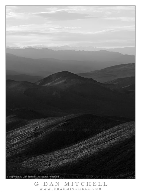
From the Panamints to the Sierra, Evening

From the Panamints to the Sierra, Evening. Death Valley National Park, California. March 30, 2011. © Copyright G Dan Mitchell – all rights reserved.

The Sierra Nevada in evening light as seen from Aguereberry Point in Death Valley National Park’s Panamint Range.

I made this photograph from Aguereberry Point shortly before sunset. Aguereberry Point is a lonely prominence over 6000′ above Death Valley, high in the Panamint Mountain range, a place of astonishing panoramic views – and often some significant winds. As I drove the gravel road to the point late in the afternoon I saw three or four other vehicles heading the other direction, but when I arrived at the point a bit more than an hour before sunset no one else was there.

Having photographed here a few times previously, I am becoming more familiar with the challenges and the opportunities of shooting here. One of the challenges – as is the case in many spots in Death Valley – is that certain subjects seem to be “photographable” at very specific times and only for short intervals. One of the most interesting views from Aguereberry is southeast down into Trail Canyon and on to the lower slopes of Wildrose Peak beyond. This is wild, rugged, austere terrain. However, because it lies on the east side of this range the light changes quickly from a washed out blast of daytime sun to sudden deep shadows as the sun drops behind the higher ridges of the Panamints. (Trail Canyon is not seen in this photograph.)

Another challenge is that, impressive and overwhelming as the scale of this grand scene is, it can be difficult to pull interesting compositions out of it. I tend to work with longer lenses here, both to isolate smaller areas out of the huge landscape and to compress distance. In this photograph, the silhouetted crest of the highest part of the Sierra Nevada range is on the horizon, with the intervening ridges of the Panamint Range and others probably including the Inyo Mountains and the ridge just west of Panamint Valley.

And, since I tend towards those large and long lenses… wind is an issue! And on top of Aguereberry Point there is nothing to stop the often strong winds of Death Valley. On this evening the winds were howling, so I found a spot below some rocks where it was a bit less windy and then spent a lot time waiting for momentary lulls in the wind when I could make photographs.

G Dan Mitchell Photography | Flickr | Twitter | Facebook | Email
Text, photographs, and other media are © Copyright G Dan Mitchell (or others when indicated) and are not in the public domain and may not be used on websites, blogs, or in other media without advance permission from G Dan Mitchell.
Conway Summit Aspens, Autumn

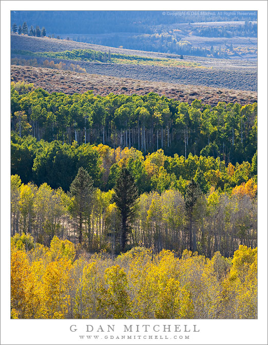
Conway Summit Aspens, Autumn

Conway Summit Aspens, Autumn. Sierra Nevada, California. October 10, 2010. © Copyright G Dan Mitchell – all rights reserved.

Layers of colorful autumn aspen groves lead up toward Dunderberg Meadow and Peak above Conway Summit, California.

I often plan my visits to this large aspen grove on the high point of highway 395 just north of Lee Vining for late afternoon, when the rows upon rows of large aspen groves are back-lit by the afternoon sun as it drops towards the crest of the Sierra Nevada near Dunderberg peak. Each grove tends to change color at a slightly different time, and each can take on a different shade ranging from green (in the case of those that change a bit later) to golden and red and orange. This year, in this area, the colors seem to tend more towards gold/yellow and less towards red/orange, but no matte what the shade they light up in this light.

I was extra lucky on this afternoon in that there were clouds. Talk to many Sierra photographers about the weather and you’ll discover that we are not so fond of the “perfect blue sky weather” that so many others love. Yes, it is “pleasant.” No, it is not necessarily visually interesting. It had been that sort of “perfect” weather for the first couple days of this visit to the “east side,” but in the middle of the afternoon on this day puffy clouds began to form over the crest, and their shadows added texture and brought out the shapes of hills and ridges beyond the aspens.

This photograph is not in the public domain and may not be used on websites, blogs, or in other media without advance permission from G Dan Mitchell.

G Dan Mitchell Photography | Twitter | Friendfeed | Facebook | Facebook Fan Page | Email