Tag Archives: light

Natural Bridge Canyon

Natural Bridge Canyon

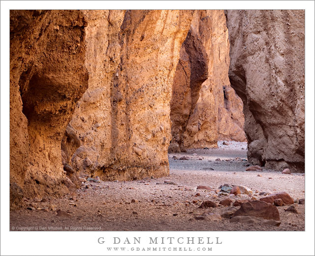
Natural Bridge Canyon. Death Valley National Park, California. March 27, 2010. © Copyright G Dan Mitchell – all rights reserved.

A gravel wash in the bottom of the narrow confines of Natural Bridge Canyon, Death Valley National Park.

These narrow canyons, of which there are a number of great examples in Death Valley, can provide some interesting photographic opportunities, but they also can pose some real challenges. Much of the rock in these places is, frankly, rather drab and of low contrast. However, at the right time of day and on a day with the right light and in the right parts of these canyons, the glowing light reflected down into the canyons from overhead rock walls can produce warm and diffused light and bring interesting colors to the place.

I made an unusual decision to use a very long focal length for this photograph – it was shot with a 100-400mm zoom at 330 mm. More typically I would probably tend to use wide angle focal lengths in the confines of such a canyon. However, because I wanted to juxtapose the different colors and shapes of the sections of canyon wall along the narrow and twisting wash, I chose the long lens to compress the distance. Although I think the photograph creates a feeling that I’m positioned very close to the foreground rocks and the darker bit of canyon wall on the left, I was actually quite a distance back from this spot.

G Dan Mitchell Photography
About | Flickr | Twitter | Facebook | Google+ | 500px.com | LinkedIn | Email

Text, photographs, and other media are © Copyright G Dan Mitchell (or others when indicated) and are not in the public domain and may not be used on websites, blogs, or in other media without advance permission from G Dan Mitchell.

(Basic EXIF data may be available by “mousing over” large images in posts. Leave a comment if you want to know more.)
Winter Evening, Big Sur Coastline

Winter Evening, Big Sur Coastline

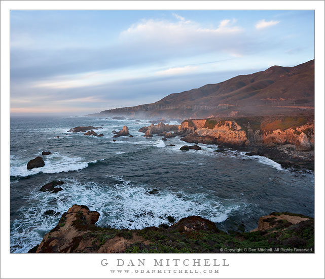
Winter Evening, Big Sur Coastline. Soberanes, Big Sur, California. January 2. 2010. © Copyright G Dan Mitchell – all rights reserved.

Last light of a winter evening shines on a shoreline bluff along the Big Sur coastline.

As the very end of 2010 approaches, here is a photograph from the very beginning of 2010, made back on January 2. It very similar to a photograph of this scene I posted back then, but it is not the same photograph, and I know like this one at least as much as the earlier selection. (And I feel justified in using two photos from the shoot after the case of poison oak rash I picked up making them!)

As I recall, this was another of those evenings that first looked very promising, then turned gray as the sun dropped behind clouds over the ocean, but held out hope for a last moment of color as the setting sun dropped to the horizon and beneath the clouds. And, as sometimes happens, it actually worked! I had seen this spot before but not stopped to photograph it quite this way. As I passed by while heading south earlier in the afternoon I had made a mental note about the possibilities for the scene, and when I turned back to the north to start my drive home I had decided to stop here. The scene is impressive, with the coast curving inward and then back out the left where a creek comes down to the sea, and with bluffs, sea stacks, and higher hills beyond. And on this evening the sky was full of pastel colors. So I stopped, unloaded the camera gear, and headed out (through the poison oak!) onto the bluff above the cove where I waited for light. And just at sunset a band of beautiful, warm, diffused light touched the bluff across the cove.

This photograph is not in the public domain and may not be used on websites, blogs, or in other media without advance permission from G Dan Mitchell.

G Dan Mitchell Photography
Flickr | Twitter | Facebook Fan Page | Facebook | Friendfeed | Email

San Francisco Skyline, Light Beams

San Francisco Skyline, Light Beams

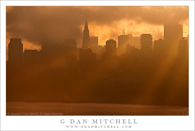
San Francisco Skyline, Light Beams. San Francisco, California. December 16, 2010. © Copyright G Dan Mitchell – all rights reserved.

Beams of light from brilliantly lit clouds send beams of light past downtown San Francisco buildings and toward the waterfront.

Anyone who knows San Francisco might be wondering about this light – and I wouldn’t blame them. These were really unusual conditions. Believe it or not, the photograph was made very early in the morning, perhaps a bit less than a half hour after sunrise. Which begs a couple of questions: why is the light coming from the right (west to southwest) at dawn? And, why does the light seem to be coming from such a high angle?

The light beams are not direct sunlight. The sun is actually far to the left of the frame and very low in the sky. Its direct light was blocked by intervening fog clouds. As the clouds moved from left to right, thinner areas in the cloud cover were struck from behind by the very low angle sunlight coming from the left and set aglow. It was the brilliant light from these areas of backlit clouds that cast the light through the mist and between buildings. What you cannot see in the still photograph is that as the clouds moved the beams of light slowly swept from right to left. From moment to moment the light beams would angle from right to left, then straight down, and then left to right.

Another amazing thing was that I appeared to be the only person out making photographs of this…

This photograph is not in the public domain and may not be used on websites, blogs, or in other media without advance permission from G Dan Mitchell.

G Dan Mitchell Photography
Flickr | Twitter | Facebook Fan Page | Facebook | Friendfeed | Email

McGee Canyon and Mount Morgan

McGee Canyon and Mount Morgan

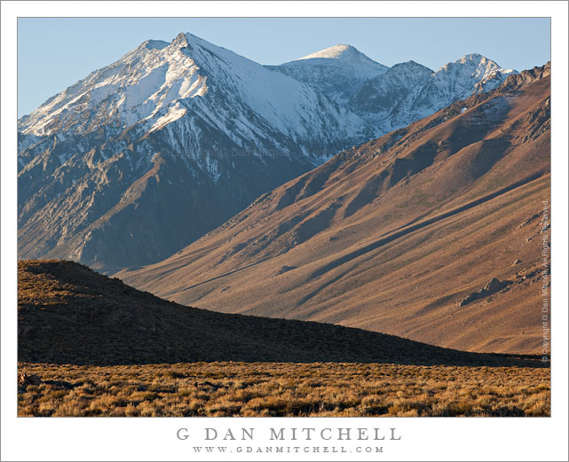
McGee Canyon and Mount Morgan. Owens Valley, California. October 10, 2010. © Copyright G Dan Mitchell – all rights reserved.

Snow crested Mount Morgan rises above McGee Canyon and the sagebrush-covered hills of Owens Valley in the eastern Sierra Nevada.

I’ve been traveling to the Sierra for many years. My first recollection of the range is a faint mental image of a shoreline park at Lake Tahoe when my family moved to California – I was four years old. My next memory is of staying at a small motel in El Portal next to the high water of the Merced River back in the days before the current mega-hotels were erected. One thing that all of my early Sierra experiences had in common is that I always approached the range from the west since I lived (and still live) in the San Francisco Bay Area. For the person whose orientation to the range is from the west, the Sierras are a range that begins almost imperceptibly in the Central Valley. Although you can see distant peaks from the Valley on clear days, it is hard to say where the range begins. As you head east you encounter some very small and rounded hills which gradually get larger. Eventually you are going up more than up and down as you  travel through oak and grass lands. At some point the road rises into forest, but the mountain tops are mostly rounded and forest covered. Keep going and a few rocky prominences begin to appear along the ridges and some distant granite peaks become visible. Only after a lot of driving do you find yourself in the higher reaches of the range, and this only in the few areas where roads cross from west to east. In most places you cannot even see the summit of the range close up from the west without walking a long ways.

It was only many years later that I first went over the summit of the range and saw it from the east side. The Sierra is (are?) completely different when approached this way. Instead of a long, gradual, and relatively gentle rise to high valleys and forests and meadows, the eastern escarpment of the Sierra rises abruptly – one might say violently – and directly, in most places, from the high desert sagebrush country of Owens Valley and similar places. This wall of peaks seems almost inaccessible, and I imagine that many people who only drive past on highway 395 must regard it that way.

This photograph was made from a spot just a mile or two east of highway 395, out an a gravel road that I know. I have photographed this shadowed foreground ridge and the peaks beyond in the past, so I had a fairly good idea of what I would find at this location before I made the photograph on an early October morning when fall storms had dusted the highest peaks with snow. I used a somewhat long lens and tight framing to emphasize the rise from the foreground desert to the very high peaks beyond.

This photograph is not in the public domain and may not be used on websites, blogs, or in other media without advance permission from G Dan Mitchell.

G Dan Mitchell Photography
Flickr | Twitter | Facebook Fan Page | Facebook | Friendfeed | Email