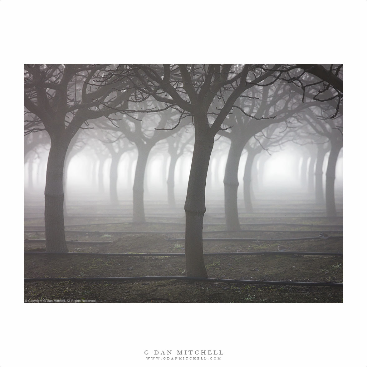
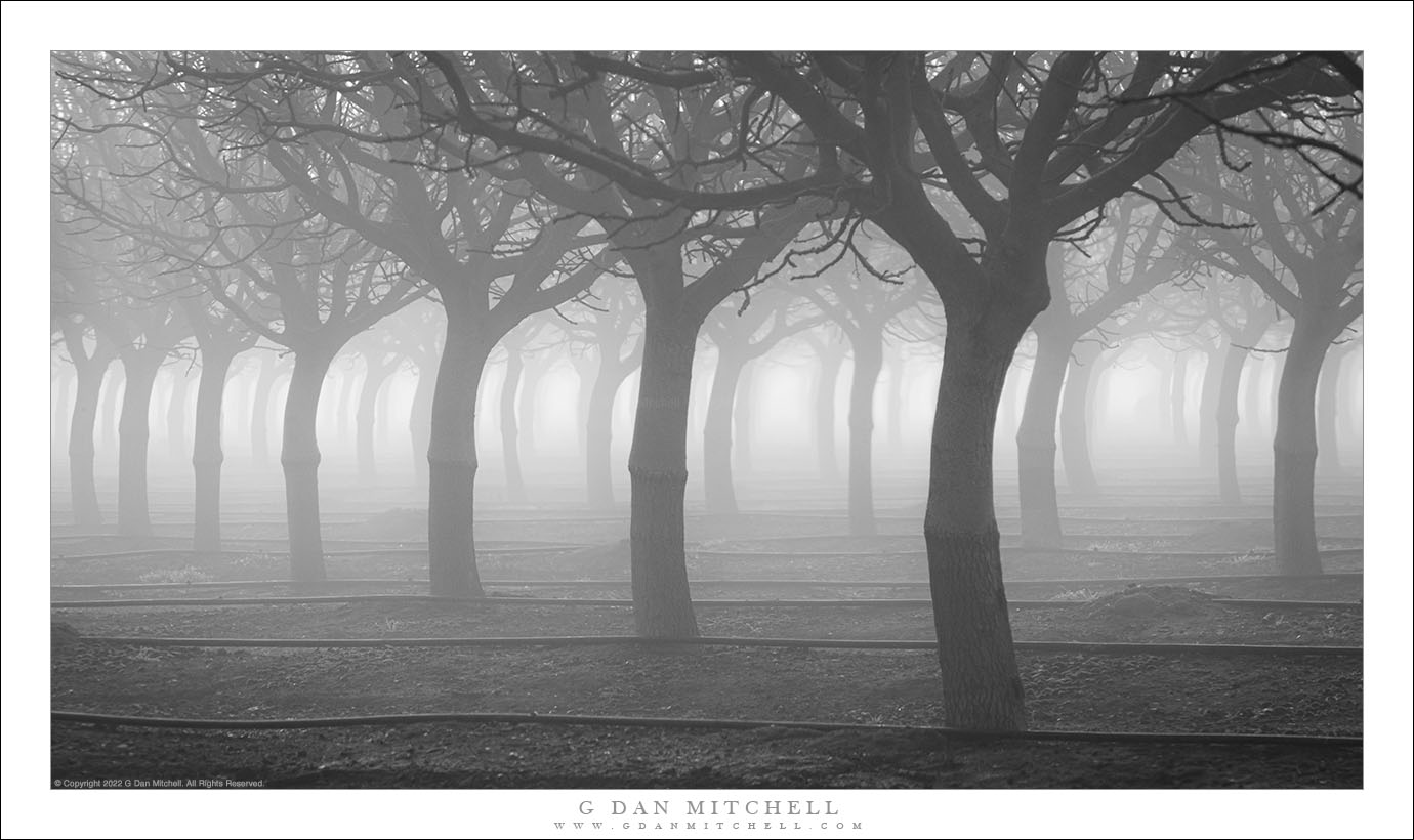
Tag Archives: orchard

Orchard, Fog

Orchard, Fog
Thick winter tule fog spreads through a Central Valley orchard.

Orchard, Fog. © Copyright 2022 G Dan Mitchell – all rights reserved.

Thick winter tule fog spreads through a Central Valley orchard.

The primary goal of my visit to the Pacific Flyway on this early-January day was to photograph migratory birds in the tule fog. I regularly check the weather predictions at this time of year, since it is the time of “interesting weather,” and this can make all the difference when it comes to the photographic potential of a location. On the day before I made this photograph, my check revealed a very good chance for dense tule fog — the kind that sane drivers try to avoid but which attracts photographers. So I was up very early, ready to drive through the fog for the chance to photograph it.

Local conditions can vary a great deal on days like this. Out where I was photographing birds the sky was beginning to clear, but I still wanted fog. So I drove a ways in a direction where the sky seemed darker, and before long I was once again engulfed. I had this orchard in mind as drove, and when I got there I took a gravel side-road to a spot where I could see an uninterrupted expanse of tree silhouettes fading into the distant fog where the sun was trying to break through.


G Dan Mitchell is a California photographer and visual opportunist. His book, “California’s Fall Color: A Photographer’s Guide to Autumn in the Sierra” is available from Heyday Books, Amazon, and directly from G Dan Mitchell.

Blog | About | Flickr | FacebookEmail

Links to Articles, Sales and Licensing, my Sierra Nevada Fall Color book, Contact Information.

Scroll down to leave a comment or question. (Click this post’s title first if you are viewing on the home page.)


All media © Copyright G Dan Mitchell and others as indicated. Any use requires advance permission from G Dan Mitchell.

Sandstone Tower, Fruita District

Sandstone Tower, Fruita District

Sandstone Tower, Fruita District. Capitol Reef National Park, Utah. October 8, 2012. © Copyright 2012 G Dan Mitchell – all rights reserved.

A sandstone tower stands above the Fruita District orchards in early evening light, Capitol Reef National Park

These sandstone plateaus and mesas seem characteristic of this front-country area of Capitol Reef National Park, and they are perhaps the most striking visual icon of your approach to the park from the town of Torrey, Utah, to the west. The Fruita District is the most accessible area of the park, being right alongside the main east-west highway that passes through the park. It features some picturesque sites and sights that are enough to make almost anyone pull over and look, including the old orchards that apparently gave the area its name and the accessible petroglyphs on low cliffs that run along the road. (Although this portion of the park is quite accessible once you are out here and driving across Utah, most of the park is anything but easily accessible, and getting to other places within its boundaries can involve some very long drives on some fairly bad roads, plus some hiking. I’m fine with that! ;-)

I made this photograph late in the day, after we had done a bit of exploring along the main tourist route into the park, the largely paved road towards Capitol Gorge and other nearby points. Late in the day I happened to spot this little conjunction of creek and fall-color tree and green grass and red rock cliffs as we were about to leave the park.

G Dan Mitchell is a California photographer and visual opportunist whose subjects include the Pacific coast, redwood forests, central California oak/grasslands, the Sierra Nevada, California deserts, urban landscapes, night photography, and more.
Blog | About | Flickr | Twitter | FacebookGoogle+ | 500px.com | LinkedIn | Email

Text, photographs, and other media are © Copyright G Dan Mitchell (or others when indicated) and are not in the public domain and may not be used on websites, blogs, or in other media without advance permission from G Dan Mitchell.

Central Valley Sky, Winter

Central Valley Sky, Winter

Central Valley Sky, Winter. Great Central Valley, California. January 23, 2011. © Copyright G Dan Mitchell – all rights reserved.

Thin winter clouds drift above farmland, Central Valley, California.

Photographing these beautiful winter clouds above the California Central Valley near the Cosumnes River between Stockton and Sacramento involved a certain amount of luck. For the most part it had been an extremely foggy morning – so foggy that at a few points early in the day I simply couldn’t find anything to shoot. Eventually the light began to filter down through the tule fog and I had some good luck shooting further up the valley at the Cosumnes River Wildlife Preserve.

At a certain point as the fog begins to thin it goes through a phase that is not so photographically compelling. The very thick fog can be quite interesting, and the light can be very special just as the sun starts to force its way through the fog as it starts to clear. But they there is a period when it is sort of sunny and sort of foggy, and but perhaps lacks the best aspects of each of the two conditions. That is how it was at about the time I left the Preserve and started back down the valley on my drive home.

Much earlier in the morning I had visited this side road near a bend in the Cosumnes River, so I decided to try it again since it was only slightly out of my way on the return drive. I drove slowly all the way to the end of the side road – to where it runs into the levee at the river – and then turned around to start back. I saw lots and lots of waterfowl, including impressive sandhill cranes and beautiful white egrets, but they were all too far from the road or in areas that didn’t provide the right kind of background. Near these flooded fields I stopped to consider trying to photograph some of the birds, changed my mind, and instead decided to see what I could do with these buildings, the flooded fields, and the sky. It was my luck that this final stop coincided with the near clearing of the fog and the appearance overhead of these wonderful clouds.

G Dan Mitchell Photography | Flickr | Twitter | Facebook | Email
Text, photographs, and other media are © Copyright G Dan Mitchell (or others when indicated) and are not in the public domain and may not be used on websites, blogs, or in other media without advance permission from G Dan Mitchell.

Flooded Field and Farm Structures

Flooded Field and Farm Structures

Flooded Field and Farm Structures. Central Valley, California. January 23, 2011. © Copyright G Dan Mitchell – all rights reserved.

Agricultural facilities and Central Valley sky reflected in the surface of a flooded field.

This area turned out to be fun place to shoot. It is along a fairly nondescript road that branches off from Interstate 5 midway between Stockton and Sacramento and eventually dead-ends against a levee lining the Cosumnes River. I had been told that it is a good place to look for migratory birds – and, indeed, it is. Although it was hard to see them due to the very thick tule fog when I first arrived shortly after dawn, when I came back in the early afternoon the sky had cleared and the many fields, vineyards, and ponds along the road were filled with waterfowl.

I first saw this set of “structures” (silos? Being a “city boy,” I’m not certain of the right way to describe cylindrical storage facilities like this) as I drove out from Interstate 5 towards the river. They make for quite a striking sight – they are quite large, they are tall and the tower above is even taller, the brick colored roofs stand out against the other colors, and they are reflected in the still water of surrounding ponds. It was on my way back past them that I saw the view over this pond. I had just stopped to make another photograph of the ponds and I thought I was finished for the day – my thoughts were getting back to the highway and heading home. But I decided to walk down to a levee that let me place the structures and their reflections across the water and surround the image of the building and the thin horizon line with sky above and below.

G Dan Mitchell Photography | Flickr | Twitter | Facebook | Email
Text, photographs, and other media are © Copyright G Dan Mitchell (or others when indicated) and are not in the public domain and may not be used on websites, blogs, or in other media without advance permission from G Dan Mitchell.