Tag Archives: rhyolite

Cook Bank Ruins, Rhyolite

Cook Bank Ruins, Rhyolite - The ruins of the Cook Bank in the ghost town of Rhyolite, Nevada, with barren desert hills under a pre-sunrise sky.
The ruins of the Cook Bank in the ghost town of Rhyolite, Nevada, with barren desert hills under a pre-sunrise sky.

Cook Bank Ruins, Rhyolite. Rhyolite, Nevada. January 3, 2012. © Copyright 2012 G Dan Mitchell – all rights reserved.

The ruins of the Cook Bank in the ghost town of Rhyolite, Nevada, with barren desert hills under a pre-sunrise sky.

This was the closest to the winter solstice that I’ve visited Rhyolite, so I shouldn’t have been surprised by several things. First, the sun came up not only later, but also a bit further south along the horizon – and the light that would usually strike these ruins at sunrise was blocked for a while by a large hill that sits next to the town. Second, it was cold! Third, no one else was there at sunrise! This is a bit unusual since in the Death Valley high season (which arrives a bit later in the year), Rhyolite can be a pretty popular place… for a ghost town… in the middle of the desert… in Nevada. :-)

Because I have photographed here several times before and for the reasons mentioned above, I took a bit of a different approach to photographing the place this time. The winter light, some high clouds, and the different point along the horizon of the sun rise meant that the light was quite different from what I’ve occasionally had to work with in the past. At first I was a bit disappointed to realize that the direct dawn light was not going to strike the old Cook Bank and other nearby buildings. But when some clouds to the east obscured the direct light and high, thin overhead clouds begin to pick up color and fill in the shadows, I saw that other interesting lighting was going to make up for it. At the moment that I made this photograph, those clouds to the east (right) of my position beautifully softened what might otherwise have been some stark and harsh light on the pinnacles beyond the town. They also created an unusual and beautiful quality of light for a few moments – a reddish-pink quality from the light reflected from the clouds but with a few soft quality.

I decided to shoot from a distance with a long lens so as to control the position of the ruins against the background hills, and the longer focal length makes these hills more prominent than they would be if I shot the building with a shorter focal length from a closer position. This also allowed me to more carefully eliminate some distracting elements that invariably appear at old sites like this. (The first times I visited, access to most of the ruins was quite unimpeded. Now fences have been erected around some of them. Part of me regrets the loss of access, but the greater part of me understands that this will allow these buildings to be around longer so that more people will get to see them. I stayed behind the fences.) If you look around on the web a bit, you can find some wonderful old photographs of this town when it was a bustling place with thousands of residents, and when the Cook Bank was a very impressive and modern-for-the-time building.

G Dan Mitchell is a California photographer whose subjects include the Pacific coast, redwood forests, central California oak/grasslands, the Sierra Nevada, California deserts, urban landscapes, night photography, and more.
Blog | About | Flickr | Twitter | FacebookGoogle+ | 500px.com | LinkedIn | Email

Text, photographs, and other media are © Copyright G Dan Mitchell (or others when indicated) and are not in the public domain and may not be used on websites, blogs, or in other media without advance permission from G Dan Mitchell.

Pre-Dawn Sky, Amargosa Range

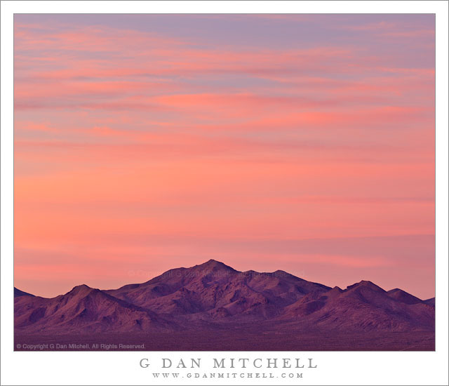
Pre-Dawn Sky, Amargosa Range - Sky above the Amargosa Range in pre-dawn light, Death Valley National Park, photographed from Rhyolite, Nevada.
Sky above the Amargosa Range in pre-dawn light, Death Valley National Park, photographed from Rhyolite, Nevada.

Pre-Dawn Sky, Amargosa Range. Death Valley National Park, California. January 4, 2012. © Copyright 2012 G Dan Mitchell – all rights reserved.

Sky above the Amargosa Range in pre-dawn light, Death Valley National Park.

I usually cannot resist the opportunity to photograph the ghost town of Rhyolite, Nevada when I’m in Death Valley. I especially like shooting there in the morning. I usually arrive before dawn since the pre-dawn light can create some wonderful effects on the ruins of the town’s buildings, especially if a few thin clouds and the right atmospheric conditions create some interesting light colors. So on this year’s early January trip I devoted one early morning to this subject.

As per my plan, I arrived at Rhyolite a few minutes before the good light started – it was very cold and no one else was there. In fact, I had the place to myself for the first half hour or so of my photography. I never know exactly what to expect when it comes to the dawn light. If things work out just right, and especially a bit later in the year, thin pre-dawn clouds will light up and color the light on the old town. That didn’t happen on this morning. First, I discovered that in the heart of winter, when the sun comes up a bit further south, a mountain right next to the town blocks the first light and it doesn’t strike the best ruins (such as the school and Cook Bank) until a bit later. In addition, on this morning clouds above the horizon blocked the light just a bit more than I would have liked. However… to the west and over the Amargosa Range things were rapidly becoming a lot more investing. This range was open to the light from the pre-dawn sky in the east, and high thin clouds began to pick up that colorful light that I had hoped might appear over the town. I put a long lens on the camera, moved to a position where I could get a fairly unobstructed view to the west, and made a series of exposures of this simple composition that allowed me to include a large section of the colorful sky.

G Dan Mitchell is a California photographer whose subjects include the Pacific coast, redwood forests, central California oak/grasslands, the Sierra Nevada, California deserts, urban landscapes, night photography, and more.
Blog | About | Flickr | Twitter | FacebookGoogle+ | 500px.com | LinkedIn | Email

Text, photographs, and other media are © Copyright G Dan Mitchell (or others when indicated) and are not in the public domain and may not be used on websites, blogs, or in other media without advance permission from G Dan Mitchell.
Schoolhouse Ruins, Rhyolite

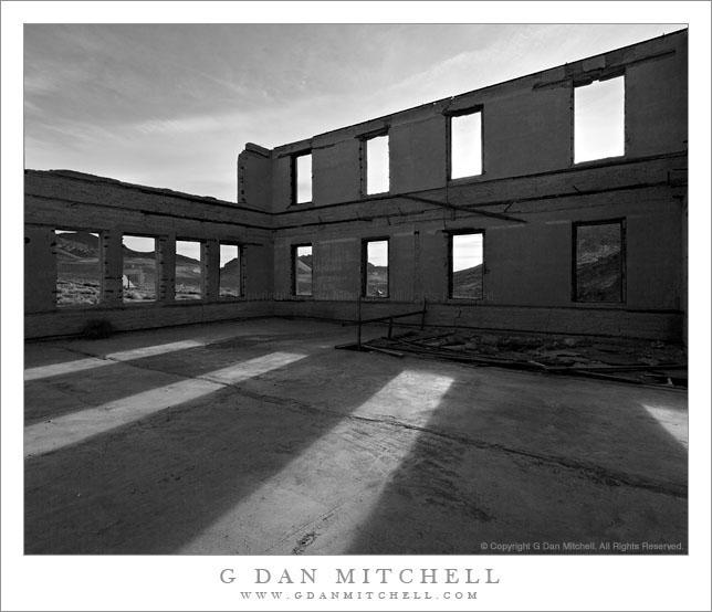
Schoolhouse Ruins, Rhyolite

Schoolhouse Ruins, Rhyolite. Rhyolite, Nevada. April 1, 2009 © Copyright 2009 G Dan Mitchell – all rights reserved.

Morning sunlight shine through the window frames of the ruins of the abandoned schoolhouse in the ghost town of Rhyolite Nevada, near Death Valley National Park.

The ghost town of Rhyolite, Nevada is located just east of the boundary of Death Valley National Park, along the edge of the Amargosa Valley, and not far from Beatty, Nevada, which itself is close to the Nevada Test Site. Put all of that together and you have the potential for a bit of a spooky place!

Rhyolite was a short-lived mining town in the early 1900s, when it apparently was home to thousands of people who streamed to this forsaken landscape to find silver. The town was eventually abandoned – although some mining still takes place in the area – but a good number of the larger buildings are still there, in various states of decay. An old train station that looks pretty fancy is fenced off to keep us out, but you can walk (respectfully and carefully!) among many other old structures including the old school house that is the subject of this photograph.

I’ve been out here a number of times and dawn is my favorite time to photograph here. The light makes it to many of the old ruins very shortly after actual sunrise, and there is a moment of often beautiful light at this time. From Rhyolite the hills inside Death Valley National Park are visible to the west and above the nearer hills you can see Telescope Peak, the highest point in the park at over 11,000′ elevation.

The school (like a few of the other ruins) looks like it must have been a very large and robust structure. Even though the roof and the second floor are gone, almost all of the exterior walls still stand and don’t show any immediate signs of incipient collapse. On this morning I made a series of photographs from just inside one of the “doorways” of the school with a wide-angle lens. I selected and shared a few of them back in 2009, but I recently went back to my original raw files and decided to try this one in black and white.

G Dan Mitchell Photography
About | Flickr | Twitter | FacebookGoogle+ | 500px.com | LinkedIn | Email

Text, photographs, and other media are © Copyright G Dan Mitchell (or others when indicated) and are not in the public domain and may not be used on websites, blogs, or in other media without advance permission from G Dan Mitchell.
(Basic EXIF data may be available by “mousing over” large images in posts when this page is viewed on the web. Leave a comment if you want to know more.)

Volcanic Ridge, First Light

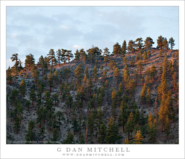
Volcanic Ridge, First Light

Volcanic Ridge, First Light. Mono County, California. © Copyright G Dan Mitchell – all rights reserved.

Dawn light illuminates the Jeffrey pine covered ridge of a volcanic dome in the Mono Craters complex, California.

I have a favorite personal spot where I often stop on my way to photograph at South Tufa at Mono Lake. It is spot that you would likely pass right by since, save for a bit of a panoramic view, there is nothing immediately impressive about it, and because you would probably be on your way to someplace else, namely the formations at South Tufa.

On this late June morning I took a break from photographing in the Tuolumne/Tioga Pass area to shoot a bit around Mono Lake, where I had it in mind to shoot certain high desert subjects that I’ve worked on in the past. As I shot those other subjects I’ve often looked up at this particular ridge, been impressed by it, and wondered how to make a photograph of it. When I pulled up at this spot I first intended to shoot a scene that appears to the west, but it turned out to not be quite what I imagined it might be on this morning. Ah, well – that happens! So I turned my camera in a different direction and photographed a somewhat different subject as dawn approached with some very interesting clouds in the sky to the east. As I worked on this I kept glancing up at this volcanic ridge, thinking that the clouds behind it might silhouette the trees along the skyline… but still finding the light too flat and boring. I actually made a photo or two, but wasn’t enthusiastic about it. I turned back to the other subject. A few minutes later I looked back up at this ridge and saw that the first light of early morning sun was glancing across the ridge and lighting up the Jeffrey pines that grow on its slopes. I quickly pivoted around and made a few exposures of the scene in the “good light.”

This photograph is not in the public domain and may not be used on websites, blogs, or in other media without advance permission from G Dan Mitchell.

G Dan Mitchell Photography | Twitter | Friendfeed | Facebook | Facebook Fan Page | Email

Technical Data:
Canon EOS 5D Mark II
Canon EF 70-200mm f/4 L USM at 168mm
ISO 100, f/8, 1/15 second

keywords: jeffrey, pine, forest, mono, county, craters, northwest, coullee, upper, dome, ridge, skyline, dawn, light, morning, early, sky, clouds, cinder, pumice, rhyolite, scree, rock, volcanic, geology, landscape, scenic, travel, california, usa, north america, mountain, hill, stock