Tag Archives: road

Turnstile Shadows

Turnstile Shadows
Turnstile Shadows

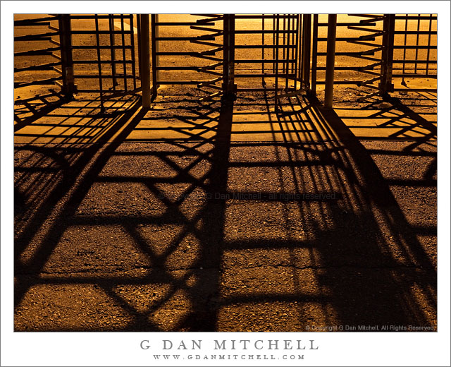
Turnstile Shadows. Mare Island Naval Ship Yard, California. February 12, 2011. © Copyright G Dan Mitchell – all rights reserved.

Shadows cast by sodium vapor lamps shining on old turnstiles at Mare Island Naval Ship Yard.

This old row of abandoned turnstiles stands at the entrance to an alley through which we almost always walk as we begin shooting in the core area of the historic Mare Island Naval Ship Yard near Vallejo, California. It seems odd to see the structure here since now one can just walk around them, but I suspect that this area must have been somewhat secure at times since military ships were built here.

This isn’t an easy subject to photograph. Several of us were talking about how we have struggled to find a composition built around the turnstiles. I have one other photograph that I made a few years ago that I think works pretty well. In that one I aimed a bit higher and let the metal structure pretty much fill the frame, and I also ended up making it a black and white image. (It was used as a cover for a book at one point.) But on this evening a few of us were staring at the turnstiles again and remarking that there must be more photographs in there… somewhere… but that we are still trying to find them.

I thought it might be interesting to make the long and complex patterns of the shadows fill most of the frame, so I moved back just a little and pointed the camera down so that just a portion of the turnstile structure appears at the top of the frame. This also helps with a couple of technical challenges: the bright lights beyond the structure create a tremendously large dynamic range in the scene, and it can be difficult to keep some distracting background elements (like a stop sign!) out of the image. The garish yellow/orange light is from a large sodium vapor lamp that sits above the intersection on the road in the background. That coloration is part of what made me choose to make the previous photograph of this subject black and white, but on this night I decided to go with the color.

The final image is a blend of two exposures. The shorter one was selected to avoid blowing out the brightest areas in the upper part of the frame, and the longer one let me keep a bit more detail in the shadowed asphalt foreground.

G Dan Mitchell Photography | Flickr | Twitter | Facebook | Email
Text, photographs, and other media are © Copyright G Dan Mitchell (or others when indicated) and are not in the public domain and may not be used on websites, blogs, or in other media without advance permission from G Dan Mitchell.

Confluence of Cascade and Tamarack Creeks

Confluence of Cascade and Tamarack Creeks

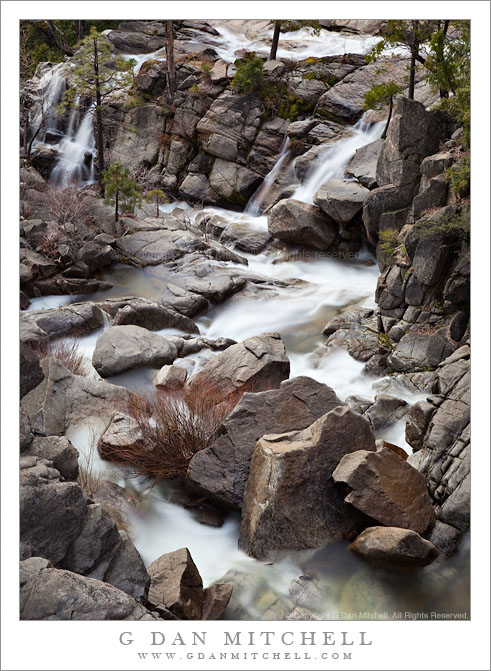
Confluence of Cascade and Tamarack Creeks. Yosemite National Park, California. January 16, 2011. © Copyright G Dan Mitchell – all rights reserved.

Long exposure in evening light of the boulder-strewn confluence of Cascade and Tamarack Creeks, Yosemite National Park.

Right below the bridge along the Crane Flat Road (often described as highway 120) route into Yosemite Valley, two wildly cascading creeks join together before their final descent to the bottom of the canyon where they join with the Merced River. Cascade Creek is probably the better known of the two since some spectacular sections of its descent are clearly visible right above the roadway. Tamarack Creek is easier to miss since you have to look carefully into the trees if you try to spot it from your car, or else get out of the car and look more closely. In the photograph, Cascade Creek flows away from the bottom of the frame, and Tamarack joins from the right in the upper portion of the frame.

I’ve always paid more attention to the section of Cascade Creek that is above the bridge. However, after recently having several opportunities to carefully (and admiringly) view Charlie Cramer’s stunning print of his “Cascade Creek, Spring, Yosemite”, I decided that I really needed to look off the other side of this bridge! (Charlie, I found your rocks. First, I’m even more impressed now that I realize how obscure and out of the way the subject of your photograph is. Second, how the heck did you position the camera over the side of the bridge to make that photograph!?) With that in mind, I visited this spot several times on this weekend trip to Yosemite and tried photographing it in different types of light.

This photograph is not in the public domain and may not be used on websites, blogs, or in other media without advance permission from G Dan Mitchell.
G Dan Mitchell Photography
FlickrTwitter (follow me) | Facebook (“Like” my page) | LinkedInEmail

Text, photographs, and other media are © Copyright G Dan Mitchell (or others when indicated) and are not in the public domain and may not be used on websites, blogs, or in other media without advance permission from G Dan Mitchell.

Titus Canyon Road

Titus Canyon Road
Titus Canyon Road

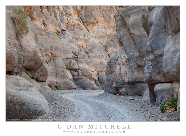
Titus Canyon Road. Death Valley National Park, California. March 28, 2010. © Copyright G Dan Mitchell – all rights reserved.

I made this photograph during midday hours after walking a ways up into the canyon from its mouth – the alternative to making the very long drive over the Grapevine Mountains from Amargosa Valley. (I have done the latter a few times, too.) While most Death Valley subjects tend to be appealing in the early morning or in the evening, many of the canyons can be at their best during the middle of the day, especially the very deep and narrow canyons like lower Titus Canyon. Here the canyon narrows down to the point that there is only room of a single gravel track, and twists and turns around rocky outcroppings. The light striking the upper canyon walls – out of the range of this photograph – reflects down into the canyon and produces soft, diffused illumination.

This photograph is not in the public domain and may not be used on websites, blogs, or in other media without advance permission from G Dan Mitchell.
G Dan Mitchell Photography
About | Flickr | Twitter | Facebook | Google+ | 500px.com | LinkedIn | Email

Text, photographs, and other media are © Copyright G Dan Mitchell (or others when indicated) and are not in the public domain and may not be used on websites, blogs, or in other media without advance permission from G Dan Mitchell.

(Basic EXIF data may be available by “mousing over” large images in posts. Leave a comment if you want to know more.)


Rugged Terrain, Lower Titus Canyon

Rugged Terrain, Lower Titus Canyon

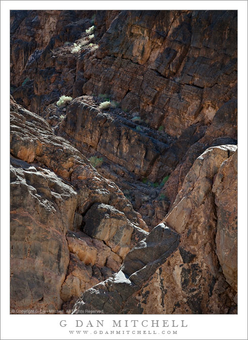
Rugged Terrain, Lower Titus Canyon. Death Valley National Park, California. March 28, 2010. © Copyright G Dan Mitchell – all rights reserved.

Details of the rugged cliffs and walls rising above lower Titus Canyon in Death Valley National Park.

Titus Canyon Road is one of the marvels of Death Valley National Park. It begins in high desert of Amargosa Valley near the town of Beatty and the ghost town of Rhyolite, winds over the summit of the Grapevine Mountains, drops precipitously into upper Titus Canyon, passes a number of historically interesting sites, passes through a very narrow and deep section in the lower canyon, and then suddenly emerges into the vastness of Death Valley.

In the lower section of the canyon, the wash becomes very narrow, passing through a twisty slot canyon and is, in places, barely wide enough for the one-lane gravel road. Here the walls of the canyon press tightly together and rise steeply for hundreds of feet. Some places are so deep that the sun rarely penetrates to the bottom.

Fortunately for the preservation of the canyon the road is horrible, at least if you are used to more civilized driving. It is a one-way road and the whole thing is gravel. Sections are in decent shape, but it other places the road passes over narrow and twisty sections next to precipitous drop-offs and then dives steeply into deep canyons. At times the route is closed after heavy rains or other conditions that make the route impassable.

Fortunately, the section that is perhaps the most impressive in many ways – the deep slot canyon near the bottom – is easily accessible by foot from Death Valley. After a short drive up to the canyon entrance on a gravel road to a parking area, you can enter the canyon on foot and walk up as far as you want. This photograph was made within the lower mile of the canyon during the late morning, when the light penetrates more deeply into the canyon and creates a glow on the canyon walls.

G Dan Mitchell Photography
About | Flickr | Twitter | Facebook | Google+ | 500px.com | LinkedIn | Email

Text, photographs, and other media are © Copyright G Dan Mitchell (or others when indicated) and are not in the public domain and may not be used on websites, blogs, or in other media without advance permission from G Dan Mitchell.

(Basic EXIF data may be available by “mousing over” large images in posts. Leave a comment if you want to know more.)