Tag Archives: rock

Sunset, Mt. Shuksan and Picture Lake

Sunset, Mt. Shuksan and Picture Lake

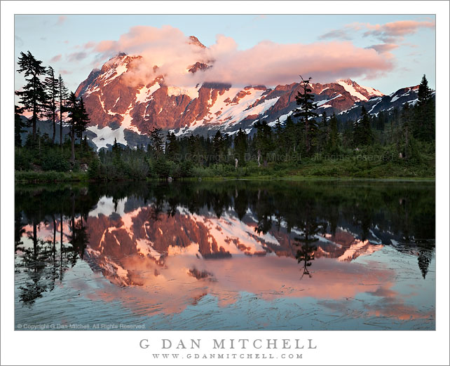
Sunset, Mt. Shuksan and Picture Lake. Mt. Baker-Snoqualmie National Forest, Washington. August 28, 2010. © Copyright G Dan Mitchell – all rights reserved.

Sunset on cloud-shrouded summit of Mt. Shuksan with Picture Lake in the foreground, Mt. Baker-Snoqualmie National Forest, Washington.

Icon alert! I understand that photographing Mt. Shuksan from this locale is, in the Pacific Northwest context, perhaps almost equivalent to photographing the Golden Gate Bridge from the Marin Headlands or photographing Yosemite Valley from Tunnel View. As a brand new photographer of Cascades Range subjects, I plead guilty to succumbing to this icon and photographing it. (I’m told that the only thing that this photograph needs in order to qualify for full “yet another photo of an icon” status would be to come back in a month and shoot it when the fall colors appear.)

My brother and I had been up higher photographing the Artist Point area for most of the afternoon, and he suggested that since we were here we might stop at Picture Lake on the way back down the mountain and see what might develop. I’m glad he did since, icon status aside, this really is a stunning and beautiful location and it was a quiet and beautiful evening. Several things made it special, I think. First, while the summit of Shuksan never fully cleared, the clouds shrouding the summit gave it a more dramatic aspect than might have been the case with an unobstructed view. Second, much to our surprise, we were not joined by a throng of other photographers. At first we were the only ones there, and later we only saw a few others in the area.

This was a technically challenging scene to photograph. The lake and foreground trees were in shadow at this point, though on the scene one could still see the details of the forest along and beyond the far shore. Yet the summit of Shuksan and the clouds were in full sun, and making this even more difficult, the red sunset light was extra intense. The eye can take all of this in without a problem as you move your focus from foreground to distant peak, but the camera is not as capable – and the dynamic range of the scene dramatically exceeds the capabilities of cameras. So, again, this photograph is a composite of three exposures manually blended in post to combine the best exposures of bright and saturated highlights with the best exposure of the dark forest along the shore of the lake.

Update on 9/29/10: I recently noticed that I had misidentified the lake in the photograph! I have corrected the post to call it by its correct name, Picture Lake.

This photograph is not in the public domain and may not be used on websites, blogs, or in other media without advance permission from G Dan Mitchell.

G Dan Mitchell Photography | Twitter | Friendfeed | Facebook | Facebook Fan Page | Email
Roots and Rocks

Roots and Rocks
Roots and Rocks

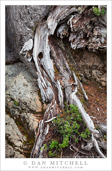
Roots and Rocks. Mt. Baker-Snoqualmie National Forest, Washington. August 28, 2010. © Copyright G Dan Mitchell – all rights reserved.

Weathered tree roots stretch across boulders at Mt. Baker-Snoqualmie National Forest, Washington.

I made this photograph at our first stop after we arrived at the Mt. Baker-Snoqualmie National Forest. (Technically, that isn’t quite true, since we had earlier stopped at the “ranger station” to ask some questions, but this was the first “real” stop for photography.) The road into this area twists and turns as it ascends toward and then past a ski area, and here we couldn’t help but pull over at a hairpin curve that provided a panoramic overlook to the valley below and the ridges to the east (?) of our position. Although the original reason for stopping was this dramatic view, I soon found nearby “intimate landscapes” to also be very interesting. While I often hike and climb long distances to find my photographs… for this one the tripod was on asphalt and the subject right next to the road.

On a technical note, for this photograph I used a lens that I’m increasingly fond of for photographing subjects like this one, the Canon EF 70-200mm f/4 L USM (link to B&H). I find it useful to be able to put a bit of distance between myself and subjects in which the entire image may include only a few square feet, and the ability to fine tune the composition with the zoom is very useful. Although I didn’t do it in this photography, working with a slightly longer focal length also lets me have the option of isolating the subject against an out of focus background. I have the non-IS version of the lens – because that was the only version available back when I got mine – though I would almost certainly get the IS version if I were to replace it.

This photograph is not in the public domain and may not be used on websites, blogs, or in other media without advance permission from G Dan Mitchell.

G Dan Mitchell Photography | Twitter | Friendfeed | Facebook | Facebook Fan Page | Email
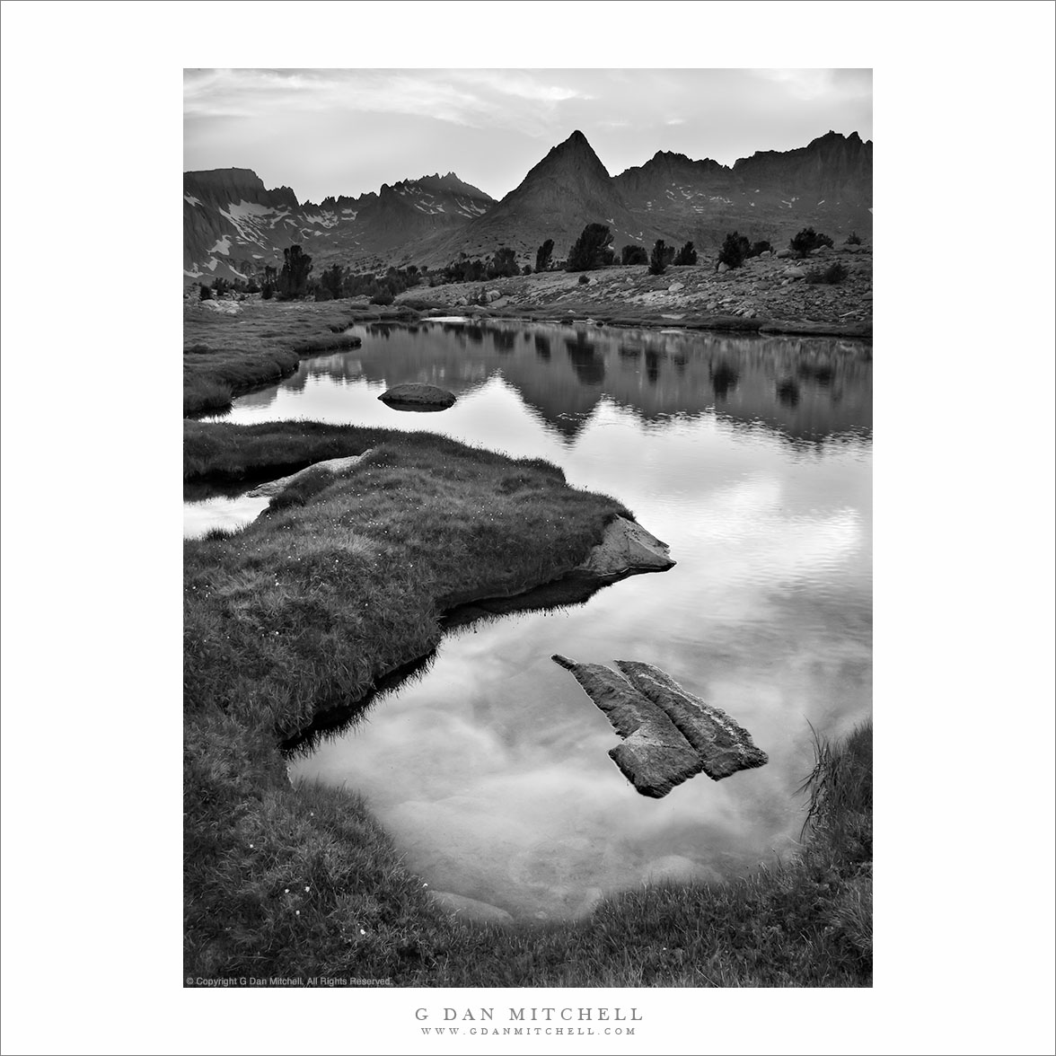
Evening, Unnamed Lake and the Great Western Divide

Evening, Unnamed Lake and the Great Western Divide
“Evening, Unnamed Lake and the Great Western Divide” — Evening sky over the Great Western Divide reflected in an unnamed alpine lake, Sequoia National Park, California.

I don’t know quite what to say about this area of the Sierra located just east of the Great Western Divide in the upper reaches of the Kern River drainage – I’ve been very close to this place on many previous trips, but I never quite managed to hop the intervening ridge, even though I’ve thought vaguely about visiting this area for decades and I once passed through the lower reaches of it, more or less by accident and completely unaware of what was just upstream.

A group of us traveled over Kearsarge Pass (11,700’+) and Forrester Pass (13, 200′) to arrive in the upper Kern River drainage at Tyndall Creek along the JMT. (I think the general area is also known as the “bighorn plateau.”) I’ve been here on several previous occasions while heading to or circumnavigating Mt. Whitney. While I’ve gone east (to exit over the very rough Shepherd Pass at 12,000′) I’ve not really explored the western and norther parts of this area. Our general plan on this trip was to rectify that, specifically by visiting remote Lake South America. WE arrived there after wandering up a mosquito-infested valley, climbing its headwall, and then dropping to a lake just below the saddle. We originally planned to stay here overnight, but the very barren and rocky surroundings didn’t attract us, so we decided to head on to the west and south.

After a bit of a walk on a somewhat rough trail (which got much rougher later on) we arrived at a series of timberline lakes overlooking the Great Western Divide, which towered above us to the west. There is much I could say about this area, but I’ll limit myself to a few comments… and not name the specific location we visited. We finally found a sandy camping spot between a few lakes and tarns – it was surrounded by stunning alpine views ranging from the lakes themselves and the surrounding rocky meadows and clumps of trees to the jagged and high peaks to our west. The next morning we followed a very faint trail down the canyon, passing almost continuously through astonishing scenery featuring intimate, granite-surrounded meadows and small lakes.

I must go back. It won’t be easy. I’ll want to carry a bit more photography gear than I carried on this trip, and I’ll want to stay a day or two longer. And the location is two to three days from the nearest trailheads, all of which take you over some very high passes.

NOTE: This post was lightly edited in August 2026. Sadly, I have not made it back to this location in the intervening years.


COMMENT OR QUESTION? Scroll down to the comment form.

See the Sales page for information about licensing and print sales.

G Dan Mitchell is a California photographer and visual opportunist. His book, “California’s Fall Color: A Photographer’s Guide to Autumn in the Sierra” (Heyday Books) is available directly from him.
Blog | Bluesky | Mastodon | Substack Notes | Flickr | Email

All media © Copyright G Dan Mitchell and others.


Natural Arch, Sierra Nevada

Natural Arch, Yosemite

Natural Arch, Sierra Nevada, California. July 23, 2010. © Copyright G Dan Mitchell – all rights reserved.

One of two known natural arches in this area stands high on a ridge.

Although I have visited this area for decades and know it quite well, this year was the first time I had taken notice of and actually visited this natural arch or bridge, supposedly one of two in this region. (The other is, from what I’ve heard, underwater!) I won’t say too much more about this feature since it seems to be pleasantly unburdened by tremendous waves of tourists at this point… If you know where it is, I urge you to do the same.

(To illustrate how important this is with a fragile feature such as this arch, after I posted this image somewhere else a person followed up with a photograph of some damned fool standing on the arch! This demonstrates a gross disregard for this beautiful feature – there are weaknesses in the rock at the ends of the arch, and taking risks with a feature like this one that took nature thousands of years to construct is the height of irresponsibility.)

This photograph is not in the public domain and may not be used on websites, blogs, or in other media without advance permission from G Dan Mitchell.

G Dan Mitchell Photography
About | Flickr | Twitter | Facebook | Google+ | 500px.com | LinkedIn | Email

Text, photographs, and other media are © Copyright G Dan Mitchell (or others when indicated) and are not in the public domain and may not be used on websites, blogs, or in other media without advance permission from G Dan Mitchell.

(Basic EXIF data is available by “mousing over” large images in blog posts. Leave a comment if you want to know more.)