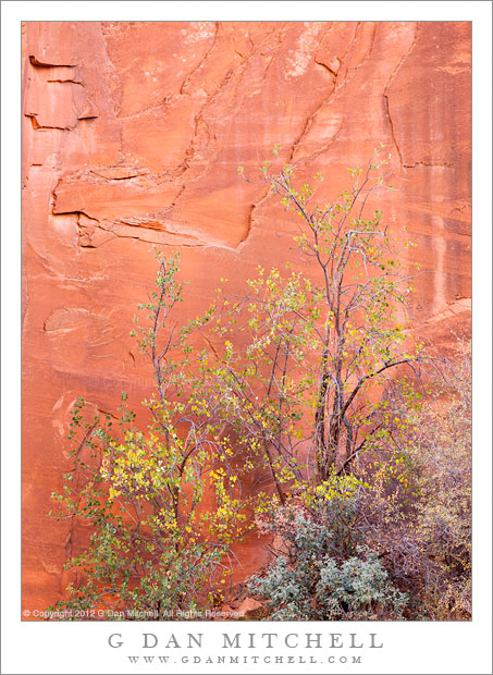
Brush including some autumn foliage stands against a bright red sandstone cliff, Capitol Reef National Park
This area was yet another surprise – though perhaps only because I’m a California guy still very much in the early stages of discovering the landscape of Utah. We had driven a long route down a good part of the length of Capitol Reef National Park, climbed over the higher portion of the north-south ridge, and were heading back to our lodgings some distance away. As we drove across this new (to us!) landscape we descended into a long, narrow canyon that had some of the most beautiful red rock walls I had yet seen.
Such canyons provide a wealth of photographic opportunities and require some slightly different thinking about timing and about light. In so many situations, we look for the “good light” at the edges of the day, in the very early morning and then again in the evening. However, in these canyons that is not the only good time to search of the light. At times that are later in the morning and earlier in the afternoon, the higher sun strikes the upper walls of such canyons and reflects beautiful light down into the canyon bottoms, like that may be colored by the rocks from which it reflects. In this spot it was not very bright, but the light was beautiful! Because we were “on our way” from one place to another we almost didn’t stop, if you can believe that!
G Dan Mitchell is a California photographer whose subjects include the Pacific coast, redwood forests, central California oak/grasslands, the Sierra Nevada, California deserts, urban landscapes, night photography, and more. Blog | About | Flickr | Twitter | Facebook | Google+ | 500px.com | LinkedIn | Email
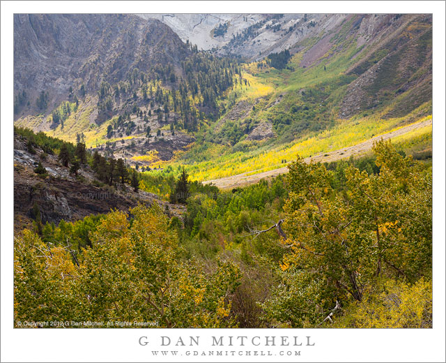
Early fall color comes to McGee Canyon in the eastern Sierra Nevada, California.
I’m going to use today’s post not only as the opportunity to share another daily photograph, but also to share some observations about the arrival of the fall aspen color season in the eastern Sierra Nevada range, where I spent a good part of the past week.
I made the photograph at the very end of a three-day backpack trip up into the McGee Creek drainage, where we settled in at a 10,000+” lake for a couple of nights to enjoy the late-season solitude. (Before starting the pack trip I had spent a couple of days in Tuolumne Meadows, and upcoming posts will concern that part of the trip.) McGee Canyon is an eastern Sierra “type” – a typical trailhead canyon that rises from the high desert, into forests, through increasing rugged and rocky country, and finally reaches the crest of the range at a pass. On this early afternoon we were fortunate to get a few clouds, moderating the intense sun and adding a bit of texture to the landscape. The photo was somewhat casual – still wearing my full pack, I shot hand-held.
About the onset of fall color… I have watched this transition carefully for a number of years. While I have learned a lot about how the process unfolds, I have also learned that many aspects of it defy precise prediction. Every September, those of us who chase eastern Sierra aspen color start to watch for signs that might provide clues about the nature of this season – the amount of snow during the previous winter, how late it remained before melting out, long-range weather forecasts, early color changes in many other plants that can show up even in late August, and more. But, truth be told, in the end every aspen season seems to hold surprises and defy out attempts to know in advance how it will play out. A season may start with early color up high, only to be interrupted by early storms. Or a season may start late and then move very quickly. Or poor early color in one part of the range may lower expectations… only to be followed by great low-elevation later on. Or there may be any number of other possible variations, too numerous to list.
All of this is my way of saying to take my observations with a suitable dose of salt. :-)
Several weeks ago I began to read the typical early September notes about “early color” here and there, especially in portions of the Rockies and some areas of the Southwest. I was intrigued, but not ready to believe it. I read and hear these reports of early color every season – and generally the correlation between what is written and what occurs in the actual event is weak.
This has been an odd summer season for me, for reasons I won’t go into here. As a result, I had not been to the Sierra since early July or so – a very large gap of time for me, since I rarely allow more that a couple of Sierra-free weeks to occur in the summer. I was not there at all during August – which is almost unheard of. I usually catch my first hint of oncoming autumn on one of those late-August visits. It is hard to put my finger on precisely what it is, but invariably (well, almost invariably, since it didn’t happen this year…) there will be a day when I sense “something” in the air that reminds me that summer will end very soon – whether it is a breeze, a quality of light, a change in the plants, I can never tell for sure. But I am sure when I experience it.
Soon there are more concrete signs. The golden-brown dried meadow areas start to expand, the wildflowers are harder to find, corn lily plants begin to turn golden-yellow, bilberry leaves turn dark red (and brilliant red when back-lit) and the leaves of willows near streams and lakes turn yellow. By mid-September all of this is typically underway, and at this point I start thinking about aspen color in earnest. Whether it is because we tend to go to different places to find our aspens or because we have experienced different seasonal variations, individuals will tell you to look for the aspen show to begin at somewhat varying times. I tend to look for real aspen color around the very beginning of October, and to expect a peak roughly a week into the month in the higher country. Except for watching for the odd tree with a branch full of yellow leaves, I don’t expect to seem much real color in September.
But… I just returned from a pack trip that was right in the middle of September… and I saw a significant amount of aspen color. As I drove over the Sierra crest on my way to the east side I was not expecting to see aspen color, and I did not see much. Despite the other sources of fall color, the aspens just east of Tioga Pass and down in Lee Vining Canyon were almost uniformly as green as I expected. When we arrived at our eastern Sierra trailhead, there were a few yellow leaves here and there, but nothing too out of the ordinary. However, a mile or two up the trail I was quite surprised to find large stands of aspens in which many trees were showing color – just a few leaves on some, but perhaps a quarter or a third of the tree in the most extreme cases. In my experience, this is unusually early – but at least a week and arguably perhaps a bit more. (Not all of the color in the photograph comes from aspens, by the way.)
What does this mean? I’m not sure. If I had a bit more time I would have investigated one or two other east-slope canyons to see what is going on elsewhere – it could be that this canyon is somehow out of sync with others. But I doubt it. All I’ll say is the following: Some aspen color is already beginning to appear in some areas of the eastern Sierra. While no one knows when the main show will arrive (or what it will look like), if I were making plans for a visit to the eastern Sierra to photograph aspen color, at this point I would lean toward going a little bit early rather than a little bit late. However, as always, realize that you cannot count on the timing or the quality of the display, and flexibility increases your odds of being there at a good moment.
More articles on Eastern Sierra aspen photography:
G Dan Mitchell is a California photographer whose subjects include the Pacific coast, redwood forests, central California oak/grasslands, the Sierra Nevada, California deserts, urban landscapes, night photography, and more. Blog | About | Flickr | Twitter | Facebook | Google+ | 500px.com | LinkedIn | Email
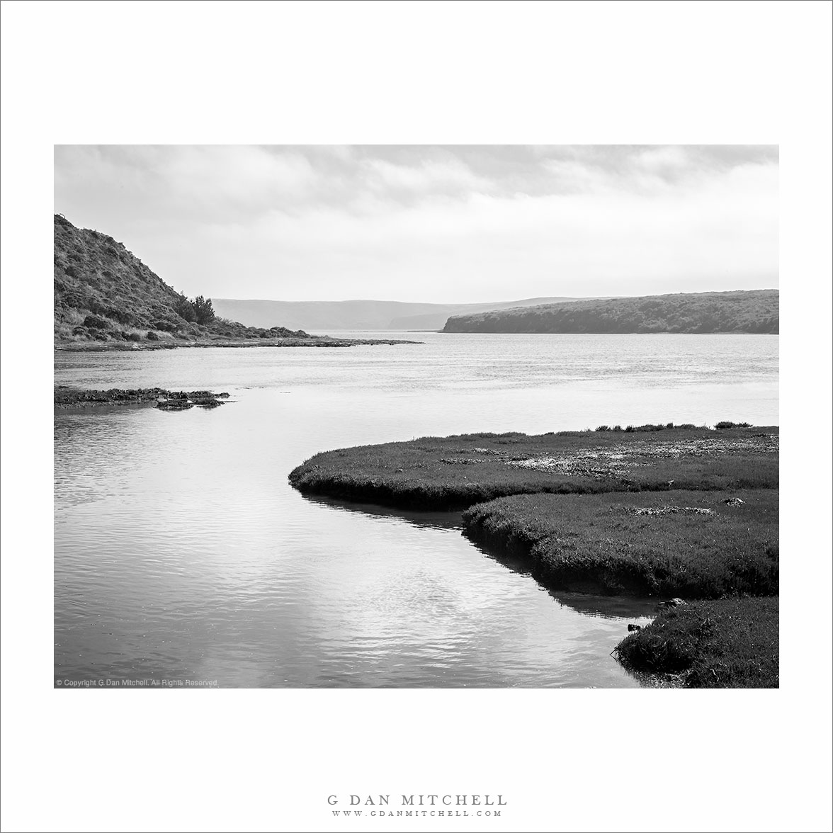
“Home Bay, Drakes Estero” — Fog rolls in over Drakes Estero beyond Home Bay, Point Reyes National Seashore
This quick late-July visit to Point Reyes was an opportunity to re-learn a few lessons about going out to make photographs. I drove up to San Francisco, where my wife was to be involved in a music performance — the plan being to drop her off and then drive on over the Golden Gate Bridge to Point Reyes. It is often cold and windy there, even in the summer, but this was a very warm period and it looked like the coast might be clear of fog. With this in mind, I planned to either visit the Limantour Beach or else hike out towards Drakes Bay.
I should have sensed that things were about to evolve in ways that I had not planned for when, during a brief stop at the Point Reyes visitor center, the rangers announced that the road to Limantour was closed since a fire had just started in the area! With that option gone, I figured that Drakes Bay would be my objective, and I had images of afternoon and evening light on this day of little or no fog. I drove on out to the Estero trailhead where it was, in fact, quite sunny, though a bit windy. I loaded up my camera pack with a few lenses and a tripod, and set out towards Drakes Head, thinking I might make it there for late afternoon light. Soon I saw the telltale puffs of incoming fog overhead, and I came around a bend in the trail to see that the fog had already moved in to the west and over Drakes Bay. Fortunately, iin most cases I would rather photograph in “interesting” weather than in supposed perfect blue sky weather.
At a point where the trail descended to cross a dike at the head of Home Bay, I saw this conjunction of near and far forms, with the distant bluffs under the incoming fog, so I stopped to make a few photographs before moving on. To make a potentially long story a bit shorter, the temperature quickly dropped and the wind picked up to levels that made photography increasingly difficult. I managed to work with one other scene that included a curving snag in front of the bay, but it was already becoming difficult to find a calm moment in the wind to click the shutter. I kept going, finally reaching the trail junction that heads off towards Drakes Head, only to realize that I would never get all the way out there in time to return before dark. Cutting the hike short after a bit more than an hour and a half of hiking, I began to retrace my steps back to the trailhead.
In the end, this is really the only photograph that I came away with – despite carrying that fully loaded camera pack out and back! But this reminded me of a first lesson, namely that it is worth the effort even if I only come back with a single shot that I like. This one, to me, evokes the relative isolation and quiet of this spot in the upper reaches of the calm waters of Drakes Bay, with the fog bank beginning to assemble across the distant bluffs. A second lesson is that sometimes on a photographic quest, it is OK to simply enjoy the surroundings. A practical photographer can remind himself or herself that scouting is a good thing, and that things not photographed this time may well be on a future visit. And a long-time hiker can – and did – remind himself that sometimes it is just fine to leave the camera in the pack and just enjoy the wind and the space.
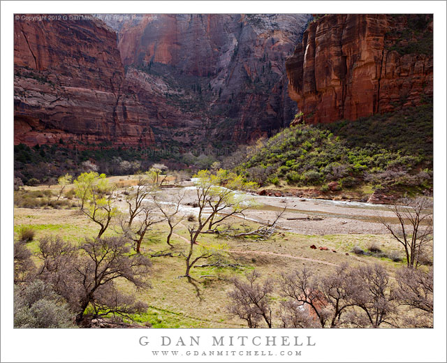
The Virgin River flows through Zion Canyon near Weeping Rock, Zion Canyon National Park, Utah.
On this morning we were back in Zion Canyon, following the Virgin River up the Valley to various locations. While it was still quite early we had walked up to the base of Weeping Rock, deep in the shaded area in the center of this photograph, and photographed there in the quiet shade. Then we moved a short distance up this part of the canyon where it makes a rather sharp series of turns and stopped an a place where there were visits up, down, and across the Virgin River and along the huge sandstone cliffs in all directions.
Looking around, I saw that there were some scattered clouds that were moving across the sky and alternative shading and lighting various portions of the landscape, and creating some dramatic effects, especially when the light came from behind the group of cottonwood trees along the banks of the river below me. The skeletal forms of the trees’ trunks were still clearly visible and, when the light was bright enough, they cast mirror-image shadows on the new grass below. The tops of the trees were fringed by new leaves, and these glowed brightly in the backlight coming from above the far cliffs above Weeping Rock. There was just enough haze in the air, amplified a bit by backlighting, to suggest the distance and massive size of the dark cliffs.
G Dan Mitchell is a California photographer whose subjects include the Pacific coast, redwood forests, central California oak/grasslands, the Sierra Nevada, California deserts, urban landscapes, night photography, and more. Blog | About | Flickr | Twitter | Facebook | Google+ | 500px.com | LinkedIn | Email

 G Dan Mitchell is a California photographer whose subjects include the Pacific coast, redwood forests, central California oak/grasslands, the Sierra Nevada, California deserts, urban landscapes, night photography, and more.