Tag Archives: trail

Home Bay, Drakes Estero

Home Bay, Drakes Estero
“Home Bay, Drakes Estero” — Fog rolls in over Drakes Estero beyond Home Bay, Point Reyes National Seashore

This quick late-July visit to Point Reyes was an opportunity to re-learn a few lessons about going out to make photographs. I drove up to San Francisco, where my wife was to be involved in a music performance — the plan being to drop her off and then drive on over the Golden Gate Bridge to Point Reyes. It is often cold and windy there, even in the summer, but this was a very warm period and it looked like the coast might be clear of fog. With this in mind, I planned to either visit the Limantour Beach or else hike out towards Drakes Bay.

I should have sensed that things were about to evolve in ways that I had not planned for when, during a brief stop at the Point Reyes visitor center, the rangers announced that the road to Limantour was closed since a fire had just started in the area! With that option gone, I figured that Drakes Bay would be my objective, and I had images of afternoon and evening light on this day of little or no fog. I drove on out to the Estero trailhead where it was, in fact, quite sunny, though a bit windy. I loaded up my camera pack with a few lenses and a tripod, and set out towards Drakes Head, thinking I might make it there for late afternoon light. Soon I saw the telltale puffs of incoming fog overhead, and I came around a bend in the trail to see that the fog had already moved in to the west and over Drakes Bay. Fortunately, iin most cases I would rather photograph in “interesting” weather than in supposed perfect blue sky weather.

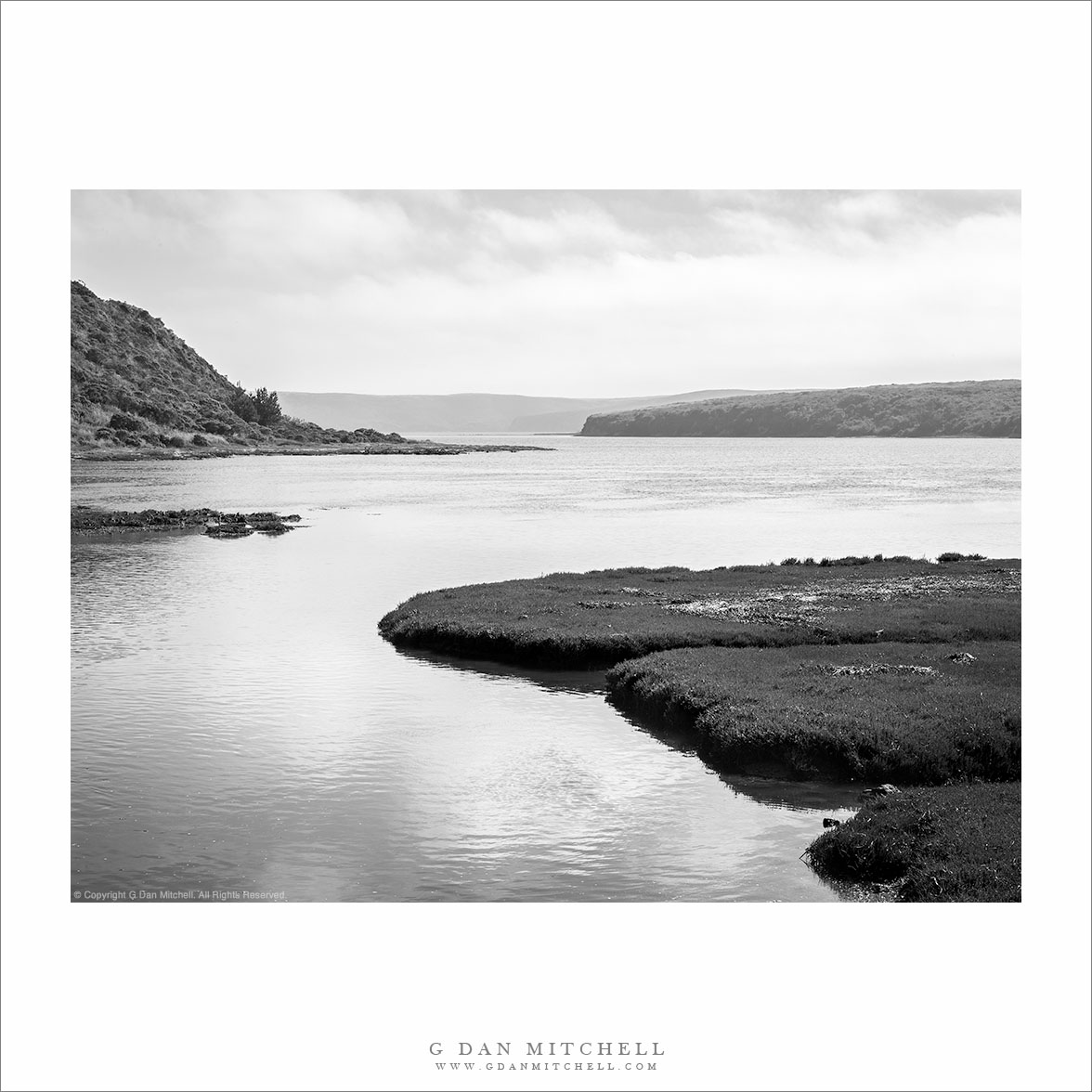
At a point where the trail descended to cross a dike at the head of Home Bay, I saw this conjunction of near and far forms, with the distant bluffs under the incoming fog, so I stopped to make a few photographs before moving on. To make a potentially long story a bit shorter, the temperature quickly dropped and the wind picked up to levels that made photography increasingly difficult. I managed to work with one other scene that included a curving snag in front of the bay, but it was already becoming difficult to find a calm moment in the wind to click the shutter. I kept going, finally reaching the trail junction that heads off towards Drakes Head, only to realize that I would never get all the way out there in time to return before dark. Cutting the hike short after a bit more than an hour and a half of hiking, I began to retrace my steps back to the trailhead.

In the end, this is really the only photograph that I came away with – despite carrying that fully loaded camera pack out and back! But this reminded me of a first lesson, namely that it is worth the effort even if I only come back with a single shot that I like. This one, to me, evokes the relative isolation and quiet of this spot in the upper reaches of the calm waters of Drakes Bay, with the fog bank beginning to assemble across the distant bluffs. A second lesson is that sometimes on a photographic quest, it is OK to simply enjoy the surroundings. A practical photographer can remind himself or herself that scouting is a good thing, and that things not photographed this time may well be on a future visit. And a long-time hiker can – and did – remind himself that sometimes it is just fine to leave the camera in the pack and just enjoy the wind and the space.


Leave a comment or question using the form. (Click the title to see the full article and to comment if you are viewing it on the home page.)

G Dan Mitchell is a California photographer and visual opportunist. His book, “California’s Fall Color: A Photographer’s Guide to Autumn in the Sierra” (Heyday Books) is available directly from him. Blog | Bluesky | Mastodon | Substack Notes | Flickr | Email

All media © Copyright G Dan Mitchell and others.

Zion Canyon, Virgin River, Spring

Zion Canyon, Virgin River, Spring - The Virgin River flows through Zion Canyon near Weeping Rock, Zion Canyon National Park, Utah.
The Virgin River flows through Zion Canyon near Weeping Rock, Zion Canyon National Park, Utah.

Zion Canyon, Virgin River, Spring. Zion National Park, Utah. April 4, 2012. © Copyright 2012 G Dan Mitchell – all rights reserved.

The Virgin River flows through Zion Canyon near Weeping Rock, Zion Canyon National Park, Utah.

On this morning we were back in Zion Canyon, following the Virgin River up the Valley to various locations. While it was still quite early we had walked up to the base of Weeping Rock, deep in the shaded area in the center of this photograph, and photographed there in the quiet shade. Then we moved a short distance up this part of the canyon where it makes a rather sharp series of turns and stopped an a place where there were visits up, down, and across the Virgin River and along the huge sandstone cliffs in all directions.

Looking around, I saw that there were some scattered clouds that were moving across the sky and alternative shading and lighting various portions of the landscape, and creating some dramatic effects, especially when the light came from behind the group of cottonwood trees along the banks of the river below me. The skeletal forms of the trees’ trunks were still clearly visible and, when the light was bright enough, they cast mirror-image shadows on the new grass below. The tops of the trees were fringed by new leaves, and these glowed brightly in the backlight coming from above the far cliffs above Weeping Rock. There was just enough haze in the air, amplified a bit by backlighting, to suggest the distance and massive size of the dark cliffs.

G Dan Mitchell is a California photographer whose subjects include the Pacific coast, redwood forests, central California oak/grasslands, the Sierra Nevada, California deserts, urban landscapes, night photography, and more.
Blog | About | Flickr | Twitter | FacebookGoogle+ | 500px.com | LinkedIn | Email

Text, photographs, and other media are © Copyright G Dan Mitchell (or others when indicated) and are not in the public domain and may not be used on websites, blogs, or in other media without advance permission from G Dan Mitchell.

White Rim Canyons

White Rim Canyons - Rugged canyon and plateau landscape of the White Rim area, photographed from Grand View, Canyonlands National Park.
Rugged canyon and plateau landscape of the White Rim area, photographed from Grand View, Canyonlands National Park.

White Rim Canyons. Canyonlands National Park, Utah. April 6, 2012. © Copyright 2012 G Dan Mitchell – all rights reserved.

Rugged canyon and plateau landscape of the White Rim area, photographed from Grand View, Canyonlands National Park.

I made this photograph on a day when we visited the “sky island” section of Canyonlands National Park, a high plateau fronted on many sides by steep cliffs and giant drop-offs. Since this was my first time in Canyonlands, I had a lot of reconnaissance to do before my planned evening shoot. We drove around sections of this part of the park, pausing at many overlooks to enjoy the view and consider the potential evening views. At one point we stopped at an overlook near the southern end of this section of the park to look and photograph.

The area in the photograph is the “white rim” area, where whitish colored rocks form a sort of tough terrace into which creeks have begun to carve canyons. The scale of the formations is tremendous, and the fact that two mighty rivers, the Colorado and the Green meet not too far from this point. This photograph was made well before the “ideal” golden hour time, but the low and slanting side-light and the rugged terrain of canyons and buttes seemed to compensate for that.

G Dan Mitchell is a California photographer whose subjects include the Pacific coast, redwood forests, central California oak/grasslands, the Sierra Nevada, California deserts, urban landscapes, night photography, and more.
Blog | About | Flickr | Twitter | FacebookGoogle+ | 500px.com | LinkedIn | Email

Text, photographs, and other media are © Copyright G Dan Mitchell (or others when indicated) and are not in the public domain and may not be used on websites, blogs, or in other media without advance permission from G Dan Mitchell.

Coal Chute Point and The Pit

Coal Chute Point and The Pit - Coal Chute Point, the Pit, and the rugged shoreline of Point Lobos State Reserve, California.

Coal Chute Point and The Pit. Point Lobos State Reserve, California. March 29, 2012. © Copyright 2012 G Dan Mitchell – all rights reserved.

Coal Chute Point, the Pit, and the rugged shoreline of Point Lobos State Reserve, California.

(Shortly after posting this, another photographer wrote to suggest that I might consider renaming the image to “Point and Chute.” ;-)

For all the years – decades, actually, and more than a few – that I’ve been visiting Point Lobos, there are still places that I have not gotten around to visiting within the boundaries of the park. Among them are some headlands not far from Whalers Cove that I’ve looked at for a long time… and then always headed off to some other part of the reserve without visiting them. Earlier this week I visited Point Lobos with no particular goal in mind aside from making some photographs, and I somehow finally ended up in this picturesque area that offers some quite different views from those found in the areas that more directly face out into the Pacific. (While it is, indeed, picturesque… the place names are not. Coal Chute Point? The Pit?)

The light in this photograph is somewhat subdued, at least in comparison to some of the photographs you might see of such a place, typically shot in the evening when the sky is at its most colorful. (Yes, I’ve certainly made my share of those photographs at Point Lobos, too!) But this light had a different sort of appeal, and it continuously changed during my half day there. When I arrived some fog was just clearing near the coast. It was a strange pattern – fog way inlands that looked more like the typical winter valley tule fog than the summer coastal fog. In fact, as is frequently the case in winter, it was clear at the coast. But somewhat surprisingly there was a regular old fog bank lurking a ways off the shoreline – and later in the day it moved in on the coast. Along with this there were high, thin clouds from a weather front that was passing well to the north. These conditions can still provide directional light but light which is softer and can fill in the shadows a bit – making it possible to shoot in places and at times of the day when the light might otherwise be too harsh. For this photograph I decided to “go wide,” and shoot with a 24mm focal length of a full frame DSLR to accentuate the distance between the foreground beach and the distant horizon and to include the full width of the curving wave as it broke on the beach.

G Dan Mitchell is a California photographer whose subjects include the Pacific coast, redwood forests, central California oak/grasslands, the Sierra Nevada, California deserts, urban landscapes, night photography, and more.
Blog | About | Flickr | Twitter | FacebookGoogle+ | 500px.com | LinkedIn | Email

Text, photographs, and other media are © Copyright G Dan Mitchell (or others when indicated) and are not in the public domain and may not be used on websites, blogs, or in other media without advance permission from G Dan Mitchell.